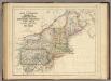
Maps of New York

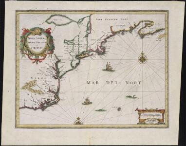
Nova Anglia, Novum Belgium et Virginia
A new chart of the coast of America from Philadelphia to Halifax Harbor / by Wm. Heather, 1809; Stephenson, engraver.
from Whole William Heather,

Tierra nveva.
from Charts and maps
[Côte de York-town à Boston : Marches de l'armée].
from Histoire des troubles de l'Amérique anglaise, ecrite sur les mémoires les plus authentiques ... par François Soulés ...
Belgii novi, angliae novae, et partis Virginiae : novissima delineatio
1 : 2450000 Jansson, Jan, 1588-1664 Prostant ... apud Petrum Schenk, et Gerardum Valk
Novi Belgii Novaeque Angliae nec non partis Virginiae tabula / multis in locis emendata per Nicolaum Visscher.
from John H. Levine Collection
Map of railways in the New England states : engraved expressly for Snow's pathfinder railway guide
Geo. K. Snow & Hapgood (Firm) Geo. K. Snow & Hapgood
A new map of the most considerable plantations of the English in America / Sutton Nicholls, sculp.
from Charts and maps Sutton Nicholls,
A new map of the most considerable plantations of the English in America / Sutton Nicholls, sculp.
from Charts and maps Sutton Nicholls,
Recens edita totius Novi Belgii in America Septentrionali siti
1 : 2250000 Seutter, Matthaeus, 1678-1756 Matthaei Seutteri
Totius Neobelgii nova et accuratissima tabula / [Hugo Allardt]
1 : 2500000 Annotatie: Lit.: The map collectors' circle, no. 24 (1965); Oorspr. uitg.: [Amsterdam] : Hugo Allardt, [ca. 1656] Allardt, Hugo [Amsterdam : Hugo Allardt excut.]
A new chart of America with the harbors of New York, Boston, &c / drawn from the latest authorities by W. Heather, 1799 ; Stephenson sculp.
from Charts and maps
Belgii novi, angliae novae, et partis Virginiae : novissima delineatio
1 : 2450000 Jansson, Jan, 1588-1664 Ioannes Ianssonius
A new map of the most considerable plantations of the English in America / Sutton Nicholls, sculp.
from Parts Sutton Nicholls,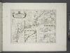
A new map of the most considerable plantations of the English in America / Sutton Nicholls, sculp.; A new sett of maps both of antient and present geography: wherein not only the latitude and longitude of many places are corrected according to the latest observations, but also the most remarkable differences of antient and present geography may be quickly discern'd by a bare inspection or comparing of correspondent maps, which seems to be the most natural and easy method to lead young students (for whose use the work is principally intended) unto a competent knowledge of the geographical science: together with a geographical treatise particularly adapted to the use and design of these maps / by Edward Wells, M.A. and student of Christ-Church, Oxon.
from A new sett of maps both of antient and present geography : wherein not only the latitude and longitude of many places are corrected according to the latest observations, but also the most remarkable differences of antient and present geography may be quickly discern'd by a bare inspection or comparing of correspondent maps, which seems to be the most natural and easy method to lead young students (for whose use the work is principally intended) unto a competent knowledge of the geographical science : together with a geographical treatise particularly adapted to the use and design of these maps / by Edward Wells, M.A. and student of Christ-Church, Oxon. Wells, Edward; Sheldonian Theatre,

G. Woolworth Colton's railroad, township & distance map of New England : with adjacent portions of New York, Canada & New Brunswick
1 : 900000 Colton, G. Woolworth (George Woolworth), 1827-1901 G. Woolworth Colton
Novi Belgii Novaeque Angliae nec non partis Virginiae tabula : multis in locis emendata
1 : 2250000 Visscher, Nicolaes, 1649-1702 Ex officina N. Visscher
Novi Belgii Novaeque Angliae nec non partis Virginiae tabula / multis in locis emendata a Nicolao Joannis Visschero
1 : 2500000 Annotatie: Lit.: The map collectors' circle, no. 24 (1965); Oorspr. uitg.: [Amsterdam : N.J. Visscher, ca. 1655] Visscher, Claes Jansz. [Amsterdam : nunc apud Petr. Schenk Iun.]
Pas caerte van Nieu Nederlandt en de Engelsche Virginies van Cabo Cod tot Cabo Canrick.
from De zee-atlas, ofte, Water-weereld : waer in vertoont werden alle de zee-kusten van het bekende des aerd-bodems : seer dienstigh voor alle heeren en kooplieden, als oock voor alle schippers en stuurlieden / gesneden, gedruckt en uytgegeven t'Amsteldam.
197-198. United States of America, North East. The World Atlas.
1 : 2500000 USSR (Union of Soviet Socialist Republics).
Novi Belgii Novaeque Angliae nec non partis Virginiae tabula multis in locis emendata
1 : 2000000 a Nicolao Joannis Visschero [S.l.] : [s.n.]
Carte réduite du Nord des Etat-Unis avec l'intérieur du pays, pour servirà l'intelligence de cette histoire.
from Histoire de la derniere guerre, entre la Grande-Bretagne, et les États-Unis de l'Amérique, la France, l'Espagne et la Hollande, depuis son commencement en 1775, jusqu'a sa fin en 1783 ...

A new map of New England, New York, New Iarsey, Pensilvania, Maryland, and Virginia / by Philip Lea in Cheap-side, London.
from Parts
Northern provinces of the United States

Map no. I : [to accompany A bill in the chancery of New Jersey, at the suit of John, Earl of Stair ... against Benjamin Bond].
from A bill in the chancery of New-Jersey, at the suit of John earl of Stair, and others, proprietors of the eastern-division of New-Jersey; against Benjamin Bond. and some other persons of Elizabeth-Town, distinguished by the name of the Clinker lot right men. With three large maps, done from copper-plates. To which is added; the publications of the Council of proprietors of East New-Jersey, and Mr. Nevill's speeches to the General assembly, concerning the riots committed in New-Jersey, and the pretences of the rioters, and their seducers. These papers will give a better light into the history and constitution of New-Jersey, than any thing hitherto published, the matters whereof have been chiefly collected from records. Published by subscription:
Carte réduite des côtes orientales de l'Amérique septentrionale: contenant celles des provinces de New-York et de la Nouvelle Angleterre, celles de l'Acadie ou Nouvelle Ecosse de l'Île Royale de l'Île St. Jean avec l'intérieur du pays / dressée au Dépôt général des cartes, plans et journaux de la marine, pour le service des vaisseaux du roi, par ordre de M. de Sartine, conseiller d'état, ministre et secrétaire d'état ayant le département de la marine; Petit, sculp.
from Parts M. de Sartine,