Maps of Queens County

Manhattan, V. 7, Plate No. 66 [Map bounded by W. 110th St., 5th Ave., Central Park West]
From Atlas 120. Vol. 7, 1902.
M-T-10-103: [Bounded by West 104th Street, West 105th Street, West 106th Street,West 107th Street, West Drive and The Loch.]
from Topographical survey of portion of Central Park, Boro. of Manhattan ... / City of New York, Department of Parks, Topographical Division.
Plate 101: Bounded by W. 105th Street, Central Park West, W. 100th Street and Amsterdam Avenue.
from Atlas of the borough of Manhattan, city of New York.
Plate 128: Bounded by W. 116th Street, Lenox Avenue, Cathedral Parkway and Eighth Avenue.
from Atlas of the borough of Manhattan, city of New York.
Part of Section 6: Plate 122.
from Atlas of the borough of Manhattan, city of New York.
M-T-10-105: [Bounded by West 100th Street, West 101st Street, West 102nd Street, West 103rd Street, West Drive and North Meadow.]
from Topographical survey of portion of Central Park, Boro. of Manhattan ... / City of New York, Department of Parks, Topographical Division.
M-T-10-106: [Bounded by North Meadow, East Drive, East 103rd Street, East 102nd Street, East 101st Street and East 100th Street.]
from Topographical survey of portion of Central Park, Boro. of Manhattan ... / City of New York, Department of Parks, Topographical Division.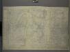
M-T-10-104: [Bounded by East Drive, Harlem Meer, East 106th Street, East 105th Street and East 104th Street.]
from Topographical survey of portion of Central Park, Boro. of Manhattan ... / City of New York, Department of Parks, Topographical Division.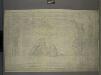
M-T-10-102: [Bounded by East Drive, West 110th Street, East 109th Street and East 108th Street.]
from Topographical survey of portion of Central Park, Boro. of Manhattan ... / City of New York, Department of Parks, Topographical Division.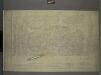
M-T-10-101: [Bounded by West 108th Street, West 109th Street, and Central Park Way.]
from Topographical survey of portion of Central Park, Boro. of Manhattan ... / City of New York, Department of Parks, Topographical Division.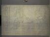
M-T-10-107: [Bounded by West 96th Street, West 97th Street, West 98th Street, West 99th Street, West Drive and North Meadow]
from Topographical survey of portion of Central Park, Boro. of Manhattan ... / City of New York, Department of Parks, Topographical Division.
M-T-10-108: [Bounded by North Meadow, East Drive, East 99th Street, East 98th Street, East 97t Street and East 96th Street.]
from Topographical survey of portion of Central Park, Boro. of Manhattan ... / City of New York, Department of Parks, Topographical Division.
Manhattan V. 7, Plate No. 47 [Map bounded by Columbus Ave., W. 105th St., Central Park West, W. 102nd St.]
From Atlas 121. Vol. 7, pt. 1, 1912.
Manhattan, V. 7, Plate No. 28 [Map bounded by W. 105th St., Central Park West, W. 100th St., Columbus Ave.]
From Atlas 120. Vol. 7, 1902.
Manhattan, V. 7, Plate No. 32 [Map bounded by Cathedral Parkway, Central Park West, W. 105th St., Columbus Ave.]
From Atlas 120. Vol. 7, 1902.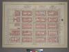
Plate 38, Part of Section 6: [Bounded by E. 105th Street, Third Avenue, E. 100th Street and (Central Park) Fifth Avenue.]
from Atlas of the city of New York, borough of Manhattan. From actual surveys and official plans / by George W. and Walter S. Bromley.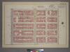
Plate 16, Part of Section 7: [Bounded by W. 105th Street, Central Park West, W. 100th Street and Amsterdam Avenue.]
from Atlas of the city of New York, borough of Manhattan. From actual surveys and official plans / by George W. and Walter S. Bromley.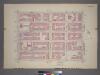
Plate 16, Part of Section 7: [Bounded by W. 105th Street, Amsterdam Avenue, W. 100th Street and (Hudson River - Riverside Park) Riverside Drive.]
from Atlas of the city of New York, borough of Manhattan. From actual surveys and official plans / by George W. and Walter S. Bromley.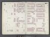
Manhattan, V. 8, Double Page Plate No. 167 [Map bounded by E. 105th St., 3rd Ave., E. 99th St., 5th Ave.]
From Atlas 122. Vol. 8, 1896.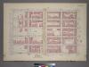
Plate 38, Part of Section 6: [Bounded by E. 105th Street, Third Avenue, E. 100th Street and First Avenue.]
from Atlas of the city of New York, borough of Manhattan. From actual surveys and official plans / by George W. and Walter S. Bromley.
Manhattan, V. 7, Plate No. 40 [Map bounded by W. 115th St., 5th Ave., W. 110th St., Lenox Ave.]
From Atlas 120. Vol. 7, 1902.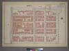
Plate 17, Part of Section 7: [Bounded by Cathedral Parkway, Central Park West, W. 105th Street, and Amsterdam Avenue.]
from Atlas of the city of New York, borough of Manhattan. From actual surveys and official plans / by George W. and Walter S. Bromley.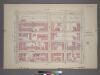
Plate 17, Part of Section 7: [Bounded by Cathedral Parkway, Central Park West, W. 105th Street and Amsterdam Avenue.]
from Atlas of the city of New York, borough of Manhattan. From actual surveys and official plans / by George W. and Walter S. Bromley.
Manhattan V. 7, Plate No. 40 [Map bounded by Columbus Ave., W. 102nd St., Central Park West, W. 99th St.]
From Atlas 121. Vol. 7, pt. 1, 1912.
Manhattan, V. 7, Plate No. 39 [Map bounded by W. 115th St., Lenox Ave., W. 110th St., 7th Ave.]
From Atlas 120. Vol. 7, 1902.
M-T-10-109: [Bounded by West 93rd Street, West 94th Street, West 95th Street, West 99th Street, West Drive and Bridle Path.]
from Topographical survey of portion of Central Park, Boro. of Manhattan ... / City of New York, Department of Parks, Topographical Division.
Manhattan, V. 7, Plate No. 24 [Map bounded by W. 100th St., Central Park West, W. 96th St., Columbus Ave.]
From Atlas 120. Vol. 7, 1902.
Manhattan, V. 7, Plate No. 38 [Map bounded by W. 115th St., 7th Ave., Cathedral Parkway, 8th Ave.]
From Atlas 120. Vol. 7, 1902.
Page 16: [Bounded by W. 114th Street, Fourth (Park) Avenue, (Spanish Harlem) E. 94th Street (Carnegie Hill) and Eighth Avenue.]
from Sackersdorf Farm Set.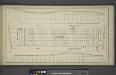
![Manhattan, V. 7, Plate No. 66 [Map bounded by W. 110th St., 5th Ave., Central Park West]](https://images-2.georeferencer.com/images/iiif/993595126815/full/,300/0/native.jpg)

