Maps of Queens County

Part of Section 6: Plate 122.
from Atlas of the borough of Manhattan, city of New York.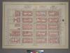
Plate 38, Part of Section 6: [Bounded by E. 105th Street, Third Avenue, E. 100th Street and (Central Park) Fifth Avenue.]
from Atlas of the city of New York, borough of Manhattan. From actual surveys and official plans / by George W. and Walter S. Bromley.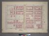
Plate 38, Part of Section 6: [Bounded by E. 105th Street, Third Avenue, E. 100th Street and First Avenue.]
from Atlas of the city of New York, borough of Manhattan. From actual surveys and official plans / by George W. and Walter S. Bromley.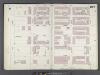
Manhattan, V. 8, Double Page Plate No. 167 [Map bounded by E. 105th St., 3rd Ave., E. 99th St., 5th Ave.]
From Atlas 122. Vol. 8, 1896.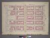
Plate 39, Part of Section 6: [Bounded by E. 110th Street, Third Avenue, E. 105th Street and Fifth Avenue.]
from Atlas of the city of New York, borough of Manhattan. From actual surveys and official plans / by George W. and Walter S. Bromley.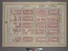
Plate 35, Part of Sections 5&6: [Bounded by E. 100th Street, Third Avenue, E. 95th Street and (Central Park) Fifth Avenue.]
from Atlas of the city of New York, borough of Manhattan. From actual surveys and official plans / by George W. and Walter S. Bromley.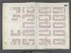
Manhattan, V. 8, Double Page Plate No. 168 [Map bounded by E. 110th St., 3rd Ave., E. 105th St., 5th Ave.]
From Atlas 122. Vol. 8, 1896.
M-T-10-106: [Bounded by North Meadow, East Drive, East 103rd Street, East 102nd Street, East 101st Street and East 100th Street.]
from Topographical survey of portion of Central Park, Boro. of Manhattan ... / City of New York, Department of Parks, Topographical Division.
23. Ward 12.
1 : 2400 G.W. Bromley & Co.; Geo. W. Bromley & E. Robinson
[Plate 32: Bounded by E. 108th Street, East River, E. 101st Street, Second Avenue, E. 97th Street and (Central Park) Fifth Avenue.]
from Atlas of the city of New York, Manhattan Island. From actual surveys and official plans / by George W. and Walter S. Bromley.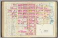
Pl. 32: ward 12.
1 : 1800 Bromley, George Washington; Bromley, Walter Scott
Part of Section 6 : New York City.
from Atlas of the city of New York, borough of Manhattan. From actual surveys and official plans / by George W. and Walter S. Bromley.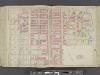
Manhattan, Double Page Plate No. 32 [Map bounded by E. 108thSt., East River, E. 97thSt., 5th Ave.]
From Atlas of the city of New York, Manhattan Island. From actual surveys and official plans
Manhattan, V. 7, Plate No. 66 [Map bounded by W. 110th St., 5th Ave., Central Park West]
From Atlas 120. Vol. 7, 1902.
[Plate 124: Bounded by E. 110th Street, Third Avenue, E. 105th Street and (Central Park) Fifth Avenue.]
from Atlas of the borough of Manhattan, city of New York.
Part of Sections 5 & 6: Plate 120.
from Atlas of the borough of Manhattan, city of New York.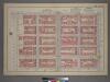
Plate 39, Part of Section 6: [Bounded by E. 110th Street, Third Avenue, E. 105th Street and Fifth Avenue.]
from Atlas of the city of New York, borough of Manhattan. From actual surveys and official plans / by George W. and Walter S. Bromley.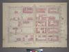
Plate 35, Part of Sections 5&6: [Bounded by E. 100th Street, Third Avenue, E. 95th Street and Fifth Avenue.]
from Atlas of the city of New York, borough of Manhattan. From actual surveys and official plans / by George W. and Walter S. Bromley.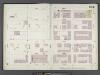
Manhattan, V. 8, Double Page Plate No. 164 [Map bounded by E. 99th St., 3rd Ave., E. 94th St., 5th Ave.]
From Atlas 122. Vol. 8, 1896.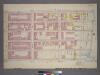
Plate 37, Part of Section 6: [Bounded by E. 105th Street, (Harlem River Piers) First Avenue, E. 100th Street and Third Avenue.]
from Atlas of the city of New York, borough of Manhattan. From actual surveys and official plans / by George W. and Walter S. Bromley.
Part of Section 6: Plate 125.
from Atlas of the borough of Manhattan, city of New York.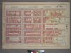
Plate 37, Part of Section 6: [Bounded by E. 105th Street, First Avenue, E. 100th Street and Third Avenue.]
from Atlas of the city of New York, borough of Manhattan. From actual surveys and official plans / by George W. and Walter S. Bromley.
Manhattan, V. 8, Double Page Plate No. 166 [Map bounded by E. 104th St., East River, Harlem River, E. 98th St. 3rd Ave.]
From Atlas 122. Vol. 8, 1896.
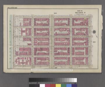
Part of Section 6: Plate 123
from Atlas of the borough of Manhattan, city of New York.
Manhattan, V. 8, Double Page Plate No. 169 [Map bounded by E. 110th St., Harlem River, E. 104th St., 3rd Ave.]
From Atlas 122. Vol. 8, 1896.
M-T-10-104: [Bounded by East Drive, Harlem Meer, East 106th Street, East 105th Street and East 104th Street.]
from Topographical survey of portion of Central Park, Boro. of Manhattan ... / City of New York, Department of Parks, Topographical Division.
M-T-10-108: [Bounded by North Meadow, East Drive, East 99th Street, East 98th Street, East 97t Street and East 96th Street.]
from Topographical survey of portion of Central Park, Boro. of Manhattan ... / City of New York, Department of Parks, Topographical Division.
M-T-10-102: [Bounded by East Drive, West 110th Street, East 109th Street and East 108th Street.]
from Topographical survey of portion of Central Park, Boro. of Manhattan ... / City of New York, Department of Parks, Topographical Division.
Sackersdorff Farm set.
from Maps of farms commonly called the Blue book, 1815 : drawn from the original on file in the street commissioner's office in the City of New York, together with lines of streets and avenues / laid out by John Randel, jr., 1819-20.