Maps of Queens County

Plate 128: Bounded by W. 116th Street, Lenox Avenue, Cathedral Parkway and Eighth Avenue.
from Atlas of the borough of Manhattan, city of New York.
Manhattan, V. 7, Plate No. 39 [Map bounded by W. 115th St., Lenox Ave., W. 110th St., 7th Ave.]
From Atlas 120. Vol. 7, 1902.
Manhattan, V. 7, Plate No. 38 [Map bounded by W. 115th St., 7th Ave., Cathedral Parkway, 8th Ave.]
From Atlas 120. Vol. 7, 1902.
M-T-10-101: [Bounded by West 108th Street, West 109th Street, and Central Park Way.]
from Topographical survey of portion of Central Park, Boro. of Manhattan ... / City of New York, Department of Parks, Topographical Division.
Manhattan, V. 7, Plate No. 47 [Map bounded by W. 120th St., Lenox Ave., W. 115th St., 7th Ave.]
From Atlas 120. Vol. 7, 1902.
Manhattan, V. 7, Plate No. 40 [Map bounded by W. 115th St., 5th Ave., W. 110th St., Lenox Ave.]
From Atlas 120. Vol. 7, 1902.
Manhattan, V. 7, Plate No. 37 [Map bounded by W. 115th Ave., 8th Ave., Cathedral Parkway, Manhattan Ave.]
From Atlas 120. Vol. 7, 1902.
Manhattan, V. 7, Plate No. 46 [Map bounded by W. 120th St., 7th Ave., W. 115th St., 8th Ave.]
From Atlas 120. Vol. 7, 1902.
Part of Section 7: New York City.
from Atlas of the city of New York, Manhattan Island. From actual surveys and official plans / by George W. and Walter S. Bromley.
Part of Section 7 : New York City.
from Atlas of the city of New York, borough of Manhattan. From actual surveys and official plans / by George W. and Walter S. Bromley.
Manhattan, Double Page Plate No. 35 [Map bounded by Manhattan Morningside Ave E., W. 125th St., Lenox Ave., W. 110th St.]
From Atlas of the city of New York, Manhattan Island. From actual surveys and official plans
Pl. 35: ward 12.
1 : 1800 Bromley, George Washington; Bromley, Walter Scott
Map of Morningside Park.
From Manhattan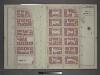
Plate 8: Part of Section 7.
from Atlas of the city of New York, borough of Manhattan / from actual surveys and official plans by George W. and Walter S. Bromley.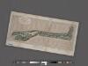
Preliminary Study for the Design of Morningside Park [1873].
From Manhattan
27. Ward 12.
1 : 2400 G.W. Bromley & Co.; Geo. W. Bromley & E. Robinson
Manhattan, V. 7, Plate No. 66 [Map bounded by W. 110th St., 5th Ave., Central Park West]
From Atlas 120. Vol. 7, 1902.
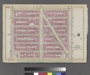
Plate 134: Bounded by W. 122nd Street, Lenox Avenue, W. 116th Street, and Eighth Avenue.
from Atlas of the borough of Manhattan, city of New York.
[Plate 9: Bounded by W. 122nd Street, Lenox Avenue, W. 116th Street and Eighth Avenue.]
from Atlas of the city of New York, borough of Manhattan / from actual surveys and official plans by George W. and Walter S. Bromley.
Part of Section 7: Plate 129
from Atlas of the borough of Manhattan, city of New York.
Plate 127: Bounded by W. 116th Street, Eighth Avenue, Cathedral Parkway and Amsterdam Avenue.
from Atlas of the borough of Manhattan, city of New York.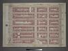
Plate 3: Section 6
from Atlas of the city of New York, borough of Manhattan / from actual surveys and official plans by George W. and Walter S. Bromley.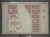
[Plate 5: Bounded by W. 116th Street, Eighth Avenue, Cathedral Parkway. and Amsterdam Avenue.]
from Atlas of the city of New York, borough of Manhattan / from actual surveys and official plans by George W. and Walter S. Bromley.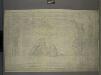
M-T-10-102: [Bounded by East Drive, West 110th Street, East 109th Street and East 108th Street.]
from Topographical survey of portion of Central Park, Boro. of Manhattan ... / City of New York, Department of Parks, Topographical Division.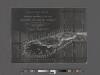
Revised general plan for Morningside Park, to accompany report by Frederick Law Olmsted and Calvert Vaux . . . September 28th, 1887.
From Manhattan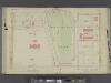
Manhattan, V. 6, Double Page Plate No. 14 [Map bounded by W. 114th St., 8th Ave., W. 110th Sst., 10th Ave.] / compiled from official records and actual surveys under the direction of E. Robinson and Roger H. Pidgeon.
From Vol. 6
Part of Section 7: Plate 103.
from Atlas of the borough of Manhattan, city of New York.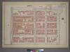
Plate 17, Part of Section 7: [Bounded by Cathedral Parkway, Central Park West, W. 105th Street, and Amsterdam Avenue.]
from Atlas of the city of New York, borough of Manhattan. From actual surveys and official plans / by George W. and Walter S. Bromley.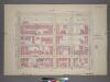
Plate 17, Part of Section 7: [Bounded by Cathedral Parkway, Central Park West, W. 105th Street and Amsterdam Avenue.]
from Atlas of the city of New York, borough of Manhattan. From actual surveys and official plans / by George W. and Walter S. Bromley.