Maps of Queens County

Manhattan, V. 7, Plate No. 39 [Map bounded by W. 115th St., Lenox Ave., W. 110th St., 7th Ave.]
From Atlas 120. Vol. 7, 1902.
Plate 128: Bounded by W. 116th Street, Lenox Avenue, Cathedral Parkway and Eighth Avenue.
from Atlas of the borough of Manhattan, city of New York.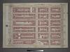
Plate 3: Section 6
from Atlas of the city of New York, borough of Manhattan / from actual surveys and official plans by George W. and Walter S. Bromley.
Manhattan, V. 7, Plate No. 38 [Map bounded by W. 115th St., 7th Ave., Cathedral Parkway, 8th Ave.]
From Atlas 120. Vol. 7, 1902.
M-T-10-101: [Bounded by West 108th Street, West 109th Street, and Central Park Way.]
from Topographical survey of portion of Central Park, Boro. of Manhattan ... / City of New York, Department of Parks, Topographical Division.
Manhattan, V. 7, Plate No. 40 [Map bounded by W. 115th St., 5th Ave., W. 110th St., Lenox Ave.]
From Atlas 120. Vol. 7, 1902.
M-T-10-102: [Bounded by East Drive, West 110th Street, East 109th Street and East 108th Street.]
from Topographical survey of portion of Central Park, Boro. of Manhattan ... / City of New York, Department of Parks, Topographical Division.
Manhattan, V. 7, Plate No. 47 [Map bounded by W. 120th St., Lenox Ave., W. 115th St., 7th Ave.]
From Atlas 120. Vol. 7, 1902.
Part of Section 7: New York City.
from Atlas of the city of New York, Manhattan Island. From actual surveys and official plans / by George W. and Walter S. Bromley.
Part of Section 7 : New York City.
from Atlas of the city of New York, borough of Manhattan. From actual surveys and official plans / by George W. and Walter S. Bromley.
Manhattan, Double Page Plate No. 35 [Map bounded by Manhattan Morningside Ave E., W. 125th St., Lenox Ave., W. 110th St.]
From Atlas of the city of New York, Manhattan Island. From actual surveys and official plans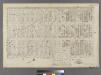
Plate 27: Bounded by Eighth Avenue, W. 129th Street, Fifth Avenue, W. 124th Street, Madison Avenue, W. 120th Street, Fifth Avenue and W. 110th Street.
from Atlas of the city of New York : embracing all territory within its corporate limits from official records, private plans & actual surveys / by and under the supervision of E. Robinson & R.H. Pidgeon, civil engineers.
Map of Morningside Park.
From Manhattan
Pl. 35: ward 12.
1 : 1800 Bromley, George Washington; Bromley, Walter Scott
Manhattan, Double Page Plate No. 34 [Map bounded by Lenox Ave., E. 125th St., 3rd Ave., E. 108th St.]
From Atlas of the city of New York, Manhattan Island. From actual surveys and official plans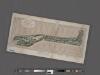
Preliminary Study for the Design of Morningside Park [1873].
From Manhattan
Part of Section 7: Plate 129
from Atlas of the borough of Manhattan, city of New York.
[Plate 34: Bounded by Lenox Avenue (6th Ave.), W. 125th Street, E. 125th Street, Third Avenue, E. 108th Street, and W. 110th Street.]
from Atlas of the city of New York, borough of Manhattan. From actual surveys and official plans / by George W. and Walter S. Bromley.
27. Ward 12.
1 : 2400 G.W. Bromley & Co.; Geo. W. Bromley & E. Robinson
Manhattan, V. 7, Plate No. 66 [Map bounded by W. 110th St., 5th Ave., Central Park West]
From Atlas 120. Vol. 7, 1902.
[Plate 34: Bounded by Lenox Avenue, W. 125th Street, Third Avenue, E. 108th Street, Fifth Avenue and (Central Park) W. 110th Street.]
from Atlas of the city of New York, Manhattan Island. From actual surveys and official plans / by George W. and Walter S. Bromley.
Plate 8: Part of Section 7.
from Atlas of the city of New York, borough of Manhattan / from actual surveys and official plans by George W. and Walter S. Bromley.
Pl. 38: ward 12.
1 : 1800 Bromley, George Washington; Bromley, Walter Scott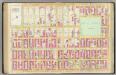
Pl. 34: ward 12.
1 : 1800 Bromley, George Washington; Bromley, Walter Scott
Plate 134: Bounded by W. 122nd Street, Lenox Avenue, W. 116th Street, and Eighth Avenue.
from Atlas of the borough of Manhattan, city of New York.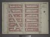
[Plate 9: Bounded by W. 122nd Street, Lenox Avenue, W. 116th Street and Eighth Avenue.]
from Atlas of the city of New York, borough of Manhattan / from actual surveys and official plans by George W. and Walter S. Bromley.
Plate 127: Bounded by W. 116th Street, Eighth Avenue, Cathedral Parkway and Amsterdam Avenue.
from Atlas of the borough of Manhattan, city of New York.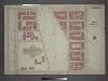
[Plate 5: Bounded by W. 116th Street, Eighth Avenue, Cathedral Parkway. and Amsterdam Avenue.]
from Atlas of the city of New York, borough of Manhattan / from actual surveys and official plans by George W. and Walter S. Bromley.
Plate 135: Bounded by W. 122nd Street, (Mount Morris Park) E. 122nd Street, Park Avenue, E. 116th Street, W. 116th Street and Lenox Avenue.
from Atlas of the borough of Manhattan, city of New York.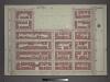
![Manhattan, V. 7, Plate No. 39 [Map bounded by W. 115th St., Lenox Ave., W. 110th St., 7th Ave.]](https://images-2.georeferencer.com/images/iiif/073188471836/full/,300/0/native.jpg)

