Maps of Hudson County
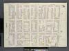
Brooklyn, V. 1, Double Page Plate No. 15 [Map bounded by Clinton St., Harrison St., Columbia St., State St.]
From Atlas 63. Vol. 1, 1886.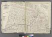
Plate 1: Part of Wards 1, 2, & 4. City of Brooklyn.
from Atlas of the entire city of Brooklyn, complete in one volume. From actual surveys and official records by G. W. Bromley & Co.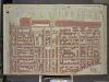
Brooklyn, Vol. 1, Double Page Plate No. 4; Part of Wards 1, Section 1; [Map bounded by Atlantic Ave., Furman St., Columbia Heights; Including Cranberry St., Fulton St., Clinton St.]
from Wards 1, 2, 3, 4, 5, 6, 8, 9, 10, 12 & 22.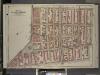
Brooklyn, Vol. 1, Double Page Plate No. 6; Part of Wards 1, 3, 6 & 10, Sections 1 & 2; [Map bounded by Hoyt St., Warren St.; Including Clinton St., Fulton St.]
from Wards 1, 2, 3, 4, 5, 6, 8, 9, 10, 12 & 22.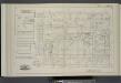
Vol. 5. Plate, E. [Map bound by Pierrepont St., Fulton St., Court St., Atlantic Ave., East River; Including Montague St., Remsen St., Grace Court, Joralemon St., Livingston St., Schermerhorn St., State St., Furman St., Pierrepont Ter., Montague Ter., Col
from Detailed estate and old farm line atlas of the city of Brooklyn : complete in six volumes ... from official records, private plans, and actual surveys ... / by G.M. Hopkins, C.E.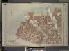
Brooklyn, Vol. 1, Double Page Plate No. 1; Part of Wards 1, 2 & 4, Section 1; [Map bounded by Plymouth St., Marshall St., John St., Jay St., High St.; Including Cranberry St., Furman St., Fulton St., Water St., Dock St.]
from Wards 1, 2, 3, 4, 5, 6, 8, 9, 10, 12 & 22.
[Plate 5: Map bounded by East River, Main Street, York Street, James, Street, Market]
from Maps of the city of Brooklyn
[Plate 6: Map bounded by Poplar Street, Henry Street]
from Maps of the city of Brooklyn
[Plate 16: Map bounded by Montague Street, Court Street, Atlantic Street, Henry Street]
from Maps of the city of Brooklyn
[Plate 17: Map bounded by Atlantic Street, Court Street, Degraw Street, Henry Street]
from Maps of the city of Brooklyn
Plate 14: Map bounded by Monroe Street, Pike Street, South Street, Catherine Street.
from Maps of the city of New York / surveyed under directions of insurance companies of said city.
[Plate 15: Map bounded by Pineapple Street, Fulton Avenue, Concord Street, Adams Street, Willoughby Street, Court Street, Montague Street, Henry Street]
from Maps of the city of Brooklyn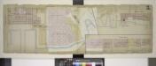
Double Page Plate No. 3; [Map bounded by Main St., Water St., Fulton St., Furman St.; Including East River, Ferry to Fulton St. New York, Empire Stores]
from Insurance maps of the warehouses, &c., in Brooklyn from the Navy yard to Partition Street.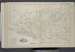
Vol. 5. Plate, B. [Map bound by East River, Bridge St., Sands St., Poplar St.; Including Marshall St., John St., PLymouth St., Water St., Front St., Fulton St., Doughty St., Vine St., York St., Franklin Pl., Talman St., Prospect St., Furman St., Columbia
from Detailed estate and old farm line atlas of the city of Brooklyn : complete in six volumes ... from official records, private plans, and actual surveys ... / by G.M. Hopkins, C.E.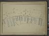
[Map bounded by Front St, Water St, Cherry St, Market Slip, Pier - Line 26-39; Including South Street, Peck Slip Ferry, Dover St, Roosevelt St, Ferry to Williamsburgh, James St, Oliver St, Catharine St, Catharine Ferry]
from Maps of the wharves & piers from the Battery to 61st street on the Hudson river and from the Battery to 41st street on the East river, New York. Surveyed by I.C. Buckhout, city surveyor.
Part of Section 1 : Plate 7.
from Atlas of the borough of Manhattan, city of New York.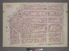
Plate 7, Part of Section 1: [Bounded by New Bowery Street, East Broadway, Pike Street, Pike Slip, South Street, and New Street.]
from Atlas of the city of New York, borough of Manhattan. From actual surveys and official plans / by George W. and Walter S. Bromley.
[Plate 11: Map bounded by Chatham Square, Division Street, Market Street, South Street, James Slip, James Street]
from Maps of the city of New York.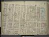
[Plate 11: Map bounded by Market Street, South Street, James Slip, James Street, Chatham Street, Chatham Square, Division Street; Including Catherine Street, Oliver Street, East Broadway, Bowery, Henry Street, Madison Street, Monroe Stre
from Maps of the city of New-York.
[Plate 30: Map bounded by Bergen Steet, Hoyt Street, Degraw Street, Court Street]
from Maps of the city of Brooklyn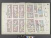
Manhattan, V. 1, Double Page Plate No. 12 [Map bounded by Rutgers St., East River, Market St., East Broadway]
From Atlas 107. Vol. 1, 1894.
[Plate 7: Map bounded by Pierrepont Street, Henry Street, Pacific Street, Buttermilk Channel]
from Maps of the city of Brooklyn
[Plate 12: Map bounded by Rutgers Street, South Street, Market Street, Division Street; Including Pelham St, Pike Street, Pike Slip, Birmingham Street Mechanic's Street, East Broadway, Henry Street, Madison Street, Monroe Street, Cherry Stree
from Maps of the city of New-York.
[Plate 12: Map bounded by Division Street, Rutgers Street, South Street, Market Street]
from Maps of the city of New York.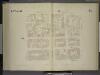
[4th Ward. Plate 11: Map bounded by Oak Street, Catharine Street, South Street, Roosevelt Street; Including Batavia Street, Cherry Street, Water Street, James Street, James Slip, Oliver Street]
from Maps of the city of New York.
[Plate 14: Map bounded by Market, James Street, York Street, Jay Street, Concord Street, Fulton Avenue, Pineapple Street, Henry Street, Fulton Avenue]
from Maps of the city of Brooklyn
[Plate 29: Map bounded by Joralemon Street, Fulton Street, Smith Street, Atlantic Avenue, Hoyt Street, Bergen Street, Court Street]
from Maps of the city of Brooklyn
Plate 12: Map bounded by Chatham Street, East Broadway, Chatham Square, Catherine Street, South Street, Roosevelt Street
from Maps of the city of New York / surveyed under directions of insurance companies of said city.
[Plate 13: Map bounded by Division Street, Pike Street, Monroe Street, Catherine Street.]
from Maps of the city of New York / surveyed under directions of insurance companies of said city.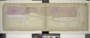
![Brooklyn, V. 1, Double Page Plate No. 15 [Map bounded by Clinton St., Harrison St., Columbia St., State St.]](https://images-2.georeferencer.com/images/iiif/243339734106/full/,300/0/native.jpg)

