Maps of Hudson County
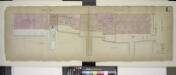
Double Page Plate No. 4; [Map bounded by Furman St., Montague St. (Raised); Including Ferry to Wall St. New York, East River]
from Insurance maps of the warehouses, &c., in Brooklyn from the Navy yard to Partition Street.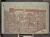
Brooklyn, Vol. 1, Double Page Plate No. 4; Part of Wards 1, Section 1; [Map bounded by Atlantic Ave., Furman St., Columbia Heights; Including Cranberry St., Fulton St., Clinton St.]
from Wards 1, 2, 3, 4, 5, 6, 8, 9, 10, 12 & 22.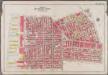
Plate 2: [Bounded by Clark Street, Fulton Street, Tillary Street, Gold Street, Willoughby Street, Bond Street, Atlantic Avenue, Court Street, Amity Street, Columbia Street, Atlantic Avenue and (East River) Furman Avenue]; Atlas of the borough of Brooklyn, city of New York: from actual surveys and official plans by George W. and Walter S. Bromley.
from Atlas of the borough of Brooklyn, city of New York : from actual surveys and official plans by George W. and Walter S. Bromley. G.W. Bromley & Co.,
Vol. 5. Plate, E. [Map bound by Pierrepont St., Fulton St., Court St., Atlantic Ave., East River; Including Montague St., Remsen St., Grace Court, Joralemon St., Livingston St., Schermerhorn St., State St., Furman St., Pierrepont Ter., Montague Ter., Col
from Detailed estate and old farm line atlas of the city of Brooklyn : complete in six volumes ... from official records, private plans, and actual surveys ... / by G.M. Hopkins, C.E.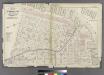
Plate 1: Part of Wards 1, 2, & 4. City of Brooklyn.
from Atlas of the entire city of Brooklyn, complete in one volume. From actual surveys and official records by G. W. Bromley & Co.
[Plate 6: Map bounded by Poplar Street, Henry Street]
from Maps of the city of Brooklyn
[Plate 7: Map bounded by Pierrepont Street, Henry Street, Pacific Street, Buttermilk Channel]
from Maps of the city of Brooklyn
Double Page Plate No. 5; [Map boounded by Montague St. (Raised), Furman St., Atlantic St.; Including East River, Joralemon St., Ferry To Wall St. New York]
from Insurance maps of the warehouses, &c., in Brooklyn from the Navy yard to Partition Street.
Wards 2 & 5 and Part of 1 &4. Land Map Section, No.1, Volume 1, Brooklyn Borough, New York City.
from Atlas of the Brooklyn borough of the City of New York : originally Kings Co.; complete in three volumes ... based upon official maps and plans ... / by and under the supervision of Hugo Ullitz, C.E.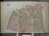
Brooklyn, Vol. 1, Double Page Plate No. 1; Part of Wards 1, 2, 4 & 5, Section 1; [Map bounded by East River, Gold St., Hudson Ave., Little St.; Including Navy St., Johnson St., Pierrepont St.]; Sub Plan No. 1; [Map bounded by Hudson Ave., East River, ...
From Volume 1
Part of Wards 1,3,4,6 &10. Land Map Sections, No.1&2, Volume 1, Brooklyn Borough, New York City.
from Atlas of the Brooklyn borough of the City of New York : originally Kings Co.; complete in three volumes ... based upon official maps and plans ... / by and under the supervision of Hugo Ullitz, C.E.
Plate 2: Bounded by Clark Street, Fulton Street, Tillary Street, Gold Street, Fulton Street, Bond Street, Atlantic Avenue, Court Street,Amity Street, Columbia Street, Atlantic Avenue and (East River Piers), Furman Street.
from Robinson's atlas of the city of Brooklyn, New York : embracing all territory within its corporate limits; from official records ... / by and under the supervision of E. Robinson and R.H. Pidgeon, civil engineers.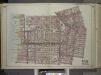
Brooklyn, Vol. 1, Double Page Plate No. 2; Part of Wards 1, 3, 4 & 6, Section 1 & 2; [Map bounded by Pierrepont St., Johnson St., Bridge St., Hoyt St., Smith St.; Including Warren St., Baltic St., East River, Furman St.] / by and under the direction o...
From Volume 1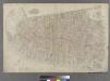
Part of Wards 1,2,4 & 6, New York City.
from Atlas of the city of New York : embracing all territory within its corporate limits from official records, private plans & actual surveys / by and under the supervision of E. Robinson & R.H. Pidgeon, civil engineers.
Sheet 2: [Bounded by Hudson Street, John Street, Gold Street, Bridge Street, Chapel Street, Jay Street, Myrtle Avenue, Pearl Street, Willoughby [Street], Boerum Street, Pacific Street, Columbia Street, Atlntic Street, Fulton Street, Water Street and Wash
from Plan of New York City, from the Battery to Spuyten Duyvil Creek. Showing every lot and building thereon; old farm lines, strreet numbers at the corners of blocks, railroads, steamboat landings, bulkhead and pier lines, etc. Based on the surveys made by Messrs. Randall & Blackwell, and on the special survey by J. F. Harrison.
Sheet 3: [Bounded by Reade Street, Nassau Street, Pearl Street, Chatham Street, Oliver Street, (Pier Line) South Street, (Battery) State Street, Battery Place and West Street.]
from Plan of New York City, from the Battery to Spuyten Duyvil Creek. Showing every lot and building thereon; old farm lines, strreet numbers at the corners of blocks, railroads, steamboat landings, bulkhead and pier lines, etc. Based on the surveys made by Messrs. Randall & Blackwell, and on the special survey by J. F. Harrison.
New York, the English colonial city, 1730 / [cartographic material]
From Early New York history, portrayed in five maps
Map of the city of New-York extending northward to Fiftieth St. / surveyed and drawn by John F. Harrison, C.E.
from Manhattan
Plan of the city of Brooklyn, L.I. / by William Perris.
from Brooklyn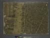
The city of New York / Will L. Taylor, chief draughtsman.
from Whole
Financial District map of New York City. Aero view of financial distrct above map.
From Manhattan
12C - N.Y. City (Aerial Set).
from Sectional aerial maps of the City of New York / [photographed and assembled under the direction of the chief engineer, July 1st, 1924].
Plan of the city of New York, 1808
1 : 7500 Longworth, David, 1765?-1821 Common Council
12D - N.Y. City (Aerial Set).
from Sectional aerial maps of the City of New York / [photographed and assembled under the direction of the chief engineer, July 1st, 1924].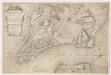
To His Excellency Sr. Henry Moore, Bart., captain general and governour in chief in & over the province of New York & the territories depending thereon in America, chancellor & vice admiral of the same, this plan of the city of New York is most humbly inscribed
1 : 4800 Ratzer, Bernard s.n.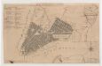
Plan of the city of New York
1 : 12500 Tiebout, Cornelius, 1777-1832 T. & J. Swords
[Map bounded by Pier - Line 39-46, King St, Washington Street, Vestry St; Including West Street, Canal St, Desbrosses St, Watts St, Hoboken St, Spring St, Charlton St]
from Maps of the wharves & piers from the Battery to 61st street on the Hudson river and from the Battery to 41st street on the East river, New York. Surveyed by I.C. Buckhout, city surveyor.
To His Excellency Sr. Henry Moore, Bart., captain general and governour in chief in & over the province of New York & the territories depending thereon in America, chancellor & vice admiral of the same, this plan of the city of New York is mo
from Charts and maps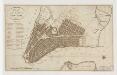
Plan of the city of New-York
1 : 12500 Tanner, Benjamin, 1775-1848 s.n.
![Double Page Plate No. 4; [Map bounded by Furman St., Montague St. (Raised); Including Ferry to Wall St. New York, East River]](https://images-2.georeferencer.com/images/iiif/513486031388/full/,300/0/native.jpg)

