Maps of Kings County

Plan of the city of Brooklyn, L.I. / by William Perris.
from Brooklyn
Financial District map of New York City. Aero view of financial distrct above map.
From Manhattan
New York, the English colonial city, 1730 / [cartographic material]
From Early New York history, portrayed in five maps
Map of the city of New-York extending northward to Fiftieth St. / surveyed and drawn by John F. Harrison, C.E.
from Manhattan
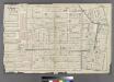
Sheet 3: [Bounded by Reade Street, Nassau Street, Pearl Street, Chatham Street, Oliver Street, (Pier Line) South Street, (Battery) State Street, Battery Place and West Street.]
from Plan of New York City, from the Battery to Spuyten Duyvil Creek. Showing every lot and building thereon; old farm lines, strreet numbers at the corners of blocks, railroads, steamboat landings, bulkhead and pier lines, etc. Based on the surveys made by Messrs. Randall & Blackwell, and on the special survey by J. F. Harrison.
A plan of the city of New York from an actual survey
1 : 3200 Lyne, James reproduced by Henry Dunreath Tyler
This plan of the city of New York (within the palisades which were erected in the year 1745) was made for the purpose of shewing the progress and extent of the Great Fire which happened in the year 1776, the number of houses that was consumed, and also the Fire of 1778
Grim, David Common Council
Part of Wards 1,2,4 & 6, New York City.
from Atlas of the city of New York : embracing all territory within its corporate limits from official records, private plans & actual surveys / by and under the supervision of E. Robinson & R.H. Pidgeon, civil engineers.
Sheet 2: [Bounded by Hudson Street, John Street, Gold Street, Bridge Street, Chapel Street, Jay Street, Myrtle Avenue, Pearl Street, Willoughby [Street], Boerum Street, Pacific Street, Columbia Street, Atlntic Street, Fulton Street, Water Street and Wash
from Plan of New York City, from the Battery to Spuyten Duyvil Creek. Showing every lot and building thereon; old farm lines, strreet numbers at the corners of blocks, railroads, steamboat landings, bulkhead and pier lines, etc. Based on the surveys made by Messrs. Randall & Blackwell, and on the special survey by J. F. Harrison.
2. Wards 1-2, 4.
1 : 2400 G.W. Bromley & Co.; Geo. W. Bromley & E. Robinson
A view of Collect Pond and its vicinity in the City of New York in 1793 : on which pond the first boat propelled by steam with paddle wheels or screw propellers was constructed by John Fitch, six years before Robert Fulton ... / by John Hutchings.
from Manhattan
[Plate 1: Bounded by Liberty Street, Maiden Lane, South Street [East River, Piers 1-18], White Hall Street, State Street (Battery Park), Battery Place,and (Hudson River, Piers A, 1-14) West Street.]
from Atlas of the city of New York, Manhattan Island. From actual surveys and official plans / by George W. and Walter S. Bromley.
Part of Section 1 : New York City.
from Atlas of the city of New York, borough of Manhattan. From actual surveys and official plans / by George W. and Walter S. Bromley.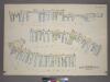
Plate 40: Plan of East River Wharves. [Covers the Wharves between Corlears Street - Maiden Lane on South Street.]
from Atlas of the city of New York, borough of Manhattan. From actual surveys and official plans / by George W. and Walter S. Bromley.
Ville de Manathe ou Nouvelle-Yorc.
from Manhattan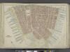
Manhattan, Double Page Plate No. 1 [Map bounded by Liberty St., Maiden Lane, East River, Hudson River]
From Atlas of the city of New York, Manhattan Island. From actual surveys and official plans
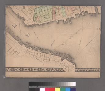
Plate 39: Bounded by Perry Street, West Street, Battery Place, State Street, Battery Park, and [Piers 1-47] Pierhead Line.
from Atlas of the borough of Manhattan, city of New York.
Part of Section 1 : New York City.
from Atlas of the city of New York, Manhattan Island. From actual surveys and official plans / by George W. and Walter S. Bromley.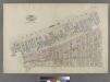
Part of Wards 1 & 3, New York City.
from Atlas of the city of New York : embracing all territory within its corporate limits from official records, private plans & actual surveys / by and under the supervision of E. Robinson & R.H. Pidgeon, civil engineers.
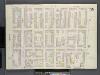
Plate 2: Bounded by Clark Street, Fulton Street, Tillary Street, Gold Street, Fulton Street, Bond Street, Atlantic Avenue, Court Street,Amity Street, Columbia Street, Atlantic Avenue and (East River Piers), Furman Street.
from Robinson's atlas of the city of Brooklyn, New York : embracing all territory within its corporate limits; from official records ... / by and under the supervision of E. Robinson and R.H. Pidgeon, civil engineers.
Part of Wards 1,3,4,6 &10. Land Map Sections, No.1&2, Volume 1, Brooklyn Borough, New York City.
from Atlas of the Brooklyn borough of the City of New York : originally Kings Co.; complete in three volumes ... based upon official maps and plans ... / by and under the supervision of Hugo Ullitz, C.E.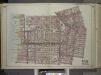
Brooklyn, Vol. 1, Double Page Plate No. 2; Part of Wards 1, 3, 4 & 6, Section 1 & 2; [Map bounded by Pierrepont St., Johnson St., Bridge St., Hoyt St., Smith St.; Including Warren St., Baltic St., East River, Furman St.] / by and under the direction o...
From Volume 1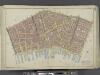
Manhattan, Double Page Plate No. 3 [Map bounded by William St., Park St., Market St., East River, Maiden Lane]
From Atlas of the city of New York, Manhattan Island. From actual surveys and official plans
Plate 39, Sec. 2 & Sec. 1: Plan of Hudson River Wharves. [Covers the Wharves between Perry Street - Battery Park on West Street.]
from Atlas of the city of New York, borough of Manhattan. From actual surveys and official plans / by George W. and Walter S. Bromley.
Nieuw Amsterdam: the Dutch settlement in the New World that became New York, following the plan sent October 6, 1660 by Governor Peter Stuyvesant to the West India Company in Holland, with additions concerning persons, places and events until the year 1699.
Brooklyn, V. 1, Double Page Plate No. 15 [Map bounded by Clinton St., Harrison St., Columbia St., State St.]
From Atlas 63. Vol. 1, 1886.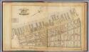
1. Ward 1,3.
1 : 2400 G.W. Bromley & Co.; Geo. W. Bromley & E. Robinson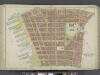
Manhattan, Double Page Plate No. 2 [Map bounded by Jay St., Thomas St., Pearl St., William St., Liberty St., Hudson River]
From Atlas of the city of New York, Manhattan Island. From actual surveys and official plans
Part of Section 1 : New York City.
from Atlas of the city of New York, Manhattan Island. From actual surveys and official plans / by George W. and Walter S. Bromley.