Maps of Hudson County

[Plate 11: Map bounded by Chatham Square, Division Street, Market Street, South Street, James Slip, James Street]
from Maps of the city of New York.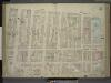
[Plate 11: Map bounded by Market Street, South Street, James Slip, James Street, Chatham Street, Chatham Square, Division Street; Including Catherine Street, Oliver Street, East Broadway, Bowery, Henry Street, Madison Street, Monroe Stre
from Maps of the city of New-York.
Plate 12: Map bounded by Chatham Street, East Broadway, Chatham Square, Catherine Street, South Street, Roosevelt Street
from Maps of the city of New York / surveyed under directions of insurance companies of said city.
[Plate 13: Map bounded by Division Street, Pike Street, Monroe Street, Catherine Street.]
from Maps of the city of New York / surveyed under directions of insurance companies of said city.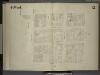
[4th Ward. Plate 12: Map bounded by Catharine Street, Oak Street, Roosevelt Street, Catham Street, Catham Square, Division St; Including Oliver Street, James Street, East Broadway, Henry Street, Madison Street]
from Maps of the city of New York.
Part of Section 1 : Plate 7.
from Atlas of the borough of Manhattan, city of New York.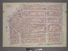
Plate 7, Part of Section 1: [Bounded by New Bowery Street, East Broadway, Pike Street, Pike Slip, South Street, and New Street.]
from Atlas of the city of New York, borough of Manhattan. From actual surveys and official plans / by George W. and Walter S. Bromley.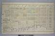
Map of the Rutger's Farm as it existed in 1784 / accurately made from reliable data by J.B. Holmes, C.E. & City Surveyor, April 1st, 1874.
from Manhattan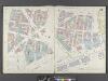
Manhattan, V. 1, Double Page Plate No. 10 [Map bounded by James St., South St., Dover St., Frankfort St., Rose St., Park Row]
From Atlas 107. Vol. 1, 1894.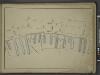
[Map bounded by Front St, Water St, Cherry St, Market Slip, Pier - Line 26-39; Including South Street, Peck Slip Ferry, Dover St, Roosevelt St, Ferry to Williamsburgh, James St, Oliver St, Catharine St, Catharine Ferry]
from Maps of the wharves & piers from the Battery to 61st street on the Hudson river and from the Battery to 41st street on the East river, New York. Surveyed by I.C. Buckhout, city surveyor.
[Plate 13: Map bounded by Canal Street, Division Street, Chatham Square, Mulberry Street, Cross Street, Mott Street]
from Maps of the city of New York.
[4th Ward. Plate 11: Map bounded by Oak Street, Catharine Street, South Street, Roosevelt Street; Including Batavia Street, Cherry Street, Water Street, James Street, James Slip, Oliver Street]
from Maps of the city of New York.
Plate 14: Map bounded by Monroe Street, Pike Street, South Street, Catherine Street.
from Maps of the city of New York / surveyed under directions of insurance companies of said city.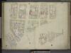
[Plate 13: Map bounded by Canal Street, Eldrige Street, Division Street, Chatham Street, Mulberry Street, Park Street, Mott Street; Including Bayard Street, Pell Street, Elizabeth Street, Mott Street, Catherine Street, Bowery, Chrystie
from Maps of the city of New-York.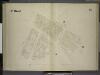
[4th Ward. Plate 9: Map bounded by Roosevelt Street, Oak Street, Pearl Street, Rose Street, Duane Street, Chatham Street; Including William Street, Madison Street]
from Maps of the city of New York.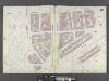
Manhattan, V. 1, Double Page Plate No. 13 [Map bounded by Canal St., East Broadway, Market St., Park Row, Milberry St., Park St., Mott St.]
From Atlas 107. Vol. 1, 1894.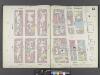
Manhattan, V. 1, Double Page Plate No. 12 [Map bounded by Rutgers St., East River, Market St., East Broadway]
From Atlas 107. Vol. 1, 1894.
[Plate 10: Map bounded by Chatham Street, James Street, South Street, Dover Street, Franklin Square, Frankfort Street, Fose Street, Duane Street]
from Maps of the city of New York.
[Plate 12: Map bounded by Rutgers Street, South Street, Market Street, Division Street; Including Pelham St, Pike Street, Pike Slip, Birmingham Street Mechanic's Street, East Broadway, Henry Street, Madison Street, Monroe Street, Cherry Stree
from Maps of the city of New-York.
[Plate 12: Map bounded by Division Street, Rutgers Street, South Street, Market Street]
from Maps of the city of New York.
Manhattan, V. 1, Plate No. 54 [Map bounded by Market St., E. Broadway, Rutgers St., Monroe St.]
From Atlas 108. Vol. 1, [1903?].
Part of Sections 1 & 2 : New York City.
from Atlas of the city of New York, borough of Manhattan. From actual surveys and official plans / by George W. and Walter S. Bromley.
Part of Sections 1 & 2 : New York City.
from Atlas of the city of New York, Manhattan Island. From actual surveys and official plans / by George W. and Walter S. Bromley.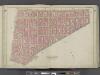
Manhattan, Double Page Plate No. 5 [Map bounded by Broome St., Division St., Pearl St., Centre St.]
From Atlas of the city of New York, Manhattan Island. From actual surveys and official plans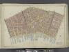
Manhattan, Double Page Plate No. 3 [Map bounded by William St., Park St., Market St., East River, Maiden Lane]
From Atlas of the city of New York, Manhattan Island. From actual surveys and official plans
Part of Section 1 : New York City.
from Atlas of the city of New York, Manhattan Island. From actual surveys and official plans / by George W. and Walter S. Bromley.
Part of Section 1 : New York City.
from Atlas of the city of New York, borough of Manhattan. From actual surveys and official plans / by George W. and Walter S. Bromley.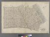
[Plate 5: Bounded by Clinton Street, Madison Street, Jefferson Street, Cherry Street, Rutgers Slip, South Street (East River, Piers 32-44), James Slip, New Chambers Street, New Bowery Street, Bowery Street and Rivington Street.]
from Atlas of the city of New York : embracing all territory within its corporate limits from official records, private plans & actual surveys / by and under the supervision of E. Robinson & R.H. Pidgeon, civil engineers.
Sanitary and social chart of the Fourth Ward of the City of New York, to accompany a report of the 4th Sanitary Inspection District.
From Manhattan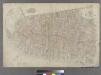
![[Plate 11: Map bounded by Chatham Square, Division Street, Market Street, South Street, James Slip, James Street]](https://images-2.georeferencer.com/images/iiif/956174811008/full/,300/0/native.jpg)

