Maps of Hudson County
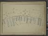
[Map bounded by Front St, Water St, Cherry St, Market Slip, Pier - Line 26-39; Including South Street, Peck Slip Ferry, Dover St, Roosevelt St, Ferry to Williamsburgh, James St, Oliver St, Catharine St, Catharine Ferry]
from Maps of the wharves & piers from the Battery to 61st street on the Hudson river and from the Battery to 41st street on the East river, New York. Surveyed by I.C. Buckhout, city surveyor.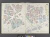
Manhattan, V. 1, Double Page Plate No. 10 [Map bounded by James St., South St., Dover St., Frankfort St., Rose St., Park Row]
From Atlas 107. Vol. 1, 1894.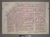
Plate 7, Part of Section 1: [Bounded by New Bowery Street, East Broadway, Pike Street, Pike Slip, South Street, and New Street.]
from Atlas of the city of New York, borough of Manhattan. From actual surveys and official plans / by George W. and Walter S. Bromley.
Part of Section 1 : Plate 7.
from Atlas of the borough of Manhattan, city of New York.
Plate 11: Map bounded by Cliff Street, Frankfort Street, Pearl Street, Oak Street, Roosevelt Street, South Street, Peck Slip, Ferry Street
from Maps of the city of New York / surveyed under directions of insurance companies of said city.
[4th Ward. Plate 11: Map bounded by Oak Street, Catharine Street, South Street, Roosevelt Street; Including Batavia Street, Cherry Street, Water Street, James Street, James Slip, Oliver Street]
from Maps of the city of New York.
Plate 14: Map bounded by Monroe Street, Pike Street, South Street, Catherine Street.
from Maps of the city of New York / surveyed under directions of insurance companies of said city.
Plate 12: Map bounded by Chatham Street, East Broadway, Chatham Square, Catherine Street, South Street, Roosevelt Street
from Maps of the city of New York / surveyed under directions of insurance companies of said city.
[Plate 10: Map bounded by Chatham Street, James Street, South Street, Dover Street, Franklin Square, Frankfort Street, Fose Street, Duane Street]
from Maps of the city of New York.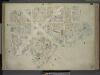
[Plate 10: Map bounded by James Street, South Street, Dover Street, Rose Street, Duane Street, Chatham Street; Including Roosevelt Street, Chesnut Street, Pearl Street, Franklin Square, Bowery, Chambers Street, Cliff Street, Jacob Street, Gold St
from Maps of the city of New-York.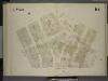
[4th Ward. Plate 10: Map bounded by Peck Slip, Pearl Street, Franklin Square, Pearl Street, Oak Street, Roosevelt Street, South Street; Including Dover Street, Front Street, Water Street, Cherry Street]
from Maps of the city of New York.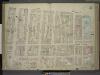
[Plate 11: Map bounded by Market Street, South Street, James Slip, James Street, Chatham Street, Chatham Square, Division Street; Including Catherine Street, Oliver Street, East Broadway, Bowery, Henry Street, Madison Street, Monroe Stre
from Maps of the city of New-York.
[Plate 11: Map bounded by Chatham Square, Division Street, Market Street, South Street, James Slip, James Street]
from Maps of the city of New York.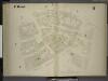
[4th Ward. Plate 8: Map bounded by Gold Street, Frankfort Street, Rose Street, Madison Street, Pearl Street, Oak Street, Franklin Square, Ferry Street; Jacob Street, Vandewater Street, Cliff Street]
from Maps of the city of New York.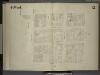
[4th Ward. Plate 12: Map bounded by Catharine Street, Oak Street, Roosevelt Street, Catham Street, Catham Square, Division St; Including Oliver Street, James Street, East Broadway, Henry Street, Madison Street]
from Maps of the city of New York.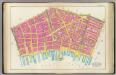
Pl. 3: wards 2, 4, 7.
1 : 1800 Bromley, George Washington; Bromley, Walter Scott
Sanitary and social chart of the Fourth Ward of the City of New York, to accompany a report of the 4th Sanitary Inspection District.
From Manhattan
[Plate 4: Bounded by William Street, Ann Street, Gold Street, Beekman Street, Cliff Street, Dover Street, Cherry Street, Greenwich Street, Roosevelt Street, South Street, Pine Street, Pearl Street, and Cedar Street.]
from Atlas of the borough of Manhattan, city of New York.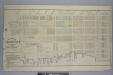
Map of the Rutger's Farm as it existed in 1784 / accurately made from reliable data by J.B. Holmes, C.E. & City Surveyor, April 1st, 1874.
from Manhattan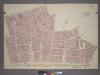
Plate 4, Part of Section 1: [Bounded by William Street, Ann Street, Gold Street, Beekman Street, Cliff Street, Dover Street, Cherry Street, Roosevelt Street, South Street, Pine Street, Pearl Street and Cedar Street.]
from Atlas of the city of New York, borough of Manhattan. From actual surveys and official plans / by George W. and Walter S. Bromley.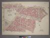
Plate 6, Part of Section 1: [Bounded by Reade Street, Duane Street, New Chambers Street, Roosevelt Street, Cherry Street, Franklin Square, Frankfort Street, Cliff Street, Beekman Street, Gold Street and Ann Street.]
from Atlas of the city of New York, borough of Manhattan. From actual surveys and official plans / by George W. and Walter S. Bromley.
Part of Section 1 : Plate 6.
from Atlas of the borough of Manhattan, city of New York.
[Plate 5: Map bounded by Gold Street, Frankfort Street, Dover Street, South Street, Maiden Lane; Including Riders Alley, Jacob Street, Cliff Street, Pearl Street, Water Street, Front Street, Fletcher Street, Platt Street, John Street, Burling
from Maps of the city of New-York.
Manhattan, V. 1, Plate No. 5 [Map bounded by Gold St., Dover St., Frankfort St., South St., Fulton St.]
From Atlas 107. Vol. 1, 1894.
[4th Ward. Plate 9: Map bounded by Roosevelt Street, Oak Street, Pearl Street, Rose Street, Duane Street, Chatham Street; Including William Street, Madison Street]
from Maps of the city of New York.
[Plate 5: Map bounded by Frankfort Street, Franklin Square, Dover Street, South Street, Maiden Lane, Gold Street]
from Maps of the city of New York.
[Plate 13: Map bounded by Division Street, Pike Street, Monroe Street, Catherine Street.]
from Maps of the city of New York / surveyed under directions of insurance companies of said city.
Manhattan, V. 1, Double Page Plate No. 12 [Map bounded by Rutgers St., East River, Market St., East Broadway]
From Atlas 107. Vol. 1, 1894.
[Plate 12: Map bounded by Rutgers Street, South Street, Market Street, Division Street; Including Pelham St, Pike Street, Pike Slip, Birmingham Street Mechanic's Street, East Broadway, Henry Street, Madison Street, Monroe Street, Cherry Stree
from Maps of the city of New-York.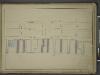
![[Map bounded by Front St, Water St, Cherry St, Market Slip, Pier - Line 26-39; Including South Street, Peck Slip Ferry, Dover St, Roosevelt St, Ferry to Williamsburgh, James St, Oliver St, Catharine St, Catharine Ferry]](https://images-2.georeferencer.com/images/iiif/193667314649/full/,300/0/native.jpg)

