Maps of Bronx County
Queens, Vol. 2A, Double Page Plate No. 31; Part of Ward Two Newtown. [Map bounded by Lurting St., Flushing River, Rodman St.; Including Corona Ave., Tiemann Ave.] / by and under the supervision of Hugo Ullitz.
From v. 2A
New York City.
1 : 43500 Rand McNally and Company
Shell Greater New York City, Manhattan, Bronx, Brooklyn, Queens.
1 : 50688 Shell Oil Company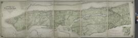
Topographical atlas of the city of New York, including the annexed territory showing original water courses and made land.
from Topographical atlas of the city of New York, / including the annexed territory showing original water courses and made land / prepared under the direction of Egbert L. Viele.
Map of the city and county of New York : with the adjacent country / by David H. Burr.
from An atlas of the state of New York : containing a map of the state and of the several counties / by David H. Burr.
1907 library map of Manhattan, City of New York.
From Manhattan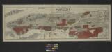
Map of the borough of Manhattan and part of the Bronx showing location and extent of racial colonies.
From Manhattan
The Flushing and North Side Railroad, with its leased branches.
from Atlas of Long Island, New York. From recent and actual surveys and records.
N.Y. City, Brooklyn.
1 : 41500 Bien, Joseph Rudolf
New York City.
1 : 41000 Rand McNally and Company
New York City, County.
1 : 31680 Vermeule, C. C. (Cornelius Clarkson), 1858-1950
1. New York City.
1 : 80000 Servoss, R. D.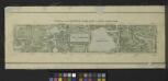
Plan of The Central Park, City of New York, 1860
from Manhattan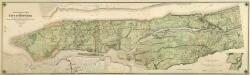
Composite: Topographical Atlas Of The City Of New York
1 : 12000 Viele, Egbert L.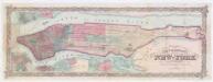
Colton's city & county map of New-York
1 : 20000 G.W. & C.B. Colton & Co G.W. and C.B. Colton
Heart of New York.
1 : 29800 New York Central Railroad Company
New handy map of the borough of the Bronx.
From Bronx
[Map of the city of New York and island of Manhattan as laid out by the commissioners appointed by the Legislature, April 3, 1807]
from Manhattan
1. New York City.
1 : 80000 Servoss, R. D.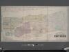
Colton's new map of the city and county of New York [North and South of 93rd St.] including the extension north of the Harlem River.
From Manhattan
TheHeart of New York: Grand Central Terminal: Only Railway Station on the Subway, Elevated, and Surface Lines.
From Manhattan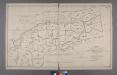
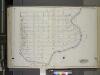
Index to the Location of the Sections and Pages of Final Maps and Profiles, showing the street system in the 23rd and 24th Wards, in the City of New york. [Grid #5000W - 20000E, #15000N - 30000S.]
from Maps or plans and profiles, with field notes and explanatory remarks, showing the location, width, grades, and class of streets, roads, avenues, public squares and places, located and laid out by the Commissioner of Street Improvements of the 23rd and 24th wards of the city of New York : under authority of Chapter 545 of the laws of 1890.
New handy map of New York City.
From Manhattan
New Map of the Borough of the Bronx.
From Bronx
Long I. Sound, Westchester, Queens.
1 : 31680 Vermeule, C. C. (Cornelius Clarkson), 1858-1950
New York City
from New topographical atlas and gazetteer of New York, comprising a topographical view of the several counties of the state, ... including ... map of the United States and territories ... Compiled from the latest astronomical observations, official surveys and records of the United States and territories ...
Map of part of New York City, showing underground mains of the Edison Electric Illuminating Co. of New York.
From Manhattan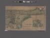
Topographical map of the city of New York, showing original water courses and made land ; prepared under direction of Egbert L. Viele, Topogr. Eng'r. Bound with his Topography and Hydrology of New York.
From Manhattan
Morrisania, Westchester Co. N.Y.
from County atlas of Westchester, New York. Published by J.B. Beers & Co., assisted by S.W. Wilson and others.
![Queens, Vol. 2A, Double Page Plate No. 31; Part of Ward Two Newtown. [Map bounded by Lurting St., Flushing River, Rodman St.; Including Corona Ave., Tiemann Ave.] / by and under the supervision of Hugo Ullitz.](https://images-0.georeferencer.com/images/iiif/931716564402/full/,300/0/native.jpg)

