Maps of Bronx County
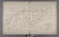
Index to the Location of the Sections and Pages of Final Maps and Profiles, showing the street system in the 23rd and 24th Wards, in the City of New york. [Grid #5000W - 20000E, #15000N - 30000S.]
from Maps or plans and profiles, with field notes and explanatory remarks, showing the location, width, grades, and class of streets, roads, avenues, public squares and places, located and laid out by the Commissioner of Street Improvements of the 23rd and 24th wards of the city of New York : under authority of Chapter 545 of the laws of 1890.
New Map of the Borough of the Bronx.
From Bronx
1907 library map of Manhattan, City of New York.
From Manhattan
New Map of the Borough of the Bronx, City of New York . . . Circular stickers mark Carnegie Library sites.
From Bronx
Harlem
1 : 62500
Harlem
1 : 62500
Harlem
1 : 62500
Harlem
1 : 62500
Harlem
1 : 62500
Harlem
1 : 62500
Harlem
1 : 62500
Harlem
1 : 62500
Harlem
1 : 62500
Harlem
1 : 62500
Harlem
1 : 62500
Harlem
1 : 62500
Harlem
1 : 62500
Harlem
1 : 62500
Harlem
1 : 62500
Harlem
1 : 62500
Harlem
1 : 62500
Harlem
1 : 62500
Harlem
1 : 62500
Harlem
1 : 62500
Harlem
1 : 62500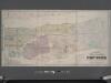
Colton's new map of the city and county of New York [North and South of 93rd St.] including the extension north of the Harlem River.
From Manhattan
2. Harlem-Yonkers-Pelham Manor.
1 : 80000 Servoss, R. D.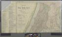
Map of New York City showing portions of Brooklyn, Jersey City, and Westchester Co.
from Whole
Index to the Topographical survey sheets of the borough of the Bronx easterly of the Bronx River.
from Topographical survey and new street system of the borough of the Bronx, easterly of the Bronx River
![Index to the Location of the Sections and Pages of Final Maps and Profiles, showing the street system in the 23rd and 24th Wards, in the City of New york. [Grid #5000W - 20000E, #15000N - 30000S.]](https://images-0.georeferencer.com/images/iiif/447143380506/full/,300/0/native.jpg)

