Maps of Bronx County

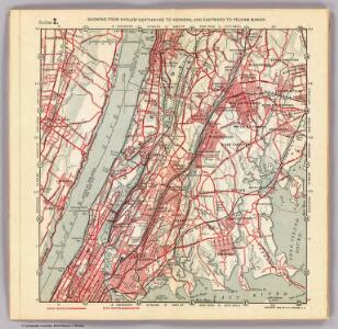
2. Harlem-Yonkers-Pelham Manor.
1 : 80000 Servoss, R. D.
Index to the Location of the Sections and Pages of Final Maps and Profiles, showing the street system in the 23rd and 24th Wards, in the City of New york. [Grid #5000W - 20000E, #15000N - 30000S.]
from Maps or plans and profiles, with field notes and explanatory remarks, showing the location, width, grades, and class of streets, roads, avenues, public squares and places, located and laid out by the Commissioner of Street Improvements of the 23rd and 24th wards of the city of New York : under authority of Chapter 545 of the laws of 1890.
Map of the Bronx. [including part of Yonkers, Mount Vernon, and New Rochelle].
From Bronx
1 Bronx.
1 : 18000 Hyde & Company
Map of the Borough of the Bronx, City of New York, showing street pavements on January 1st, 1913.
From Bronx
2. Harlem-Yonkers-Pelham Manor.
1 : 80000 Servoss, R. D.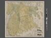
New Standard map of the Borough of Bronx.
From Bronx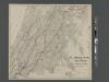
Map of the Bronx showing present and proposed transit system.
From Bronx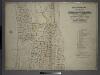
Index to Volume Two: Atlas of the Borough of the Bronx, City of New York. Part of 24th Ward.
from Atlas of the borough of the Bronx, city of New York : based upon official plans and maps on file in the various city offices; supplemented by careful field measurements and personal observations, by and under the supervision of Hugo Ullitz.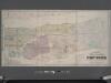
Colton's new map of the city and county of New York [North and South of 93rd St.] including the extension north of the Harlem River.
From Manhattan
Morrisania, Westchester Co. N.Y.
from County atlas of Westchester, New York. Published by J.B. Beers & Co., assisted by S.W. Wilson and others.
Plans of Westchester, West Farms, Morrisania, Westchester County and Part of New York County. New York.
1 : 42240 Beers, Frederick W.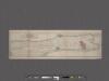
Guide Map to 92 Acres of Land at Washington Heights in the 12th Ward of the City of New York to be sold by the executors of Isaac Dykman Decd.
From Manhattan
Map or plan showing the system of streets, avenues, public squares and places, parks, bridges, etc. in that part of the borough of the Bronx, City of New York lying easterly of the Bronx River.
From Bronx
A topographical map of the northn. part of New York Island : exhibiting the plan of Fort Washington, now Fort Knyphausen, with the rebels lines to the southward, which were forced by the troops under the command of the Rt. Honble. Earl Percy on the 16th. Novr. 1776, and survey'd immediately after by order of His Lordship
1 : 20000 Sauthier, Claude Joseph Wm. Faden
Topographical atlas of the city of New York, including the annexed territory showing original water courses and made land. / prepared under the direction of Egbert L. Viele.
From Topographical atlas of the city of New York, including the annexed territory showing original water courses and made land
Plate 50: Town of Westchester, Westchester Co. N.Y.
from County atlas of Westchester, New York. Published by J.B. Beers & Co., assisted by S.W. Wilson and others.
[Map of the city of New York and island of Manhattan as laid out by the commissioners appointed by the Legislature, April 3, 1807]
From Manhattan
From New York to Stratford. (2)
1 : 35000 Colles, Christopher
Plates 21 & 22: Town and City of Yonkers, Westchester Co. N.Y. - Town of East Chester, Westchester Co. N.Y.
From County atlas of Westchester, New York. Published by J.B. Beers & Co., assisted by S.W. Wilson and others.
Washington Heights, Inwood, Marble Hill. (cont.)
From District 12
Hammods Atlas of New York City and the metropolitan district

Plates 21 & 22: Town and City of Yonkers, Westchester Co. N.Y. - Town of East Chester, Westchester Co. N.Y.
from County atlas of Westchester, New York. Published by J.B. Beers & Co., assisted by S.W. Wilson and others.
Westchester, Pelham towns.
1 : 21120 Bien, Joseph Rudolf
Topographical atlas of the city of New York, including the annexed territory showing original water courses and made land. / prepared under the direction of Egbert L. Viele.
From Topographical atlas of the city of New York, including the annexed territory showing original water courses and made land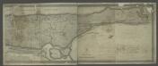
[Map of the city of New York and island of Manhattan as laid out by the commissioners appointed by the Legislature, April 3, 1807]
from Manhattan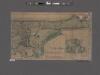
Topographical map of the city of New York, showing original water courses and made land ; prepared under direction of Egbert L. Viele, Topogr. Eng'r. Bound with his Topography and Hydrology of New York.
From Manhattan
Morrisania, Westchester Co. N.Y.
from County atlas of Westchester, New York. Published by J.B. Beers & Co., assisted by S.W. Wilson and others.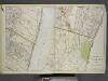
Portion of Bergen County, N.J.; Portion of Yonkers and 24th Ward.
from Atlas of the Hudson River Valley from New York city to Troy, including a section of about 8 miles in width. Published by Watson & co. Compiled from official records and careful surveys, under the supervision of F. W. Beers.