Maps of Bronx County

Maps of Bronx County

$title$

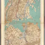
Long I. Sound, Westchester, Queens.

1 : 31680 Vermeule, C. C. (Cornelius Clarkson), 1858-1950
$title$

The Flushing and North Side Railroad, with its leased branches.

from Atlas of Long Island, New York. From recent and actual surveys and records.
$title$

Plate 24: Northern part of Town of Yonkers, adjacent to the River.

from Atlas of New York and vicinity : from actual surveys / by and under the direction of F. W. Beers, assisted by A. B. Prindle & others
$title$

New handy map of the borough of the Bronx.

From Bronx
$title$

New York City.

1 : 43500 Rand McNally and Company
$title$

New Map of the Borough of the Bronx.

From Bronx
$title$

Index to the Topographical survey sheets of the borough of the Bronx easterly of the Bronx River.

from Topographical survey and new street system of the borough of the Bronx, easterly of the Bronx River
$title$

New Standard map of the Borough of Bronx.

From Bronx
$title$

Queens, Vol. 2A, Double Page Plate No. 31; Part of Ward Two Newtown. [Map bounded by Lurting St., Flushing River, Rodman St.; Including Corona Ave., Tiemann Ave.] / by and under the supervision of Hugo Ullitz.

From v. 2A
$title$

Map of the Bronx. [including part of Yonkers, Mount Vernon, and New Rochelle].

From Bronx
$title$

Index to the Location of the Sections and Pages of Final Maps and Profiles, showing the street system in the 23rd and 24th Wards, in the City of New york. [Grid #5000W - 20000E, #15000N - 30000S.]

from Maps or plans and profiles, with field notes and explanatory remarks, showing the location, width, grades, and class of streets, roads, avenues, public squares and places, located and laid out by the Commissioner of Street Improvements of the 23rd and 24th wards of the city of New York : under authority of Chapter 545 of the laws of 1890.
$title$

Plate 29: Town of Flushing. - Douglaston. - Bay Side.

from Atlas of Queens Co., Long Island, New York / compiled from official records, private plans & actual surveys by and under the direction of Chester Wolverton.
$title$

Map or plan showing the system of streets, avenues, public squares and places, parks, bridges, etc. in that part of the borough of the Bronx, City of New York lying easterly of the Bronx River.

From Bronx
$title$

1 Bronx.

1 : 18000 Hyde & Company
$title$

Map of the Borough of the Bronx, City of New York, showing street pavements on January 1st, 1913.

From Bronx
$title$

Plans of Westchester, West Farms, Morrisania, Westchester County and Part of New York County. New York.

1 : 42240 Beers, Frederick W.
$title$

Key Continued

From Atlas 137. Vol. 3, 1902.
$title$

Map of the Bronx showing present and proposed transit system.

From Bronx
$title$

Map of Kings and part of Queens Counties, Long Island, N.Y. / [cartographic material]

From Counties
$title$

Plate 50: Town of Westchester, Westchester Co. N.Y.

from County atlas of Westchester, New York. Published by J.B. Beers & Co., assisted by S.W. Wilson and others.
$title$

Westchester, Double Page Plate No. 3 [Map of Towns of Westchester and Pelham] / prepared under the direction of Joseph R. Bien, from general surveys and official records.

From Atlas of Westchester County, New York
$title$

Flushing

1 : 24000
$title$

Flushing

1 : 24000
$title$

Flushing

1 : 24000
$title$

Flushing

1 : 24000
$title$

Flushing

1 : 24000
$title$

Flushing

1 : 24000
$title$

Flushing

1 : 24000
$title$

Flushing

1 : 24000
$title$

Flushing

1 : 24000
© MapTiler © OpenStreetMap contributors
How does it work?
These instructions will show you how to find historical maps online.
Getting started
Type the place name in the search box to find the exact location. You can further adjust the search by zooming in and out.
Zoom
Zoom in and out with the buttons or use your mouse or touchpad natively.
Exact Area tool
Click here and draw a rectangle over the map to precisely define the search area.
Set filters
Narrow your search with advanced settings, such as Years (from/to), Fulltext, Publisher, etc.
Results
See the results of your search on the right side. You can scroll down to find more maps of this location.
?

Download OldMapsOnline Mobile