Maps of Bergen County
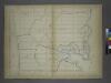
Page 25: [Bounded by W. 211th Street, Harlem Creek, W. 197th Street and Hudson River.]
from Sackersdorf Farm Set.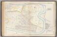
Pl. 45: ward 12.
1 : 3600 Bromley, George Washington; Bromley, Walter Scott
Fort Washington section.
From Manhattan
Part of Section 8 : New York City.
from Atlas of the city of New York, borough of Manhattan. From actual surveys and official plans / by George W. and Walter S. Bromley.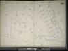
Manhattan, V. 11 1/2, Double Page Plate No. 251 [Map bounded by W. 211st St., Harlem River, Dyckman St., Prescott Ave.]
From Atlas 42.61. Vol. 11-11 1/2, 1893.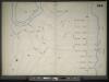
Manhattan, V. 11 1/2, Double Page Plate No. 254 [Map bounded by River St., Harlem River, Prescott Ave.]
From Atlas 42.61. Vol. 11-11 1/2, 1893.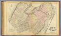
33. Ward 12.
1 : 3600 G.W. Bromley & Co.; Geo. W. Bromley & E. Robinson
Manhattan, V. 11 1/2, Double Page Plate No. 250 [Map bounded by Hudson River, Dyckman St.]
From Atlas 42.61. Vol. 11-11 1/2, 1893.
Part of Section 8 : New York City.
from Atlas of the city of New York, borough of Manhattan. From actual surveys and official plans / by George W. and Walter S. Bromley.
Manhattan, V. 11 1/2, Double Page Plate No. 249 [Map bounded by Broadway, Harlem River, W. 187th St.]
From Atlas 42.61. Vol. 11-11 1/2, 1893.
Property identification map of Inwood Hill. [copy #1 Blue Print, 63 1/2" X 37"] [Copy # 2, Lithograph, Col., 69" X 42"]
From Manhattan
[Plate 49: Bounded by Harlem River (N.Y,C. & H.R.R.R.), Channel Line (U.S. Ship Canal), Prescott Avenue, Emerson Street, Isham Street, Seaman Avenue, Emerson Street, Broadway (Kingsbridge Road), and Dyckman Street.]
from Atlas of the city of New York, borough of Manhattan. From actual surveys and official plans / by George W. and Walter S. Bromley.
Manhattan, V. 12, Plate No. 14 [Map bounded by Academy St., Nagle Ave.]
From Atlas 128. Vol. 12, 1900.
Part of Section 8: Plate 181
from Atlas of the borough of Manhattan, city of New York.
Manhattan, V. 12, Plate No. 15 [Map bounded by Hudson River, Broadway]
From Atlas 128. Vol. 12, 1900.
Plate 179: Bounded by Broadway, Sherman Avenue, Dyckman Street, St Nicholas Avenue and Fairview Avenue.
from Atlas of the borough of Manhattan, city of New York.
Plate 185: Bounded by Nagle Avenue, Amsterdam Avenue, W. 208th Street, Harlem River and (Sherman's Creek) Academy Street.
from Atlas of the borough of Manhattan, city of New York.
Part of Section 8: Plate 180
from Atlas of the borough of Manhattan, city of New York.
Plate 183: Bounded by Nicholas Place, Prescott Avenue, Emerson Place, W. 207th Street, Broadway and Dyckman Street.
from Atlas of the borough of Manhattan, city of New York.
Plate 188: Bounded by W. 214th Street, Columbus Avenue(Harlem River), W. 208th Street, Amsterdam Avenue, Ishan Street and Broadway.
from Atlas of the borough of Manhattan, city of New York.
Part of Section 8: Plate 184
from Atlas of the borough of Manhattan, city of New York.
Manhattan, V. 12, Plate No. 23 [Map bounded by W. 208th St., Harlem River, Academy St., Nagle Ave.]
From Atlas 128. Vol. 12, 1900.
Manhattan, V. 12, Plate No. 13 [Map bounded by Academy St., Nagle Ave., Broadway]
From Atlas 128. Vol. 12, 1900.
[Plate 178: Bounded by Riverside Drive (Hudson River), Corbin Place, Ft. Washington Avenue, Broadway, W. 192nd Street, Overlook Terrace and Northern Avenue. ]
from Atlas of the borough of Manhattan, city of New York.
Manhattan, V. 12, Plate No. 24 [Map bounded by W. 216th St., Harlem River, W. 208th St., 10th Ave.]
From Atlas 128. Vol. 12, 1900.
Manhattan, V. 12, Plate No. 16 [Map bounded by Hudson River, Dyckman St., Broadway]
From Atlas 128. Vol. 12, 1900.
Part of Section 8: Plate 182
from Atlas of the borough of Manhattan, city of New York.
Manhattan, V. 11 1/2, Double Page Plate No. 252 [Map bounded by Bolton Rd., (Un-Named) Road, Hudson River]
From Atlas 42.61. Vol. 11-11 1/2, 1893.
Manhattan, V. 12, Plate No. 22 [Map bounded by Isham St., Nagle Ave., Academy St., Vermilyea Ave.]
From Atlas 128. Vol. 12, 1900.
![Page 25: [Bounded by W. 211th Street, Harlem Creek, W. 197th Street and Hudson River.]](https://images-0.georeferencer.com/images/iiif/403978191190/full/,300/0/native.jpg)

