Maps of Bronx County

Plate 185: Bounded by Nagle Avenue, Amsterdam Avenue, W. 208th Street, Harlem River and (Sherman's Creek) Academy Street.
from Atlas of the borough of Manhattan, city of New York.
Manhattan, V. 12, Plate No. 23 [Map bounded by W. 208th St., Harlem River, Academy St., Nagle Ave.]
From Atlas 128. Vol. 12, 1900.
Manhattan, V. 12, Plate No. 22 [Map bounded by Isham St., Nagle Ave., Academy St., Vermilyea Ave.]
From Atlas 128. Vol. 12, 1900.
Manhattan, V. 12, Plate No. 61 [Map bounded by 10th Ave., W. 210th St., Harlem River, W. 207th St.]
From Atlas 129. Vol. 12, 1913.
Manhattan, V. 12, Plate No. 52 [Map bounded by 10th Ave., W. 204th St., Harlem River, W. 201st St.]
From Atlas 129. Vol. 12, 1913.
Manhattan, V. 12, Plate No. 60 [Map bounded by 10th Ave., W. 207th St., Harlem River, W. 204th St.]
From Atlas 129. Vol. 12, 1913.
Manhattan, V. 12, Plate No. 59 [Map bounded by W. 207th St., Nagle Ave., Academy St., Sherman Ave.]
From Atlas 129. Vol. 12, 1913.
Manhattan, V. 12, Plate No. 51 [Map bounded by Dyckman St., W. 201st St., Harlem River]
From Atlas 129. Vol. 12, 1913.
Manhattan, V. 12, Plate No. 50 [Map bounded by 10th Ave., Dyckman St., Nagle Ave.]
From Atlas 129. Vol. 12, 1913.
Manhattan, V. 12, Plate No. 58 [Map bounded by W. 207th St., Sherman Ave., Academy St., Broadway]
From Atlas 129. Vol. 12, 1913.
Manhattan, V. 12, Plate No. 49 [Map bounded by Vermilyea Ave., Academy St., Nagle Ave., Dyckman St.]
From Atlas 129. Vol. 12, 1913.
Manhattan, V. 12, Plate No. 48 [Map bounded by Dyckman St., Fort George Ave.]
From Atlas 129. Vol. 12, 1913.
Manhattan, V. 11 1/2, Double Page Plate No. 251 [Map bounded by W. 211st St., Harlem River, Dyckman St., Prescott Ave.]
From Atlas 42.61. Vol. 11-11 1/2, 1893.
Part of Section 8: Plate 184
from Atlas of the borough of Manhattan, city of New York.
Part of Section 8: Plate 180
from Atlas of the borough of Manhattan, city of New York.
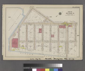
Plate 188: Bounded by W. 214th Street, Columbus Avenue(Harlem River), W. 208th Street, Amsterdam Avenue, Ishan Street and Broadway.
from Atlas of the borough of Manhattan, city of New York.
Plate 56, Part of Section 11, Borough of the Bronx. [Bounded by W. 183rd Street, Aqueduct Avenue East, W. 181st Street, Harrison Avenue, W. 179th Street, Loring Place, W. 180th Street.]
from Atlas of borough of the Bronx, Sections 9 10 11 12 & 13 : from actual surveys and official plans / G.W. Bromley and Co.
Manhattan, V. 12, Plate No. 14 [Map bounded by Academy St., Nagle Ave.]
From Atlas 128. Vol. 12, 1900.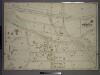
Double Page Plate No. 25, Part of Ward 24, Section 11. [Bounded by Exterior Street, Fordham Road, Aqueduct Avenue and E. 180th Street.]
from Atlas of the borough of the Bronx, city of New York : based upon official plans and maps on file in the various city offices; supplemented by careful field measurements and personal observations, by and under the supervision of Hugo Ullitz.
Manhattan, V. 12, Plate No. 24 [Map bounded by W. 216th St., Harlem River, W. 208th St., 10th Ave.]
From Atlas 128. Vol. 12, 1900.
Manhattan, V. 12, Plate No. 13 [Map bounded by Academy St., Nagle Ave., Broadway]
From Atlas 128. Vol. 12, 1900.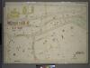
Double Page Plate No. 16, Part of Ward 24, Section 11. [Bounded by Exterior Street, Andrews Avenue and E. 177th Street.]
from Atlas of the borough of the Bronx, city of New York : based upon official plans and maps on file in the various city offices; supplemented by careful field measurements and personal observations, by and under the supervision of Hugo Ullitz.
Plate 179: Bounded by Broadway, Sherman Avenue, Dyckman Street, St Nicholas Avenue and Fairview Avenue.
from Atlas of the borough of Manhattan, city of New York.
Manhattan, V. 12, Plate No. 65 [Map bounded by Broadway, W. 211th St., 10th Ave., Post Ave., W. 207th St.]
From Atlas 129. Vol. 12, 1913.
Manhattan, V. 12, Plate No. 62 [Map bounded by 10th Ave., W. 213th St., Harlem River, W. 210th St.]
From Atlas 129. Vol. 12, 1913.
Manhattan, V. 12, Plate No. 47 [Map bounded by Dyckman St., St. Nicholas Ave., Ellwood St., Nagle Ave.]
From Atlas 129. Vol. 12, 1913.
Manhattan, V. 12, Plate No. 57 [Map bounded by W. 207th St., Broadway, Academy St., Seaman Ave.]
From Atlas 129. Vol. 12, 1913.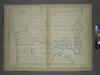
Page 25: [Bounded by W. 211th Street, Harlem Creek, W. 197th Street and Hudson River.]
from Sackersdorf Farm Set.
Fort Washington section.
From Manhattan