Maps of Bronx County

Part of Section 8 : New York City.
from Atlas of the city of New York, borough of Manhattan. From actual surveys and official plans / by George W. and Walter S. Bromley.
Sackersdorff Farm set.
from Maps of farms commonly called the Blue book, 1815 : drawn from the original on file in the street commissioner's office in the City of New York, together with lines of streets and avenues / laid out by John Randel, jr., 1819-20.
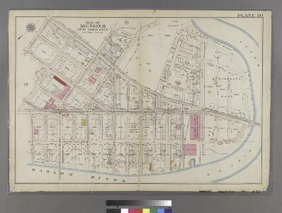
Manhattan, V. 11 1/2, Double Page Plate No. 254 [Map bounded by River St., Harlem River, Prescott Ave.]
From Atlas 42.61. Vol. 11-11 1/2, 1893.
33. Ward 12.
1 : 3600 G.W. Bromley & Co.; Geo. W. Bromley & E. Robinson
Manhattan, V. 11 1/2, Double Page Plate No. 251 [Map bounded by W. 211st St., Harlem River, Dyckman St., Prescott Ave.]
From Atlas 42.61. Vol. 11-11 1/2, 1893.
[Plate 49: Bounded by Harlem River (N.Y,C. & H.R.R.R.), Channel Line (U.S. Ship Canal), Prescott Avenue, Emerson Street, Isham Street, Seaman Avenue, Emerson Street, Broadway (Kingsbridge Road), and Dyckman Street.]
from Atlas of the city of New York, borough of Manhattan. From actual surveys and official plans / by George W. and Walter S. Bromley.
Plate 189: Bounded by Cold Spring Road, Indian Road (Harlem River), Broadway, and W. 215th Street.
from Atlas of the borough of Manhattan, city of New York.
Manhattan, V. 12, Plate No. 20 [Map bounded by Harlem River, Seaman Ave.]
From Atlas 128. Vol. 12, 1900.
Plate 190: Bounded by Broadway, Columbus Avenue (Harlem River) and W. 214th Street.
from Atlas of the borough of Manhattan, city of New York.
Plate 188: Bounded by W. 214th Street, Columbus Avenue(Harlem River), W. 208th Street, Amsterdam Avenue, Ishan Street and Broadway.
from Atlas of the borough of Manhattan, city of New York.
Part of Section 8: Plate 187
from Atlas of the borough of Manhattan, city of New York.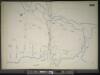
Manhattan, V. 11 1/2, Double Page Plate No. 255 [Map bounded by River St., Harlem River, W. 215th St.]
From Atlas 42.61. Vol. 11-11 1/2, 1893.
Part of Section 8: Plate 184
from Atlas of the borough of Manhattan, city of New York.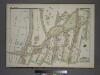
Plate 62, Part of Section 11, Borough of the Bronx. [Bounded by E. Harlem River Terrace, W. fordham Road, Cedar Avenue, W. 182ndStreet, Sedgwick Avenue, W. 183rd Street, Aqueduct Avenue East, W. 184th Street, Grand Avenue and W. 188th Street.]
from Atlas of borough of the Bronx, Sections 9 10 11 12 & 13 : from actual surveys and official plans / G.W. Bromley and Co.
Manhattan, V. 12, Plate No. 24 [Map bounded by W. 216th St., Harlem River, W. 208th St., 10th Ave.]
From Atlas 128. Vol. 12, 1900.
Manhattan, V. 12, Plate No. 26 [Map bounded by Seaman Ave., Harlem River, 9th Ave., W. 216th St.]
From Atlas 128. Vol. 12, 1900.
Manhattan, V. 12, Plate No. 22 [Map bounded by Isham St., Nagle Ave., Academy St., Vermilyea Ave.]
From Atlas 128. Vol. 12, 1900.
Plate 185: Bounded by Nagle Avenue, Amsterdam Avenue, W. 208th Street, Harlem River and (Sherman's Creek) Academy Street.
from Atlas of the borough of Manhattan, city of New York.
Manhattan, V. 12, Plate No. 23 [Map bounded by W. 208th St., Harlem River, Academy St., Nagle Ave.]
From Atlas 128. Vol. 12, 1900.
Manhattan, V. 12, Plate No. 29 [Map bounded by Harlem River, Spuyten Duyvil Creek]
From Atlas 128. Vol. 12, 1900.
Manhattan, V. 12, Plate No. 63 [Map bounded by Cold Spring Rd., Crosby Place]
From Atlas 129. Vol. 12, 1913.
Manhattan, V. 12, Plate No. 72 [Map bounded by Harlem River, Seaman Ave., W. 218th St.]
From Atlas 129. Vol. 12, 1913.
Manhattan, V. 12, Plate No. 80 [Map bounded byW. 227th St., Broadway, W. 225th St., Van Corlears Place]
From Atlas 129. Vol. 12, 1913.
Manhattan, V. 12, Plate No. 61 [Map bounded by 10th Ave., W. 210th St., Harlem River, W. 207th St.]
From Atlas 129. Vol. 12, 1913.
Manhattan, V. 12, Plate No. 60 [Map bounded by 10th Ave., W. 207th St., Harlem River, W. 204th St.]
From Atlas 129. Vol. 12, 1913.
Manhattan, V. 12, Plate No. 67 [Map bounded by 10th Ave., W. 216th St., Harlem River, W. 213th St.]
From Atlas 129. Vol. 12, 1913.
Manhattan, V. 12, Plate No. 66 [Map bounded by W. 215th St., 10th Ave., W. 211th St., Broadway]
From Atlas 129. Vol. 12, 1913.
Manhattan, V. 12, Plate No. 74 [Map bounded by Harlem River, W. 218th St., Seaman Ave., W. 213th St.]
From Atlas 129. Vol. 12, 1913.
Manhattan, V. 12, Plate No. 62 [Map bounded by 10th Ave., W. 213th St., Harlem River, W. 210th St.]
From Atlas 129. Vol. 12, 1913.