Maps of Bronx County
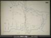
Manhattan, V. 11 1/2, Double Page Plate No. 255 [Map bounded by River St., Harlem River, W. 215th St.]
From Atlas 42.61. Vol. 11-11 1/2, 1893.
Part of Section 8: Plate 191
from Atlas of the borough of Manhattan, city of New York.
Plate 189: Bounded by Cold Spring Road, Indian Road (Harlem River), Broadway, and W. 215th Street.
from Atlas of the borough of Manhattan, city of New York.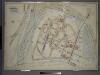
Atlas of the borough of the Bronx, city of New York : based upon official plans and maps on file in the various city offices; supplemented by careful field measurements and personal observations, by and under the supervision of Hugo Ullitz.
from Atlas of the borough of the Bronx, city of New York : based upon official plans and maps on file in the various city offices; supplemented by careful field measurements and personal observations, by and under the supervision of Hugo Ullitz.
Plate 190: Bounded by Broadway, Columbus Avenue (Harlem River) and W. 214th Street.
from Atlas of the borough of Manhattan, city of New York.
Manhattan, V. 12, Plate No. 27 [Map bounded by Spuyten Duyvil Creek, Broadway, Harlem River]
From Atlas 128. Vol. 12, 1900.
Manhattan, V. 12, Plate No. 26 [Map bounded by Seaman Ave., Harlem River, 9th Ave., W. 216th St.]
From Atlas 128. Vol. 12, 1900.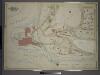
Atlas of the borough of the Bronx, city of New York : based upon official plans and maps on file in the various city offices; supplemented by careful field measurements and personal observations, by and under the supervision of Hugo Ullitz.
from Atlas of the borough of the Bronx, city of New York : based upon official plans and maps on file in the various city offices; supplemented by careful field measurements and personal observations, by and under the supervision of Hugo Ullitz.
Manhattan, V. 12, Plate No. 29 [Map bounded by Harlem River, Spuyten Duyvil Creek]
From Atlas 128. Vol. 12, 1900.
Manhattan, V. 12, Plate No. 28 [Map bounded by Johnson Ave., W. 232nd St., Broadway, W. 230th St.]
From Atlas 128. Vol. 12, 1900.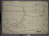
Double Page Plate No. 33, Part of Ward 24, Sections 11&12. [Bounded by Broadway, E. 230th Street, Bailey Avenue, Boston Avenue, Sedgwick Avenue, Kingsbridge Rpad. Emmerich Place, Bailey Avenue and E. 192nd Street.]
from Atlas of the borough of the Bronx, city of New York : based upon official plans and maps on file in the various city offices; supplemented by careful field measurements and personal observations, by and under the supervision of Hugo Ullitz.
Bronx, V. 13, Plate No. 4 [Map bounded by W. 227th St., Old Kingsbridge Rd., Kappock St., Arlington Ave.]
From Atlas 51.1. Vol. 13, 1914.
Manhattan, V. 12, Plate No. 82 [Map bounded by W. 230th St., Broadway, W. 227th St.]
From Atlas 129. Vol. 12, 1913.
Manhattan, V. 12, Plate No. 72 [Map bounded by Harlem River, Seaman Ave., W. 218th St.]
From Atlas 129. Vol. 12, 1913.
Manhattan, V. 12, Plate No. 81 [Map bounded by Broadway, W. 225th St., Harlem River]
From Atlas 129. Vol. 12, 1913.
Manhattan, V. 12, Plate No. 79 [Map bounded by W. 227th St., Jacobus Place., Harlem River, Teunissen Ave.]
From Atlas 129. Vol. 12, 1913.
Manhattan, V. 12, Plate No. 80 [Map bounded byW. 227th St., Broadway, W. 225th St., Van Corlears Place]
From Atlas 129. Vol. 12, 1913.
Manhattan, V. 12, Plate No. 67 [Map bounded by 10th Ave., W. 216th St., Harlem River, W. 213th St.]
From Atlas 129. Vol. 12, 1913.
Manhattan, V. 12, Plate No. 66 [Map bounded by W. 215th St., 10th Ave., W. 211th St., Broadway]
From Atlas 129. Vol. 12, 1913.
Manhattan, V. 12, Plate No. 68 [Map bounded by 10th Ave., Broadway, W. 219th St., Harlem River, W. 216th St.]
From Atlas 129. Vol. 12, 1913.
Manhattan, V. 12, Plate No. 77 [Map bounded by Seaman Ave., Harlem River, Broadway, W. 219th St.]
From Atlas 129. Vol. 12, 1913.
Manhattan, V. 12, Plate No. 76 [Map bounded by Seaman Ave., W. 219th St., Broadway]
From Atlas 129. Vol. 12, 1913.
Manhattan, V. 12, Plate No. 78 [Map bounded by Broadway, Harlem River, W. 219th St.]
From Atlas 129. Vol. 12, 1913.
Manhattan, V. 12, Plate No. 75 [Map bounded by Seaman Ave., W. 217th St., Broadway, W. 214th St.]
From Atlas 129. Vol. 12, 1913.
Manhattan, V. 12, Plate No. 20 [Map bounded by Harlem River, Seaman Ave.]
From Atlas 128. Vol. 12, 1900.
Manhattan, V. 12, Plate No. 64 [Map bounded by W. 214th St., Broadway, W. 207th St., Seaman Ave.]
From Atlas 129. Vol. 12, 1913.
Part of Section 8: Plate 187
from Atlas of the borough of Manhattan, city of New York.
Manhattan, V. 12, Plate No. 74 [Map bounded by Harlem River, W. 218th St., Seaman Ave., W. 213th St.]
From Atlas 129. Vol. 12, 1913.
Manhattan, V. 12, Plate No. 65 [Map bounded by Broadway, W. 211th St., 10th Ave., Post Ave., W. 207th St.]
From Atlas 129. Vol. 12, 1913.
![Manhattan, V. 11 1/2, Double Page Plate No. 255 [Map bounded by River St., Harlem River, W. 215th St.]](https://images-2.georeferencer.com/images/iiif/403794348414/full/,300/0/native.jpg)

