Maps of Bergen County

Manhattan, V. 12, Plate No. 13 [Map bounded by Academy St., Nagle Ave., Broadway]
From Atlas 128. Vol. 12, 1900.
Plate 179: Bounded by Broadway, Sherman Avenue, Dyckman Street, St Nicholas Avenue and Fairview Avenue.
from Atlas of the borough of Manhattan, city of New York.
Part of Section 8: Plate 181
from Atlas of the borough of Manhattan, city of New York.
Manhattan, V. 12, Plate No. 45 [Map bounded by Dyckman St., Sherman Ave., Broadway]
From Atlas 129. Vol. 12, 1913.
Manhattan, V. 12, Plate No. 49 [Map bounded by Vermilyea Ave., Academy St., Nagle Ave., Dyckman St.]
From Atlas 129. Vol. 12, 1913.
Manhattan, V. 12, Plate No. 46 [Map bounded by Dyckman St., Nagle Ave., Ellwood St., Sherman Ave.]
From Atlas 129. Vol. 12, 1913.
Manhattan, V. 12, Plate No. 41 [Map bounded by Riverside Drive, Broadway, Corbin Place]
From Atlas 129. Vol. 12, 1913.
Manhattan, V. 12, Plate No. 37 [Map bounded by Ellwood St., Nagle Ave., Broadway]
From Atlas 129. Vol. 12, 1913.
Manhattan, V. 12, Plate No. 42 [Map bounded by D. St., Dyckman St., Riverside Drive]
From Atlas 129. Vol. 12, 1913.
Manhattan, V. 12, Plate No. 44 [Map bounded by Prescott Ave., Academy St., Vermilyea Ave., Dyckman St.]
From Atlas 129. Vol. 12, 1913.
Manhattan, V. 12, Plate No. 36 [Map bounded by Riverside Drive, Broadway]
From Atlas 129. Vol. 12, 1913.
Manhattan, V. 12, Plate No. 47 [Map bounded by Dyckman St., St. Nicholas Ave., Ellwood St., Nagle Ave.]
From Atlas 129. Vol. 12, 1913.
Manhattan, V. 12, Plate No. 50 [Map bounded by 10th Ave., Dyckman St., Nagle Ave.]
From Atlas 129. Vol. 12, 1913.
Manhattan, V. 12, Plate No. 58 [Map bounded by W. 207th St., Sherman Ave., Academy St., Broadway]
From Atlas 129. Vol. 12, 1913.
Manhattan, V. 12, Plate No. 48 [Map bounded by Dyckman St., Fort George Ave.]
From Atlas 129. Vol. 12, 1913.
Part of Section 8 : New York City.
from Atlas of the city of New York, borough of Manhattan. From actual surveys and official plans / by George W. and Walter S. Bromley.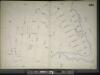
Manhattan, V. 11 1/2, Double Page Plate No. 251 [Map bounded by W. 211st St., Harlem River, Dyckman St., Prescott Ave.]
From Atlas 42.61. Vol. 11-11 1/2, 1893.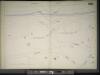
Manhattan, V. 11 1/2, Double Page Plate No. 250 [Map bounded by Hudson River, Dyckman St.]
From Atlas 42.61. Vol. 11-11 1/2, 1893.
Part of Section 8: Plate 184
from Atlas of the borough of Manhattan, city of New York.
Manhattan, V. 12, Plate No. 16 [Map bounded by Hudson River, Dyckman St., Broadway]
From Atlas 128. Vol. 12, 1900.
[Plate 178: Bounded by Riverside Drive (Hudson River), Corbin Place, Ft. Washington Avenue, Broadway, W. 192nd Street, Overlook Terrace and Northern Avenue. ]
from Atlas of the borough of Manhattan, city of New York.
Manhattan, V. 12, Plate No. 14 [Map bounded by Academy St., Nagle Ave.]
From Atlas 128. Vol. 12, 1900.
Plate 183: Bounded by Nicholas Place, Prescott Avenue, Emerson Place, W. 207th Street, Broadway and Dyckman Street.
from Atlas of the borough of Manhattan, city of New York.
Manhattan, V. 12, Plate No. 15 [Map bounded by Hudson River, Broadway]
From Atlas 128. Vol. 12, 1900.
Part of Section 8: Plate 180
from Atlas of the borough of Manhattan, city of New York.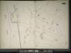
Manhattan, V. 11 1/2, Double Page Plate No. 252 [Map bounded by Bolton Rd., (Un-Named) Road, Hudson River]
From Atlas 42.61. Vol. 11-11 1/2, 1893.
Manhattan, V. 12, Plate No. 22 [Map bounded by Isham St., Nagle Ave., Academy St., Vermilyea Ave.]
From Atlas 128. Vol. 12, 1900.
Manhattan, V. 12, Plate No. 23 [Map bounded by W. 208th St., Harlem River, Academy St., Nagle Ave.]
From Atlas 128. Vol. 12, 1900.
Plate 185: Bounded by Nagle Avenue, Amsterdam Avenue, W. 208th Street, Harlem River and (Sherman's Creek) Academy Street.
from Atlas of the borough of Manhattan, city of New York.
![Manhattan, V. 12, Plate No. 13 [Map bounded by Academy St., Nagle Ave., Broadway]](https://images-2.georeferencer.com/images/iiif/909235575623/full/,300/0/native.jpg)

