Maps of Kings County

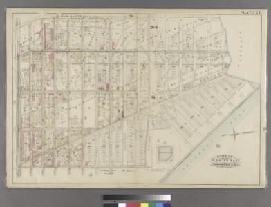
Plate 27: Part of Wards 9 & 24. Brooklyn, N.Y.
from Robinson's atlas of the city of Brooklyn, New York : embracing all territory within its corporate limits; from official records ... / by and under the supervision of E. Robinson and R.H. Pidgeon, civil engineers.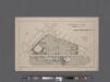
University Park, Brooklyn, N. Y., general improvement plan.
From Brooklyn
Plate 11: Part of Wards 9 & 24. City of Brooklyn.
from Atlas of the entire city of Brooklyn, complete in one volume. From actual surveys and official records by G. W. Bromley & Co.
Part of Wards 9, 22 . Land Map Section, No. 4 , Volume 1, Brooklyn Borough, New York City.
from Atlas of the Brooklyn borough of the City of New York : originally Kings Co.; complete in three volumes ... based upon official maps and plans ... / by and under the supervision of Hugo Ullitz, C.E.
Brooklyn, Vol. 1, Double Page Plate No. 15; Part of Wards 9, 22 & 29, Section 4; [Map bounded by Atlantic Ave., Franklin Ave., Carroll St., Institute Park, Flatbush Ave., Plaza, Prospect Park Ave.; Including Carroll St., 7th Ave., Flatbush Ave., Carlt...
From Volume 1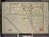
Brooklyn, Vol. 1, Double Page Plate No. 18; Part of Ward 9, Section 4; [Map bounded by Sterling PL., Franklin Ave., Crown St., Washington Ave.; Including Flatbush Ave., Eastern Parkway, Underhill Ave.]
from Wards 1, 2, 3, 4, 5, 6, 8, 9, 10, 12 & 22.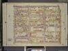
Brooklyn, Vol. 1, Double Page Plate No. 17; Part of Ward 9, Section 4; [Map bounded by Atlantic Ave., Franklin Ave.; Including Sterling PL., Underhill Ave.]
from Wards 1, 2, 3, 4, 5, 6, 8, 9, 10, 12 & 22.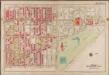
Plate 27: [Bounded by Bedford Avenue, Malbone Street, (Prospect Park) Flatbush Avenue, Eastern Parkway, Underhill Avenue and Atlantic Avenue.]; Atlas of the borough of Brooklyn, city of New York: from actual surveys and official plans by George W. and Walter S. Bromley.
from Atlas of the borough of Brooklyn, city of New York : from actual surveys and official plans by George W. and Walter S. Bromley. G.W. Bromley & Co.,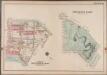
Plate 36: Prospect Park [Bounded by (Institute Park) Flatbush Avenue, Ocean Avenue, Caton Avenue, Coney Island Avenue, Seeley Avenue, Prospect Avenue, Terrace Place, (Greenwood Cemetery) Gavesend Avenue, 20th Street and Prospect Park West.]; Atlas of the borough of Brooklyn, city of New York: from actual surveys and official plans by George W. and Walter S. Bromley.
from Atlas of the borough of Brooklyn, city of New York : from actual surveys and official plans by George W. and Walter S. Bromley. G.W. Bromley & Co.,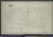
Vol. 1. Plate, M. [Map bound by Roges Ave., City Line, Franklin Ave., Park PL; Including Bedford Ave., Butler St., Douglass St., Degraw St., Eastern Parkway, Union St., President St., Carroll St., Crown St., Montgomery St.]
from Detailed estate and old farm line atlas of the city of Brooklyn : complete in six volumes ... from official records, private plans, and actual surveys ... / by G.M. Hopkins, C.E.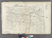
Plate 10: Part of Wards 7, 9, 23 & 24.
from Atlas of the entire city of Brooklyn, complete in one volume. From actual surveys and official records by G. W. Bromley & Co.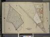
Brooklyn, vol. 1, Double Page Plate No. 19; Part of Wards 9 & 29, Section 4; [Map bounded by crown St., Franklin Ave., Flatbush Ave.; Including Washington Ave.]; Sub Plan; [Map bounded by Flatbush Ave., Ocean Ave., Caton Ave.; Including
from Wards 1, 2, 3, 4, 5, 6, 8, 9, 10, 12 & 22.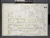
Brooklyn, V. 6, Double Page Plate No. 155 [Map bounded by Prospect Place, Underhill Ave., Atlantic Ave., Classon Ave.]
From Atlas 80. Vol. 6, 1888.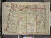
Brooklyn, Vol. 2, Double Page Plate No. 25; Part of Ward 24, Section 5; [Map bounded by St. Johns PL. (Douglass St.); Including New York Ave., Montgomery St., Franklin Ave.]
from Wards 7, 11, 20, 21, 23, 24 & 25.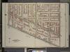
Brooklyn, Vol. 2, Double Page Plate No. 7; Part of Wards 7 & 23, Section 7; [Map bounded by Gates Ave., Bedford Ave.; Including Atlantic Ave., Washington Ave.]
from Wards 7, 11, 20, 21, 23, 24 & 25.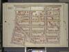
Brooklyn, Vol. 1, Double Page Plate No. 16; Part of Ward 9, Section 4; [Map bounded by Atlantic Ave., Underhill Ave., Sterling PL., St. John PL.; Including Flatbush Ave., 7th Ave, 6th Ave.]
from Wards 1, 2, 3, 4, 5, 6, 8, 9, 10, 12 & 22.
Brooklyn, V. 6, Double Page Plate No. 149 [Map bounded by Prospect Place, Carlton Ave., Atlantic Ave., Underhill Ave.]
From Atlas 80. Vol. 6, 1888.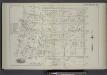
Vol. 1. Plate, H. [Map bound by Atlantic Ave., New York Ave., Butler St., Park Pl., Franklin Ave.; Including Pacific St., Dean St., Bergen St., St. Marks Ave., Prospect Pl., Bedford Ave., Rogers Ave., Nostrand Ave.]
from Detailed estate and old farm line atlas of the city of Brooklyn : complete in six volumes ... from official records, private plans, and actual surveys ... / by G.M. Hopkins, C.E.
Brooklyn V. 7, Plate No. 4 [Map bounded by Atlantic Ave., Nostrand Ave., St. Marks Ave., Bedford Ave.]
From Atlas 84. Vol. 7, 1904.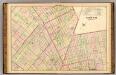
Sec. 5. Brooklyn map.
1 : 6000 Fulton, Henry; J.B. Beers & Co.
Sec. 10. Brooklyn map.
1 : 6000 Fulton, Henry; J.B. Beers & Co.
[Plate 6: Bounded by Washington Avenue, Underhill Avenue, Parkway, Ninth Avenue, President Street, Fifth Avenue, Atlantic Avenue, Portland Avenue, Hanson Place, Greene Avenue, Clermont Avenue and Lafayette Avenue.]
from Atlas of the city of Brooklyn, New York.
Plate 26: Bounded by Kingston Avenue, Malabone Street, New York Avenue, Montgomery Street, Rogers Avenue, Crown Street, Bedford Avenue and Herkimer Street.
from Robinson's atlas of the city of Brooklyn, New York : embracing all territory within its corporate limits; from official records ... / by and under the supervision of E. Robinson and R.H. Pidgeon, civil engineers.
Brooklyn, Vol. 1, Double Page Plate No. 17; Part of Ward 24, Section 5; [Map bounded by Atlantic Ave., Albany Ave., Eastern Parkway, Franklin Ave.] / by and under the direction of Hugo Ullitz.
From Volume 1
Brooklyn V. 2, Double Page Plate No. 51 [Map bounded by Clermont Ave., Atlantic Ave., S.Portland Ave., Lafayette Ave.]
From Atlas 66. Vol. 2, 1887.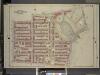
Brooklyn, Vol. 1, Double Page Plate No. 20; Part of Wards 9 & 22, Section 4; [Map bounded by Sterling PL., Underhil Ave., Eastern Parkway, Prospect Park West; Including Garfield PL., 6th Ave., St. Johns PL., 7th Ave., Flatbush Ave.]
from Wards 1, 2, 3, 4, 5, 6, 8, 9, 10, 12 & 22.
Part of Ward 24. Land Map Section, No. 5, Volume 1, Brooklyn Borough, New York City.
from Atlas of the Brooklyn borough of the City of New York : originally Kings Co.; complete in three volumes ... based upon official maps and plans ... / by and under the supervision of Hugo Ullitz, C.E.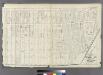
Plate 12: Part of Ward 22. City of Brooklyn.
from Atlas of the entire city of Brooklyn, complete in one volume. From actual surveys and official records by G. W. Bromley & Co.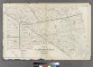
Plate 9: Part of Wards 3, 9, 10, 11, 20 & 22. City of Brooklyn.
from Atlas of the entire city of Brooklyn, complete in one volume. From actual surveys and official records by G. W. Bromley & Co.