Maps of Kings County
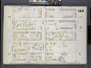
Brooklyn, V. 6, Double Page Plate No. 149 [Map bounded by Prospect Place, Carlton Ave., Atlantic Ave., Underhill Ave.]
From Atlas 80. Vol. 6, 1888.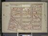
Brooklyn, Vol. 1, Double Page Plate No. 16; Part of Ward 9, Section 4; [Map bounded by Atlantic Ave., Underhill Ave., Sterling PL., St. John PL.; Including Flatbush Ave., 7th Ave, 6th Ave.]
from Wards 1, 2, 3, 4, 5, 6, 8, 9, 10, 12 & 22.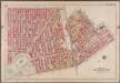
Plate 6: [Bounded by Fifth Avenue, Atlantic Avenue, S. Portland Avenue, Hanson Place, Greene Avenue, Clermont Avenue, Lafayette Avenue, Washington Avenue, Underhill Avenue, Eastern Parkway, Prospect Park West and President Street.]; Atlas of the borough of Brooklyn, city of New York: from actual surveys and official plans by George W. and Walter S. Bromley.
from Atlas of the borough of Brooklyn, city of New York : from actual surveys and official plans by George W. and Walter S. Bromley. G.W. Bromley & Co.,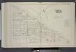
Vol. 4. Plate, A. [Map bound by Atlantic Ave., Flatbush Ave., St. Johns Place, Douglass St., Fourth Ave.; Including Pacific St., Dean St., Berg St., Wyckoff St., St. Marks Ave., Warren St., Prospect Pl., Baltic St., Park Pl., Butler St., Sterling Pl., Fi
from Detailed estate and old farm line atlas of the city of Brooklyn : complete in six volumes ... from official records, private plans, and actual surveys ... / by G.M. Hopkins, C.E.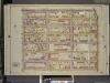
Brooklyn, Vol. 1, Double Page Plate No. 17; Part of Ward 9, Section 4; [Map bounded by Atlantic Ave., Franklin Ave.; Including Sterling PL., Underhill Ave.]
from Wards 1, 2, 3, 4, 5, 6, 8, 9, 10, 12 & 22.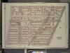
Brooklyn, Vol. 2, Double Page Plate No. 3; Part of Ward 20, Section 7; [Map bounded by Washington Ave., Atlantic Ave.; Including South Oxford St., De Kalb Ave.]
from Wards 7, 11, 20, 21, 23, 24 & 25.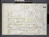
Brooklyn, V. 6, Double Page Plate No. 155 [Map bounded by Prospect Place, Underhill Ave., Atlantic Ave., Classon Ave.]
From Atlas 80. Vol. 6, 1888.
Part of Wards 9, 22 . Land Map Section, No. 4 , Volume 1, Brooklyn Borough, New York City.
from Atlas of the Brooklyn borough of the City of New York : originally Kings Co.; complete in three volumes ... based upon official maps and plans ... / by and under the supervision of Hugo Ullitz, C.E.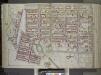
Brooklyn, Vol. 1, Double Page Plate No. 15; Part of Wards 9, 22 & 29, Section 4; [Map bounded by Atlantic Ave., Franklin Ave., Carroll St., Institute Park, Flatbush Ave., Plaza, Prospect Park Ave.; Including Carroll St., 7th Ave., Flatbush Ave., Carlt...
From Volume 1
[Plate 6: Bounded by Washington Avenue, Underhill Avenue, Parkway, Ninth Avenue, President Street, Fifth Avenue, Atlantic Avenue, Portland Avenue, Hanson Place, Greene Avenue, Clermont Avenue and Lafayette Avenue.]
from Atlas of the city of Brooklyn, New York.
Double Page Plate No. 27: [Bounded by Willoughby Avenue, Steuben Street, Lafayette Avenue, Grand Avenue, Atlantic Ave (Jamaica Turnpike), Flatbush Avenue, Fulton Street, (Fort Green) Dekalb Avenue and Washington Park.
from Atlas of the Brooklyn borough of the City of New York : originally Kings Co.; complete in three volumes ... based upon official maps and plans ... / by and under the supervision of Hugo Ullitz, C.E.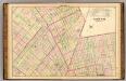
Sec. 5. Brooklyn map.
1 : 6000 Fulton, Henry; J.B. Beers & Co.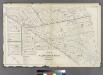
Plate 9: Part of Wards 3, 9, 10, 11, 20 & 22. City of Brooklyn.
from Atlas of the entire city of Brooklyn, complete in one volume. From actual surveys and official records by G. W. Bromley & Co.
University Park, Brooklyn, N. Y., general improvement plan.
From Brooklyn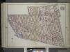
Brooklyn, Vol. 1, Double Page Plate No. 27; Part of Wards 7-11, 20 Section 7; [Map bounded by Willoughby Ave., Steuben St., Lafayette Ave., Grand Ave., Atlantic Ave.; Including Flatbush Ave., Fulton St., Hudson Ave., De Kalb Ave., Washington Park] / b...
From Volume 1
Plate 27: Part of Wards 9 & 24. Brooklyn, N.Y.
from Robinson's atlas of the city of Brooklyn, New York : embracing all territory within its corporate limits; from official records ... / by and under the supervision of E. Robinson and R.H. Pidgeon, civil engineers.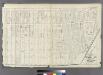
Plate 12: Part of Ward 22. City of Brooklyn.
from Atlas of the entire city of Brooklyn, complete in one volume. From actual surveys and official records by G. W. Bromley & Co.
Part of Wards 9, 22 . Land Map Section, No. 4 , Volume 1, Brooklyn Borough, New York City.
from Atlas of the Brooklyn borough of the City of New York : originally Kings Co.; complete in three volumes ... based upon official maps and plans ... / by and under the supervision of Hugo Ullitz, C.E.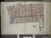
Brooklyn, Vol. 1, Double Page Plate No. 14; Part of Wards 9 & 22, Section 4; [Map bounded by 7th Ave., 3rd St., Gowanus Canal, Lateral Canal; Including 1st St., 4th Ave., Atlantic Ave., Carlton Ave., Flatbush Ave.] / by and under the direction of Hugo...
From Volume 1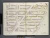
Brooklyn V. 2, Double Page Plate No. 51 [Map bounded by Clermont Ave., Atlantic Ave., S.Portland Ave., Lafayette Ave.]
From Atlas 66. Vol. 2, 1887.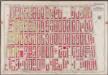
Plate 28: [Bounded by Fourth Avenue, President Street, Prospect Park West and Prospect Avenue.]; Atlas of the borough of Brooklyn, city of New York: from actual surveys and official plans by George W. and Walter S. Bromley.
from Atlas of the borough of Brooklyn, city of New York : from actual surveys and official plans by George W. and Walter S. Bromley. G.W. Bromley & Co.,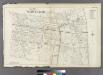
Plate 10: Part of Wards 7, 9, 23 & 24.
from Atlas of the entire city of Brooklyn, complete in one volume. From actual surveys and official records by G. W. Bromley & Co.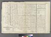
Plate 8: Part of Wards 7, 20, 21& 23. City of Brooklyn.
from Atlas of the entire city of Brooklyn, complete in one volume. From actual surveys and official records by G. W. Bromley & Co.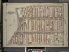
Brooklyn, Vol. 1, Double page Plate No. 15; Part of Wards 3, 9 & 10, Section 1, 2 & 4; [Map bounded by 6th Ave., Berkeley PL., Sackett St.; Including 3rd Ave., Flatbush Ave, Atlantic Ave.]
from Wards 1, 2, 3, 4, 5, 6, 8, 9, 10, 12 & 22.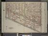
Brooklyn, Vol. 2, Double Page Plate No. 7; Part of Wards 7 & 23, Section 7; [Map bounded by Gates Ave., Bedford Ave.; Including Atlantic Ave., Washington Ave.]
from Wards 7, 11, 20, 21, 23, 24 & 25.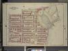
Brooklyn, Vol. 1, Double Page Plate No. 20; Part of Wards 9 & 22, Section 4; [Map bounded by Sterling PL., Underhil Ave., Eastern Parkway, Prospect Park West; Including Garfield PL., 6th Ave., St. Johns PL., 7th Ave., Flatbush Ave.]
from Wards 1, 2, 3, 4, 5, 6, 8, 9, 10, 12 & 22.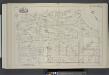
Vol. 4. Plate, B. [Map bound by St. Johns Place, PLaza, Ninth Ave., First St., Fifth Ave.; Including Lincoln Place, Sackett St., Union St., President St., Carroll St., Macomb St., Sixth Ave., Seventh Ave., Polhemus Pl., Fiske Pl., Eighth Ave.]
from Detailed estate and old farm line atlas of the city of Brooklyn : complete in six volumes ... from official records, private plans, and actual surveys ... / by G.M. Hopkins, C.E.
Plate 7: Bounded by Lafayette Avenue, Marcy Avenue, Greene Avenue, Tompkins Avenue, Fulton Street, Brooklyn Avenue, Herkimer Street, Bedford Avenue, Atlantic Avenue and Washington Avenue.
from Robinson's atlas of the city of Brooklyn, New York : embracing all territory within its corporate limits; from official records ... / by and under the supervision of E. Robinson and R.H. Pidgeon, civil engineers.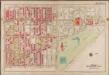
Plate 27: [Bounded by Bedford Avenue, Malbone Street, (Prospect Park) Flatbush Avenue, Eastern Parkway, Underhill Avenue and Atlantic Avenue.]; Atlas of the borough of Brooklyn, city of New York: from actual surveys and official plans by George W. and Walter S. Bromley.
from Atlas of the borough of Brooklyn, city of New York : from actual surveys and official plans by George W. and Walter S. Bromley. G.W. Bromley & Co.,
![Brooklyn, V. 6, Double Page Plate No. 149 [Map bounded by Prospect Place, Carlton Ave., Atlantic Ave., Underhill Ave.]](https://images-2.georeferencer.com/images/iiif/706601185719/full/,300/0/native.jpg)

