Maps of Kings County
Plate 12: Part of Ward 22. City of Brooklyn.
from Atlas of the entire city of Brooklyn, complete in one volume. From actual surveys and official records by G. W. Bromley & Co.
Plate 28: [Bounded by Fourth Avenue, President Street, Prospect Park West and Prospect Avenue.]; Atlas of the borough of Brooklyn, city of New York: from actual surveys and official plans by George W. and Walter S. Bromley.
from Atlas of the borough of Brooklyn, city of New York : from actual surveys and official plans by George W. and Walter S. Bromley. G.W. Bromley & Co.,
Plate 28: Part of Ward 22. Brooklyn, N.Y.
from Atlas of the city of Brooklyn, New York.
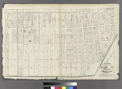
Part of Wards 9, 22 . Land Map Section, No. 4 , Volume 1, Brooklyn Borough, New York City.
from Atlas of the Brooklyn borough of the City of New York : originally Kings Co.; complete in three volumes ... based upon official maps and plans ... / by and under the supervision of Hugo Ullitz, C.E.
Vol. 4. Plate, E. [Map bound by First St., Ninth Ave., Tenth St., Fifth Ave.; Including Second St., Third St., Fourth St., Fifth St., Sixth St., Seventh St., Eighth St., Ninth St., Sixth Ave., Seventh Ave., Eighth Ave.]
from Detailed estate and old farm line atlas of the city of Brooklyn : complete in six volumes ... from official records, private plans, and actual surveys ... / by G.M. Hopkins, C.E.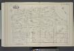
Vol. 4. Plate, B. [Map bound by St. Johns Place, PLaza, Ninth Ave., First St., Fifth Ave.; Including Lincoln Place, Sackett St., Union St., President St., Carroll St., Macomb St., Sixth Ave., Seventh Ave., Polhemus Pl., Fiske Pl., Eighth Ave.]
from Detailed estate and old farm line atlas of the city of Brooklyn : complete in six volumes ... from official records, private plans, and actual surveys ... / by G.M. Hopkins, C.E.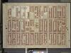
Brooklyn, Vol. 1, Double Page Plate No. 21; Part of Ward 22, Section 4; [Map bounded by Prospect Park West, 13th St.; Including 6th Ave., Carfield PL.]
from Wards 1, 2, 3, 4, 5, 6, 8, 9, 10, 12 & 22.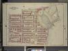
Brooklyn, Vol. 1, Double Page Plate No. 20; Part of Wards 9 & 22, Section 4; [Map bounded by Sterling PL., Underhil Ave., Eastern Parkway, Prospect Park West; Including Garfield PL., 6th Ave., St. Johns PL., 7th Ave., Flatbush Ave.]
from Wards 1, 2, 3, 4, 5, 6, 8, 9, 10, 12 & 22.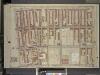
Brooklyn, Vol. 1, Double Page Plate No. 22; Part of Ward 22, Section 2 & 4; [Map bounded by 6th Ave., 8th Ave.; Including 3rd Ave., Sackett St., Berkeley PL.]
from Wards 1, 2, 3, 4, 5, 6, 8, 9, 10, 12 & 22.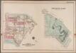
Plate 36: Prospect Park [Bounded by (Institute Park) Flatbush Avenue, Ocean Avenue, Caton Avenue, Coney Island Avenue, Seeley Avenue, Prospect Avenue, Terrace Place, (Greenwood Cemetery) Gavesend Avenue, 20th Street and Prospect Park West.]; Atlas of the borough of Brooklyn, city of New York: from actual surveys and official plans by George W. and Walter S. Bromley.
from Atlas of the borough of Brooklyn, city of New York : from actual surveys and official plans by George W. and Walter S. Bromley. G.W. Bromley & Co.,
Vol. 4. Plate, C. [Map bound by Fifth Ave., Fifth St., Sixth St., Second Ave., Gowanus Canal, First St., Fourth Ave., Douglass Ave.; Including Third Ave., Degraw St., Sackett St., Union St., President St., Carroll St., Comb St., Second St., Third St., Fo
from Detailed estate and old farm line atlas of the city of Brooklyn : complete in six volumes ... from official records, private plans, and actual surveys ... / by G.M. Hopkins, C.E.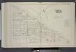
Vol. 4. Plate, A. [Map bound by Atlantic Ave., Flatbush Ave., St. Johns Place, Douglass St., Fourth Ave.; Including Pacific St., Dean St., Berg St., Wyckoff St., St. Marks Ave., Warren St., Prospect Pl., Baltic St., Park Pl., Butler St., Sterling Pl., Fi
from Detailed estate and old farm line atlas of the city of Brooklyn : complete in six volumes ... from official records, private plans, and actual surveys ... / by G.M. Hopkins, C.E.
Brooklyn, Vol. 1, Double Page Plate No. 25; Part of Ward 22, Section 4; [Map bounded by 8th St., 6th Ave., 13th St.; Including 8th Ave., 16th St., 4th Ave.]; Sub Plan; [Map bounded by 8th Ave., 13th St.; Including 14th St., Prospect Park
from Wards 1, 2, 3, 4, 5, 6, 8, 9, 10, 12 & 22.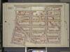
Brooklyn, Vol. 1, Double Page Plate No. 16; Part of Ward 9, Section 4; [Map bounded by Atlantic Ave., Underhill Ave., Sterling PL., St. John PL.; Including Flatbush Ave., 7th Ave, 6th Ave.]
from Wards 1, 2, 3, 4, 5, 6, 8, 9, 10, 12 & 22.
Brooklyn, V. 6, Double Page Plate No. 149 [Map bounded by Prospect Place, Carlton Ave., Atlantic Ave., Underhill Ave.]
From Atlas 80. Vol. 6, 1888.
Brooklyn
From Vol. 6
Brooklyn, Section 10; [Including Ward 22]
from Farm line map of the city of Brooklyn, from official records and surveys; comp. and drawn by Henry Fulton.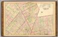
Sec. 5. Brooklyn map.
1 : 6000 Fulton, Henry; J.B. Beers & Co.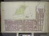
Brooklyn, Vol. 1, Double Page Plate No. 13; Part of Ward 22, Section 4; [Map bounded by Prospect Park West, 15th St., Coney Island Rd., 11th Ave.; Including Prospect Ave., 7th Ave., Carroll St]; Sub Plan [Map bounded by Ocean Ave., Gaton Ave., Coney I...
From Volume 1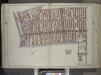
Brooklyn, Vol. 1, Double Page Plate No. 14; Part of Wards 9 & 22, Section 4; [Map bounded by 7th Ave., 3rd St., Gowanus Canal, Lateral Canal; Including 1st St., 4th Ave., Atlantic Ave., Carlton Ave., Flatbush Ave.] / by and under the direction of Hugo...
From Volume 1
Part of Wards 9, 22 & 29. Land Map Sections, No. 4 & 6, Volume 1, Brooklyn Borough, New York City.
from Atlas of the Brooklyn borough of the City of New York : originally Kings Co.; complete in three volumes ... based upon official maps and plans ... / by and under the supervision of Hugo Ullitz, C.E.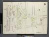
Brooklyn, V. 1, Double Page Plate No. 21 [Map bounded by Bond St., Gowanus Canal, Smith St., 2nd St.]
From Atlas 63. Vol. 1, 1886.
Sec. 10. Brooklyn map.
1 : 6000 Fulton, Henry; J.B. Beers & Co.
Plan for the drainage of that part of the city of Brooklyn which empties its water into Gowanus Creek & Bay / by Daniel Richards, Oct. 1848 ; Willard Day, city surveyor.
from Brooklyn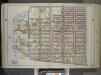
Brooklyn, Vol. 1, Double Page Plate No. 12; Part of Ward 22, Section 4; [Map bounded by 3rd St., 7th Ave., Prospect Ave., Hamilton Ave., Gowanus Canal] / by and under the direction of Hugo Ullitz.
From Volume 1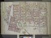
Brooklyn, Vol. 1, Double Page Plate No. 15; Part of Wards 9, 22 & 29, Section 4; [Map bounded by Atlantic Ave., Franklin Ave., Carroll St., Institute Park, Flatbush Ave., Plaza, Prospect Park Ave.; Including Carroll St., 7th Ave., Flatbush Ave., Carlt...
From Volume 1
Part of Ward 22. Land Map Section, No. 4, Volume 1, Brooklyn Borough, New York City.
from Atlas of the Brooklyn borough of the City of New York : originally Kings Co.; complete in three volumes ... based upon official maps and plans ... / by and under the supervision of Hugo Ullitz, C.E.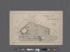
University Park, Brooklyn, N. Y., general improvement plan.
From Brooklyn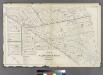
Plate 9: Part of Wards 3, 9, 10, 11, 20 & 22. City of Brooklyn.
from Atlas of the entire city of Brooklyn, complete in one volume. From actual surveys and official records by G. W. Bromley & Co.