Maps of Hudson County
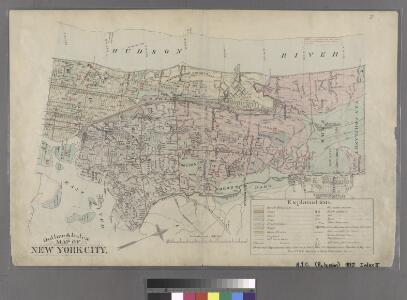
Robinson's Atlas of the city of New York : embracing all territory within its corporate limits from official records, private plans & actual surveys
from Atlas of the city of New York : embracing all territory within its corporate limits from official records, private plans & actual surveys / by and under the supervision of E. Robinson & R.H. Pidgeon, civil engineers.
Manhattan, V. 1, Plate No. 87 [Map bounded by Hudson River, Battery Pl., Broadway.]
From Atlas 109. Vol. 1, 1905.
Manhattan, V. 1, Plate No. 1 west half [Map bounded by Beaver St., Broad St., South St., State St.]
From Atlas 107. Vol. 1, 1894.
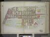
[1st Ward. Plate: A Map bounded by Bowling Green Row, Stone Street, Coenties Slip, South Street, Whitehall, State Street; Including Bridge Street, Pearl Street, Water Street, Front Street, Moore Street, Broad Street]
from Maps of the city of New York.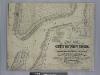
New map of that part of the city of New York south from 20th Street on the Hudson & 35th Street on the East River : showing the position of Greenwich, Washington and West Streets on the Hudson River, and Pearl, Water, Front, Cherry & Tompkins Sts. on the
from Manhattan
[Volume 2 Index Map]
from Maps of the city of New York.
New map of the part of New York City 20th St. on the Hudson and 35th St. on the East River
From Manhattan
Plan of the city of Brooklyn, L.I. / by William Perris.
from Brooklyn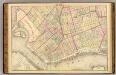
Sec. 2. Brooklyn map.
1 : 6000 Fulton, Henry; J.B. Beers & Co.
12C - N.Y. City (Aerial Set).
from Sectional aerial maps of the City of New York / [photographed and assembled under the direction of the chief engineer, July 1st, 1924].
Plan of the city of Brooklyn, L.I. / by William Perris.
from Brooklyn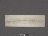
West Street [from Battery Park to Barrow Street.]
From Manhattan
Plan von der Stadt New-York.
from Manhattan
Sheet 5: Map encompassing Red Hook, Cobble Hill, Carroll Gardens and Gowanus Canal.
from Map of the city of Brooklyn : being the former cities of Brooklyn & Williamsburgh and the town of Bushwick, as consolidated January 1st, 1855 by an act of the legislature of the State of New York ... showing also a part of the City of New York.
Plan of the city of Brooklyn, L.I. / by William Perris.
from Brooklyn
16A - N.Y. City (Aerial Set).
from Sectional aerial maps of the City of New York / [photographed and assembled under the direction of the chief engineer, July 1st, 1924].
Key
From Atlas 107. Vol. 1, 1894.
Data for population from census of 1910, Borough of Manhattan
From Manhattan
Map of the city of New-York extending northward to Fiftieth St. / surveyed and drawn by John F. Harrison, C.E.
from Manhattan
To His Excellency Sr. Henry Moore, Bart., captain general and governour in chief, in & over the Province of New York & the territories depending thereon in America, chancellor & vice admiral of the same, this plan of the city of New York, is
from Manhattan
To His Excellency Sr. Henry Moore, Bart., captain general and governour in chief in & over the province of New York & the territories depending thereon in America, chancellor & vice admiral of the same, this plan of the city of New York is mo
from Charts and maps
Financial District map of New York City. Aero view of financial distrct above map.
From Manhattan
Sheet 3: [Bounded by Reade Street, Nassau Street, Pearl Street, Chatham Street, Oliver Street, (Pier Line) South Street, (Battery) State Street, Battery Place and West Street.]
from Plan of New York City, from the Battery to Spuyten Duyvil Creek. Showing every lot and building thereon; old farm lines, strreet numbers at the corners of blocks, railroads, steamboat landings, bulkhead and pier lines, etc. Based on the surveys made by Messrs. Randall & Blackwell, and on the special survey by J. F. Harrison.
A plan of the city of New York from an actual survey
1 : 3200 Lyne, James reproduced by Henry Dunreath Tyler
[Plate 1: Bounded by Liberty Street, Maiden Lane, South Street [East River, Piers 1-18], White Hall Street, State Street (Battery Park), Battery Place,and (Hudson River, Piers A, 1-14) West Street.]
from Atlas of the city of New York, Manhattan Island. From actual surveys and official plans / by George W. and Walter S. Bromley.
New York, the English colonial city, 1730 / [cartographic material]
From Early New York history, portrayed in five maps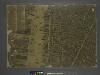
The city of New York / Will L. Taylor, chief draughtsman.
from Whole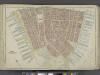
Manhattan, Double Page Plate No. 1 [Map bounded by Liberty St., Maiden Lane, East River, Hudson River]
From Atlas of the city of New York, Manhattan Island. From actual surveys and official plans
Ville de Manathe ou Nouvelle-Yorc.
from Manhattan