Maps of Jászapáti járás

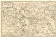
Jasz-Ladany.; Spezialkarte der osterreichisch-ungarischen Monarchie.
from Spezialkarte der osterreichisch-ungarischen Monarchie. Austro-Hungarian Monarchy. Militärgeographisches Institut.,
Jász-Nagykun-Szolnok vármegye térképe
1 : 500000 Szolnok (Maďarsko : oblast) Kogutowicz, Manó Magyar Földrajzi Intézet
Jász-Berény 149, uit: Special-Karte von Mittel-Europa / nach amtlichen Quellen bearbeitet von W. Liebenow
1 : 300000 titelvariant: W. Liebenow's Mittel-Europa; Annotatie: Titel boven de bladen: W. Liebenow's Mittel-Europa Johannes Wilhelm Liebenow 1822-1897 Frankfurt a. M. : Ludwig Ravenstein
Heves és Külsö-Szölnok törv. egyesült vármegyek
1 : 540000 Szolnok-oblast (Maďarsko) Litzner, Joannes Baptist
Mappa Comitatus Pesthiensis Methodo Astronomico-Geometrica, concinnata.
1 : 166600 Mollova mapová sbírka Mikoviny, Sámuel Nicolaï, Georg David Christoph
Szolnok.
from Spezialkarte der osterreichisch-ungarischen Monarchie.
Tisza-Roff.
from Spezialkarte der osterreichisch-ungarischen Monarchie.

C. Heves und Szólnok
Ungarn Komitat Heves

Generalkarte von Zentraleuropa

C. Pestensis
Ungarn Komitat Pest
Pesth-Solter, Csongráder, Szolnoker Comitat und das Ober Capitanat von Jazygien und Cumanien
1 : 280000 Budapešť-oblast (Maďarsko)
Szeged és Debrecen
1 : 750000 Debrecín (Maďarsko : oblast) M. Kir. Állami Térképészet
Nieder Ungern
Maďarsko Kipferling, Karl Joseph Benedict, Anton im Verlage des Kunst- und Industrie Comptoirs
Nieder Ungern
Maďarsko Kipferling, Karl Joseph Benedict, Anton im Verlage des Kunst- und Industrie Comptoirs
Vermehrte und Verbesserte Landkarten des Königreichs Ungarn :
1 : 500000 Mollova mapová sbírka Stier, Martin Böner, Johann-Alexander Endter, Martin
Die Donau, der Fürst aller Europaeischen Flüsse :
Mollova mapová sbírka Hoffmann, Johannes Hoffmann, Johann
Sheet IX: Karte Des Oesterreichischen Kaiserstaates.
1 : 576000 Scheda, Josef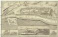
Plan de la fortresse de Bude vulgo Ofen
Budapešť (Maďarsko) Schmettau, Samuel von
A Tisavölgy vizszabályozasi átnézeti térképe

Szeged, Nagyvárad, Arad, Erlau, Szolnok
1 : 750000 Arad (Rumunsko) Fendl, J. K. u. k. Militärgeographisches Institut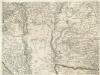
Augustissimo Romanor. Imperatori Iosepho I. Hungaria Regi Invictissimo Mappam Hanc Regni Hungariae
1 : 540000 Mollova mapová sbírka Müller, Johann Christoph
Szegedin, Grosswardein, Ó Arad, Erlau, Szolnok
1 : 750000 Arad (Rumunsko) K. k. militär-geographisches Institut
Comitate zwischen Pressburg u. Debreczin 1848, 1849
1 : 2775000 Ungarn Ungarn / Revolution <1848-1849>
Ober Ungern
Maďarsko Ossenbrug, J. von im Verlage des Kunst und Industrie Comptoir's
Ober Ungern
Maďarsko Ossenbrug, J. von im Verlage des Kunst und Industrie Comptoir's
Carte de la Roumanie et pays limitrophes. Szegedin
1 : 500000 France. Service géographique de l'armée [Paris] : Service géographique de l'armée
IX, uit: General-Karte des oesterreichischen Kaiserstaates mit einem grossen Theile der angrenzenden Länder / durch Josef Scheda ... bearb. und hrsg
1 : 576000 Annotatie geografische gegevens: Maatstokken: oesterreichische Meilen, geografische oder deutsche Meilen, preussische Meilen, türkische Berri, französische Lieues, russische Werste; Maatstok per blad: wiener Klafter, öster. Meilen; Blad XIX: statistische en taalkundige informatie; Blad XIX: legenda [Wien : K.K. Militärisch-Geografisches Institut]