Maps of Kunhegyesi járás

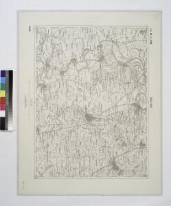
Tisza-Roff.
from Spezialkarte der osterreichisch-ungarischen Monarchie.
Tisza-Roff
1 : 75000 Komitat Jász-Nagykun-Szolnok
Kis-Ujszallas und Mezo-Tur.
from Spezialkarte der osterreichisch-ungarischen Monarchie.
Kis-Ujszállás
1 : 75000 Kisújszállás, Komitat Jász-Nagykun-Szolnok
Jász-Nagykun-Szolnok vármegye térképe
1 : 500000 Szolnok (Maďarsko : oblast) Kogutowicz, Manó Magyar Földrajzi Intézet
Heves és Külsö-Szölnok törv. egyesült vármegyek
1 : 540000 Szolnok-oblast (Maďarsko) Litzner, Joannes Baptist
C. Heves und Szólnok
Ungarn Komitat Heves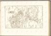

Generalkarte von Zentraleuropa

Debreczen 150, uit: Special-Karte von Mittel-Europa / nach amtlichen Quellen bearbeitet von W. Liebenow
1 : 300000 titelvariant: W. Liebenow's Mittel-Europa; Annotatie: Titel boven de bladen: W. Liebenow's Mittel-Europa Johannes Wilhelm Liebenow 1822-1897 Frankfurt a. M. : Ludwig Ravenstein
C. Békés
Ungarn Komitat Békés
Jász-Berény 149, uit: Special-Karte von Mittel-Europa / nach amtlichen Quellen bearbeitet von W. Liebenow
1 : 300000 titelvariant: W. Liebenow's Mittel-Europa; Annotatie: Titel boven de bladen: W. Liebenow's Mittel-Europa Johannes Wilhelm Liebenow 1822-1897 Frankfurt a. M. : Ludwig Ravenstein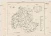
Comitat Heves
1 : 288000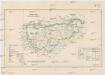
Comitat Gran
1 : 288000 Ostřihom (Maďarsko)
Gömörer Comitat
1 : 288000 Gemer (Slovensko : oblast)
Gömörer Comitat
1 : 290000 Revúca (Slovensko : oblast)
Gömörer Comitat
1 : 288000 Revúca-oblast (Slovensko)
Comitat Heves
1 : 290000
Besenyö und Tisza-Füred
1 : 75000 Tiszafüred, Umland Schrift und Gerippe v. Führer Miedl. Terrainschraffirung v. Joh. Le Gay Edl. v. Lierfels
Besenyo und Tisza-Fured.; Spezialkarte der osterreichisch-ungarischen Monarchie.
from Spezialkarte der osterreichisch-ungarischen Monarchie. Austro-Hungarian Monarchy. Militärgeographisches Institut.,
Püspök-Ladány
1 : 75000 Püspökladány, Hajdú-Bihar
Heves vármegye térképe
1 : 390000 Kogutowicz, Manó Magyar Földrajzi Intézet
Jasz-Ladany.; Spezialkarte der osterreichisch-ungarischen Monarchie.
from Spezialkarte der osterreichisch-ungarischen Monarchie. Austro-Hungarian Monarchy. Militärgeographisches Institut.,
Puspok-Ladany.; Spezialkarte der osterreichisch-ungarischen Monarchie.
from Spezialkarte der osterreichisch-ungarischen Monarchie. Austro-Hungarian Monarchy. Militärgeographisches Institut.,
N.-Bajom und Szeghalom (Ungarn).
from Spezialkarte der osterreichisch-ungarischen Monarchie.
Szolnok.
from Spezialkarte der osterreichisch-ungarischen Monarchie.
N.-Bajom
1 : 75000 Biharnagybajom, Hajdú-Bihar
Szolnok
1 : 75000 Szolnok, Szolnok (Region)
Pesth-Solter, Csongráder, Szolnoker Comitat und das Ober Capitanat von Jazygien und Cumanien
1 : 280000 Budapešť-oblast (Maďarsko)