Maps of Jász-Nagykun-Szolnok

Generalkarte von Zentraleuropa

Pesth-Solter, Csongráder, Szolnoker Comitat und das Ober Capitanat von Jazygien und Cumanien
1 : 280000 Budapešť-oblast (Maďarsko)
C. Heves und Szólnok
Ungarn Komitat Heves

C. Pestensis
Ungarn Komitat Pest
Jász-Nagykun-Szolnok vármegye térképe
1 : 500000 Szolnok (Maďarsko : oblast) Kogutowicz, Manó Magyar Földrajzi Intézet
Kecskemét 163, uit: Special-Karte von Mittel-Europa / nach amtlichen Quellen bearbeitet von W. Liebenow
1 : 300000 titelvariant: W. Liebenow's Mittel-Europa; Annotatie: Titel boven de bladen: W. Liebenow's Mittel-Europa Johannes Wilhelm Liebenow 1822-1897 Frankfurt a. M. : Ludwig Ravenstein
Heves és Külsö-Szölnok törv. egyesült vármegyek
1 : 540000 Szolnok-oblast (Maďarsko) Litzner, Joannes Baptist
Mappa Comitatus Pesthiensis Methodo Astronomico-Geometrica, concinnata.
1 : 166600 Mollova mapová sbírka Mikoviny, Sámuel Nicolaï, Georg David Christoph
Jász-Berény 149, uit: Special-Karte von Mittel-Europa / nach amtlichen Quellen bearbeitet von W. Liebenow
1 : 300000 titelvariant: W. Liebenow's Mittel-Europa; Annotatie: Titel boven de bladen: W. Liebenow's Mittel-Europa Johannes Wilhelm Liebenow 1822-1897 Frankfurt a. M. : Ludwig Ravenstein
Pesth-Piliser Comitat
1 : 280000 Budapešť-oblast (Maďarsko)
Tisza-Roff.
from Spezialkarte der osterreichisch-ungarischen Monarchie.
Czegled.
from Spezialkarte der osterreichisch-ungarischen Monarchie.
Kis-Ujszallas und Mezo-Tur.
from Spezialkarte der osterreichisch-ungarischen Monarchie.
Szarvas.
from Spezialkarte der osterreichisch-ungarischen Monarchie.
Tisza-Inoka.
from Spezialkarte der osterreichisch-ungarischen Monarchie.
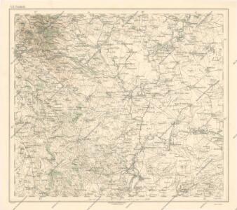
Szolnok.
from Spezialkarte der osterreichisch-ungarischen Monarchie.
Kiskunfelegyhaza und Szegvar.
from Spezialkarte der osterreichisch-ungarischen Monarchie.
Oroshaza.
from Spezialkarte der osterreichisch-ungarischen Monarchie.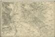
Bez titulu: Umgebungen von Pest

A Dunavölgy Átnézeti Térképe, Carte d ́ensemble del la Vallée du Danube XVI.

Soltvadkert
1 : 75000 Soltvadkert, Bács-Kiskun
Kis-Ujszállás
1 : 75000 Kisújszállás, Komitat Jász-Nagykun-Szolnok
Orosháza
1 : 75000 Orosháza, Orosháza (Region)
Cegléd
1 : 75000 Cegléd, Cegléd (Region)
Kiskunfélegyháza
1 : 75000 Kiskunfélegyháza, Bács-Kiskun
Szarvas
1 : 75000 Szarvas
Tisza-Roff
1 : 75000 Komitat Jász-Nagykun-Szolnok