Maps of Vyzhnytsia

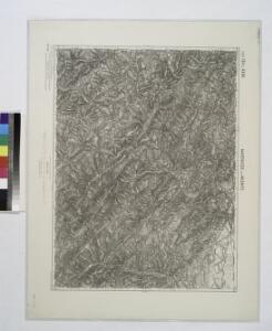
Marenicze und Wiznitz.; Spezialkarte der osterreichisch-ungarischen Monarchie.
from Spezialkarte der osterreichisch-ungarischen Monarchie. Austro-Hungarian Monarchy. Militärgeographisches Institut.,
Marenicze und Wiznitz
1 : 75000 Ukrajina Stotz, A. K. u. k. Militärgeographisches Institut

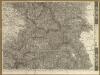
Kuty (Galizien).
from Spezialkarte der osterreichisch-ungarischen Monarchie.
Szipot-Kamerale (Bukowina).
from Spezialkarte der osterreichisch-ungarischen Monarchie.
Bukowina oder oestreich'scher Antheil der Moldau
1 : 580000 Bukovina (Rumunsko a Ukrajina) Küstel, Aloys J. Mare, Carl Gleditsch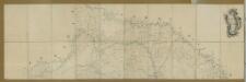
Carte de la Moldavie
1 : 330000 Moldawien, Bessarabien
Neue Generalkarte des Österr.-ungar.-russischen Kriegsschauplatzes

[Bukowina, Galizien]
1 Karte : Kupferdruck ; 18 x 13 cm [Trattner]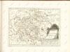

Ober Ungern
Rumunsko severní im Verlage des Kunst und Industrie Comptoirs
Ober Ungern
Rumunsko severní Ossenbrug, J. von Müller, Franz im Verlage des Kunst und Industrie Comptoirs
Vermehrte und Verbesserte Landkarten des Königreichs Ungarn :
1 : 500000 Mollova mapová sbírka Stier, Martin Böner, Johann-Alexander Endter, Martin
Carte de la Roumanie et pays limitrophes. Lemberg
1 : 500000 France. Service géographique de l'armée [Paris] : Service géographique de l'armée
Augustissimo Romanor. Imperatori Iosepho I. Hungaria Regi Invictissimo Mappam Hanc Regni Hungariae
1 : 540000 Mollova mapová sbírka Müller, Johann Christoph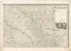
Mappa generalis regni Hungariae partiumque adnexarum Croatiae, Slavoniae...

Galizien, Östlicher Theil und Bukowina
1 : 700000 Bukovina (Rumunsko a Ukrajina) Karl Fr. Pfau
Bez titulu: Šest listů speciálních map Ukrajiny

Strassen- und Eisenbahnkarte des oesterreichischen Kaiserthumes
1 : 864000 Blatt 8 Schaller, G. K.K. Militärisch-Geografisches Institut, Karten-Evidenthaltungs-Abteilung
Sheet X: Karte Des Oesterreichischen Kaiserstaates.
1 : 576000 Scheda, Josef
X, uit: General-Karte des oesterreichischen Kaiserstaates mit einem grossen Theile der angrenzenden Länder / durch Josef Scheda ... bearb. und hrsg
1 : 576000 Annotatie geografische gegevens: Maatstokken: oesterreichische Meilen, geografische oder deutsche Meilen, preussische Meilen, türkische Berri, französische Lieues, russische Werste; Maatstok per blad: wiener Klafter, öster. Meilen; Blad XIX: statistische en taalkundige informatie; Blad XIX: legenda [Wien : K.K. Militärisch-Geografisches Institut]
Letecká mapa Evropy

Übersichtskarte von Mittel - Europa
Ungarn: Comitate: Beregh, Marmarozs, Ugocsa, Közep Szolnok, Kraszna, District Kövár. Siebenbürgen: Innerer Szolnok, Doboka, Clausenburg, Torda, Aranyoser Stuhl, Marozser Stuhl, Udvarhlyer Stuhl, Csiker Stuhl, und Bistriczer District
Ungarn Verkehrsweg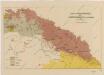
Sbírka map a diagramů použitých na mírových konferencích v Paříži v letech 1919 - 1920

G. Freytags Detailkarte von Nord-Rumänien (Moldau) und der Bukowina
1 : 400000 Bukovina (Rumunsko a Ukrajina) G. Freytag & Berndt
Principauté de Transilvanie Devisée en Cinq Nations Subdivisée en Quartiers et Comtez
1 : 760000 Mollova mapová sbírka Fer, Nicolas de Loon, Herman van Danet, Guillaume
Übrige Länder der ehemaligen Österreich-Ung. Monarchie
1 : 900000 Bukovina (Rumunsko a Ukrajina) Koch, Wilhelm Opitz, Carl Arnd
Principatus Transilvaniae in suas quasque Nationes earumque Sedes et Regiones cum finitimis vicinorum Statuum Provinciis accurate divisus
1 : 690000 Mollova mapová sbírka Homann, Johann Baptist Homann, Johann Baptista