Maps of Putyla Raion

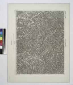
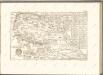
Szipot-Kamerale (Bukowina).
from Spezialkarte der osterreichisch-ungarischen Monarchie.
Szipot-Kamerale
1 : 75000 Oblast Tscherniwzi Geripp: Assistent Höller. Terrain: Leut. Scheyer u. Feuerwerker Pollek
Lambert-Cholesky sheet 3781 (Şipotele Sucevei)
1 : 20000 Romanian military topographic map sheet under Lambert-Cholensky projection Institutul Geografic Militar geo-spatial.org Institutul Geografic Militar
Lambert-Cholesky sheet 3780 (Izvor)
1 : 20000 Romanian military topographic map sheet under Lambert-Cholensky projection Institutul Geografic Militar geo-spatial.org Institutul Geografic Militar
Lambert-Cholesky sheet 3680 (Vrf. Tomnaticul)
1 : 20000 Romanian military topographic map sheet under Lambert-Cholensky projection Institutul Geografic Militar geo-spatial.org Institutul Geografic Militar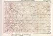
Lambert-Cholesky sheet 3880 (Muntele Vesnarca)
1 : 20000 Romanian military topographic map sheet under Lambert-Cholensky projection Serviciul Geografic al Armatei geo-spatial.org Serviciul Geografic al Armatei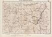
Lambert-Cholesky sheet 3881 (Ehreste)
1 : 20000 Romanian military topographic map sheet under Lambert-Cholensky projection Serviciul Geografic al Armatei geo-spatial.org Serviciul Geografic al Armatei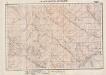
Lambert-Cholesky sheet 3882 (Brodina)
1 : 20000 Romanian military topographic map sheet under Lambert-Cholensky projection Serviciul Geografic al Armatei geo-spatial.org Serviciul Geografic al Armatei
Kirlibaba.; Spezialkarte der osterreichisch-ungarischen Monarchie.
from Spezialkarte der osterreichisch-ungarischen Monarchie. Austro-Hungarian Monarchy. Militärgeographisches Institut.,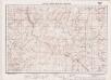
Lambert-Cholesky sheet 3582 (BURKUT)
1 : 20000 Romanian military topographic map sheet under Lambert-Cholensky projection Institutul Geografic Militar geo-spatial.org Institutul Geografic Militar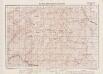
Lambert-Cholesky sheet 3581 (Vrf. Suligul)
1 : 20000 Romanian military topographic map sheet under Lambert-Cholensky projection Institutul Geografic Militar geo-spatial.org Institutul Geografic Militar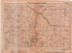
Lambert-Cholesky sheet 3580 (VRF. TOROIAGA)
1 : 20000 Romanian military topographic map sheet under Lambert-Cholensky projection Institutul Geografic Militar geo-spatial.org Institutul Geografic Militar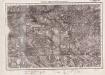
Lambert-Cholesky sheet 3679 (Vf. Zîmbroslavul)
1 : 20000 Romanian military topographic map sheet under Lambert-Cholensky projection Institutul Geografic Militar geo-spatial.org Institutul Geografic Militar
Lambert-Cholesky sheet 3779 (Moldova Suliţa)
1 : 20000 Romanian military topographic map sheet under Lambert-Cholensky projection Neprecizat geo-spatial.org Neprecizat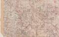
Lambert-Cholesky sheet 3879 (Breaza)
1 : 20000 Romanian military topographic map sheet under Lambert-Cholensky projection Neprecizat geo-spatial.org Neprecizat
Bukowina oder oestreich'scher Antheil der Moldau
1 : 580000 Bukovina (Rumunsko a Ukrajina) Küstel, Aloys J. Mare, Carl Gleditsch


Generalkarte von Zentraleuropa

Marenicze und Wiznitz.; Spezialkarte der osterreichisch-ungarischen Monarchie.
from Spezialkarte der osterreichisch-ungarischen Monarchie. Austro-Hungarian Monarchy. Militärgeographisches Institut.,
Ruszpolyana.; Spezialkarte der osterreichisch-ungarischen Monarchie.
from Spezialkarte der osterreichisch-ungarischen Monarchie. Austro-Hungarian Monarchy. Militärgeographisches Institut.,
Ruszpolyána
1 : 75000 Maramureş (Judeţ) Geripp: Assistent Pflügl. Terrain: Oberlt. Blaschke
Marenicze und Wiznitz
1 : 75000 Ukrajina Stotz, A. K. u. k. Militärgeographisches Institut
Ober Wikow.; Spezialkarte der osterreichisch-ungarischen Monarchie.
from Spezialkarte der osterreichisch-ungarischen Monarchie. Austro-Hungarian Monarchy. Militärgeographisches Institut.,
Felso-Visso.
from Spezialkarte der osterreichisch-ungarischen Monarchie.
III. vojenské mapování 4873
1 : 75000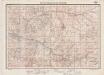
Lambert-Cholesky sheet 3579 (Borşa)
1 : 20000 Romanian military topographic map sheet under Lambert-Cholensky projection Institutul Geografic Militar geo-spatial.org Institutul Geografic Militar
[Bukowina, Galizien]
1 Karte : Kupferdruck ; 18 x 13 cm [Trattner]