Maps of Obříství

Schema des Moldau - Flusses von Prag bis Melnik

Verbindungs-Dreiecke der Grundlinie zwischen dem Lorenz- und Georgenberge mit der trigonometrischen Vermessung der Gegend um Neuschloss
Petřín (Praha, Česko)
Hydrografische Uibersichtskarte der Flüsse, Bäche und sonstigen Gewässer im Königreiche Boehmen


Plan der Gegend zwischen Kletzan und Weltrus
1 : 47500 Klecany (Česko) Schwihlik, F.
Plan der Gegend zwischen Kletzan und Weltrus
1 : 48000 Klecany (Česko) Adam
Prag's Umgebungen
Praha-oblast (Česko) Scheiner, Josef Kettner, C. J.G. Calve'sche Buchhandlung
Specielle Telegrafen und Eisenbahn Karte von Böhmen

Okolí Mělníka a Kralup n. V
1 : 25000 Kralupy nad Vltavou-oblast (Česko) Nešvera, P. Plesinger, Václav P. Nešvera a V. Plesinger
Prag und seine Umgebungen, nach den besten Hülfsmitteln dargestellt
1 : 42000 C. Kettner sculp. Prag : J. G. Calve'sche Buchhandlung
Situations - Plan der westlichen Gegend von Prag ...

Prag und seine Umgebungen
Praha (Česko) Bittner, Joseph Kettner, C. J. G. Calvesche Buchhandlung
Blocus de Prague
1 : 106600 Praha (Česko) Therbu Coentgen, Heinrich Hugo
Hlavní město Praha
1 : 55000 Praha (Česko)
Orientační plán hlavního města Prahy s okolím

Okolí města Prahy na hodinu cesty
Praha-oblast (Česko) K. Hübner
Nový, úředně schválený plán Velké Prahy
1 : 25000
Zu Bildner des Heeres Beilage 9
1 : 63000 Praha-oblast (Česko) K.k. Schulbücher-Verschleiss-Administration
Orientační plán Prahy a obcí sousedních přehledka

Orientační plán hlavního města Prahy
1 : 14000
Výškopisný plán hlavního města Prahy s okolím
1 : 20000 Praha (Česko) obec Pražská

Uliční mapa hlavního města Prahy

Praha : názorné plány a rejstřík

Plán sběrného okruhu a dopravních spojů pro motorová vozidla

Přehledná mapa Velké Prahy : [s průvodcem a popisem všech obcí v ní zahrnutých] : [odpolední výlety po okolí pražském]
1 : 34725
Plán Velké Prahy
1 : 19000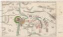
Accurate Vorstellung der zwischen den oesterreichischen und preussischen Armeen geschehenen Bataille bey Prag, den 6. May 1757
Praha (Česko)


