Maps of Sachsen
Norddeutsche Staaten

Circulus Saxoniae Superioris
1 : 480000 Mollova mapová sbírka Valk, Gerhard Valck, Gerard

Saxoniae, Misniae, Thvringiae, nova exactissimaq[ue] descriptio
1 Karte : Kupferdruck ; 31 x 47 cm Ortelius s.n.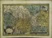
Saxoniae, Misniae, Thvringiae, nova exactissimaq[ue] descriptio
1 Karte : Kupferdruck ; 32 x 48 cm Ortelius s.n.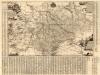
Neue Chur Saechsische Post Carte
1 : 330000 Mollova mapová sbírka Zürner, Adam Friedrich Bodenehr, Moritz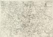
Saxonia Svperiore
1 : 800000 Mollova mapová sbírka Cosmerovius, Matthäus Cosmerovius, Matthäus
Saxoniae superioris Lvsatiae Misniaeqve descriptio
1 : 785000 Lužice (Německo) Mercator, Gerhard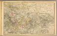
Thuringen u. Sachsen.
1 : 600000 Gutbier, Ludwig von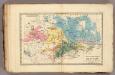
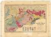
Saxe mineralogique.
1 : 1050000 Vincent
Dislokation der preuss. Armee in Sachsen und der gegenüber stehenden österreichischen und Reichs Armee in den Winterquartieren 1760/1

Misniae et Lvsatiae tabvla
1 Karte : Kupferdruck ; 28 x 20 cm Scultetus; Ortelius s.n.
Misniae et Lvsatiae tabvla
1 Karte : Kupferdruck ; 28 x 20 cm Scultetus; Ortelius s.n.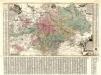
Aller Neueste Chur Saechsische Post Charte
1 : 340000 Mollova mapová sbírka Zürner, Adam Friedrich Lotter, Tobias Conrad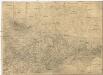
Oro- Hydro-Graphische General Charte vom Königreiche Sachsen und den angrenzenden Ländern
1 : 460000 Sasko (Německo) R. v. L. Bach, Joseph in der Rittnerschen Kunsthandlung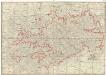
Post-Charte des Königreich Sachsen und der angränzenden Ländern
1 : 430000 Sasko (Německo) Güssefeld, Franz L. Geographisches Institut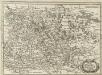
Ober Sachsen, Laussnitz und Meissen
1 : 1200000 Mollova mapová sbírka Merian, Matthaeus Merian, Matthäus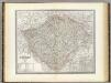
Bohmen.
1 : 675000 Weiland, C. F. (Carl Ferdinand), d. 1847
Saxoniae superioris
1 : 500000 Sasko (Německo) Lotter, Tobias Conrad T.C. Lotter
Saxoniae superioris
1 : 500000 Sasko (Německo) Lotter, Tobias Conrad T. C. Lotter

[Sasko]
Sasko (Německo) Jacob, Johann Gotthelff
Mapa války 1778-1779
1 : 1600000
Circulus Saxoniae Superioris
1 : 590000 Mollova mapová sbírka Homann, Johann Baptist Homann, Johann Baptista
Saxoniæ superioris circulus
1 Karte : Kupferdruck ; 48 x 56 cm Seutter Matthäus Seutter
CIRCULI SAXONIAE SUPERIORI[S]
1 : 620000 Anhaltsko (Německo) Wit, Frederick de F. de Wit
Circuli Saxoniae superiori[s] pars meridionalis
1 : 620000 Anhaltsko (Německo) Danckerts, Justus per Iustinum Danckerts
Saxoniae superioris
1 : 500000 Sasko (Německo) Lotter, Tobias Conrad per Tob. Conradum Lotter
Marchionatus Misniae in qua sunt Territorium Misniense, Lipsiense, Voitlandiae, Osterlandiae, Ertzgeburgi et Dominium Naumburgense Mersoburgense. Episcopatus Hallensis
1 : 380000 Mollova mapová sbírka Danckerts, Justus Danckerts, Justus