Maps of Saxony


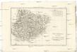
Misniae Et Lusatiae Tabula [Karte], in: Theatrum orbis terrarum, S. 230.
1 Karte aus Atlas Ortelius, Abraham Vrients, Jan Baptista
Misniae Et Lusatiae Tabula [Karte], in: Theatrum orbis terrarum, S. 138.
1 Karte aus Atlas Ortelius, Abraham
Sachsen, Thuringische Staaten.
1 : 870000 Andree, Richard
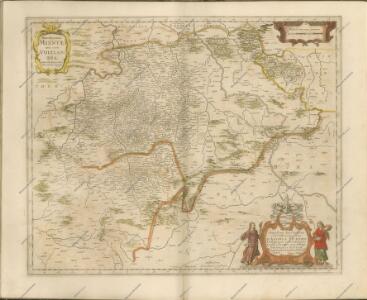
Saxoniae superioris
1 : 500000 Sasko (Německo) Lotter, Tobias Conrad per Tob. Conradum Lotter
Neue Karte des Kuhrfürstenthums [sic] Sachsen und sämtlicher incorporirter Lande, darinnen enthalten die VII. Kreise
Durynsko (Německo) Schenk, Pieter Petrus Schenk
Neue Karte des Kuhrfürstenthums Sachsen und sämtlicher incorporirter Lande, darinnen enthalten die VII. Kreise
1 : 520000 Durynsko (Německo) Schenk, Pieter Petrus Schenk
Saxoniae

Circuli Saxoniae Superioris Tabula ad usum serenissimi Burgundiae Ducis Parissis
1 : 740000 Mollova mapová sbírka Jaillot, Alexis-Hubert Ottens, Josua
Circuli Saxoniae Superioris Tabula ad usum serenissimi Burgundiae Ducis Parissis
1 : 740000 Mollova mapová sbírka Jaillot, Alexis-Hubert Jaillot, Alexis Hubert
Sachsen die Staaten in Thüringen und benachbartex Länder

Sachsen, Thueringen und benachbarte Länder
Hand-Atlas über alle Theile der Erde nach dem neuesten Zustande und über das Weltgebäude Stieler, Adolf bei Justus Perthes
Sachsen, Thüringen und Benachbarte Länder
Adolf Stieler's Handatlas über alle Theile der Erde und über das Weltgebäude Stieler, Adolf Justus Perthes
Sachsen, Thueringen und Benachbarte Länder
Hand-Atlas über alle Theile der Erde und über das Weltgebäude Stieler, Adolf Justus Perthes
Das Königreich Sachen
Neuester Schul-Atlas Walch, Johann im Verlag bei Joh. Walch
Sachsen, Thüringen und Benachbarte Länder
Handatlas über alle Theile der Erde und über das Weltgebäude Stieler, Adolf Justus Perthes
Sachsen, Thüringen und Benachbarte Laender
Stieler's Hand-Atlas Stieler, Adolf bei Justus Perthes
Misniae et Lvsatiae tabvla
1 Karte : Kupferdruck ; 28 x 20 cm Scultetus; Ortelius s.n.
Misniae et Lvsatiae tabvla
1 Karte : Kupferdruck ; 28 x 20 cm Scultetus; Ortelius s.n.
Circulus Saxoniae Superioris
1 : 590000 Mollova mapová sbírka Homann, Johann Baptist Homann, Johann Baptista
Sachsen, Thuringen und benachbarte Lander.
1 : 925000 Vogel, C.
Partie méridionale de cercle de la Haute Saxe
1 : 1740000 Sasko (Německo) Bonne, Rigobert André
Marchionatus Misniae una cum Voitlandia. [Karte], in: Novus atlas absolutissimus, Bd. 2, S. 69.
1 Karte aus Atlas Janssonius Offizin
Sachsen, Thüringen und Benachbarte Laender
Hand-Atlas über alle Theile der Erde nach dem neuesten Zustande und über das Weltgebäude Stieler, Adolf bei Justus Perthes
Circuli Supe. Saxoniae Pars Meridionalis sive Ducatus, Electoratus et Principatus Ducum Saxoniae
1 : 680000 Mollova mapová sbírka Zollmann, Friedrich Homann, Johann Baptista - dědici
Parte del Circolo dell Alta Sassonia
1 : 750000 Mollova mapová sbírka Cantelli, Giacomo De Rossi, Giovanni Giacomo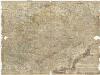
Neue und accurate Landkarte des Mittägig- Ober- Sächsischen R. Reichs- Creyß
1 : 700000 Bavorsko (Německo) Lidl, Johann Jakob Johann Jacob Lidl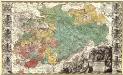
Dvcatvs Electoratus et Principatus Dvcvm Saxoniae pro ut illorum conditio hodierna est Geographice consignati.
1 : 680000 Mollova mapová sbírka Homann, Johann Baptist Homann, Johann Baptista - dědici