Maps of Smíchov

Orientační plán Prahy a obcí sousedních List 20.
1 : 5000
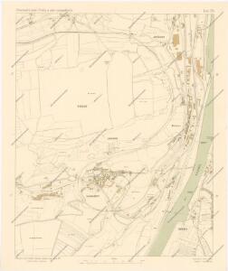
Orientační plán Prahy a obcí sousedních List 20.

Orientační plán hlavního města Prahy s okolím

Orientační plán hlavního města Prahy s okolím

Orientační plán hlavního města Prahy s okolím
1 : 5000
Radlitz (Radlic) - c6361-1-002 - Kaiserpflichtexemplar der Landkarten des stabilen Katasters
1 : 2880
Radlitz (Radlic) - c6361-1-001 - Kaiserpflichtexemplar der Landkarten des stabilen Katasters
1 : 2880
Stereofotogrammetrické zaměření... Vltavy, Otavy... pomocí Zeissova fototeodolitu

Hluboczep (Hluboczepy) - c1885-1-004 - Kaiserpflichtexemplar der Landkarten des stabilen Katasters
1 : 2880
Hluboczep (Hluboczepy) - c1885-1-001 - Kaiserpflichtexemplar der Landkarten des stabilen Katasters
1 : 2880
Hluboczep (Hluboczepy) - c1885-1-003 - Kaiserpflichtexemplar der Landkarten des stabilen Katasters
1 : 2880
Hluboczep (Hluboczepy) - c1885-1-002 - Kaiserpflichtexemplar der Landkarten des stabilen Katasters
1 : 2880
Ginonitz (Ginonic) - c2920-1-004 - Kaiserpflichtexemplar der Landkarten des stabilen Katasters
1 : 2880
Ginonitz (Ginonic) - c2920-1-002 - Kaiserpflichtexemplar der Landkarten des stabilen Katasters
1 : 2880
Ginonitz (Ginonic) - c2920-1-003 - Kaiserpflichtexemplar der Landkarten des stabilen Katasters
1 : 2880
Ginonitz (Ginonic) - c2920-1-005 - Kaiserpflichtexemplar der Landkarten des stabilen Katasters
1 : 2880
Ginonitz (Ginonic) - c2920-1-001 - Kaiserpflichtexemplar der Landkarten des stabilen Katasters
1 : 2880
Auto-Praha : automobilní plán Velké Prahy a příručka pro automobilisty
1 : 50000
Environs de Hlubočep
1 : 6150 Hlubočepy (Praha, Česko) Barrande, Joachim
Okolí nádraží c.k. české výsadní dráhy západní
Smíchov (Praha, Česko) Nehasil, F. Bembé
Plan des südlichen Moldauthal ́s bei Prag

Orientační plán hlavního města Prahy

Grundtriss der Prager Stätte
Praha, hlavní město ČSR : Fastrův obrázkový plán a průvodce
1 : 10000
Potrubí a situace nové vodárny pražské (vyznačeno červeně)
1 : 14300 Praha (Česko)
Orientační plán sídel. hlav. města Prahy
1 : 12000 Libeň (Praha, Česko) M. Král
Bez titulu: Plán hlavního města Prahy

Environs de Hlubočep
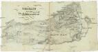
Terrain für das 2te Feldmanoeuvre
1 : 60000 Praha (Česko)