Maps of Pardubický

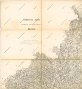
Operations-Karte des nördlichen-Kriegsschauplatern Mähren

G. Freytag – Autostrassenkarten: 20. Brünn
Mapa země moravské

General Karte der Markgrafschaft Mähren und des Herzogthums Schlesien

Mappa dioeceseos Reginaehradecensis
1 : 190000 Chrudim (Česko) Venuto, Jan Antonín Hay, Jan Leopold
Mappa dioceseos Reginaehradecensis in usum et commodum venerabilis cleridiocesani delineata
1 : 190000 Kraj Vysočina (Česko : 2000-) Venuto, Jan Antonín Hay, Jan Leopold
Mappa dioeceseos Reginaehradecensis
1 : 190000 Chrudim (Česko) Venuto, Jan Antonín Hay, Jan Leopold
Mappa dioeceseos Reginaehradecensis
1 : 190000 Chrudim (Česko) Venuto, Jan Antonín Hay, Jan Leopold
Mappa dioeceseos Reginaehradecensis
1 : 190000 Chrudim (Česko) Venuto, Jan Antonín Hay, Jan Leopold
Církevní mapa biskupství Králové-Hradeckého
Prozkoumání Čech, sekce VI.
Neubertova generální automapa Republiky československé
1 : 200000 Kolín (Česko : oblast) Soukup, Jan V. Neubert a synové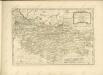

Östliches Böhmen

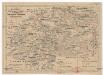
Moraviae, qvae olim Marcomannorvm sedes, corographia
1 : 450000 Mollova mapová sbírka Fabricius, Pavel Coppens van Diest, Gillis
Moraviae, qvae olim Marcomannorvm sedes, corographia
1 : 450000 Mollova mapová sbírka Fabricius, Pavel Coppens van Diest, Gillis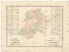
R. 1889 Českým sněmem navržený obvod obchodní komory pro východní Čechy
Čechy východní (Česko) Milbauer, Emanuel Vlastimil
Carte chorographique de la Boheme...

Charte vom Chrudimer Kreise des Königreiches Böheim

Carte Topographique d'Allemagne.
1 : 220000 Mollova mapová sbírka Coentgen, Heinrich Hugo Jäger, Johann Wilhelm Abraham
Special-Karte des Chrudimer Kreis, resp. politischen Verwaltungsbezirkes in Böhmen
1 : 213000 Chrudim-oblast (Česko) Schmidt, Eduard Wend. Morauer
Special-Karte des Chrudimer Kreis - resp. politischen Verwaltungsbezirkes in Böhmen
1 : 213000 Chrudim-oblast (Česko) Schmidt, Eduard Wend. Morauer
Special-Karte des Chrudimer Kreis, resp. politischen Verwaltungsbezirkes in Böhmen
1 : 213000 Chrudim-oblast (Česko) Schmidt, Eduard Wend. Morauer
Soustavná elektrisace území Východočeského elektrárenského svazu, spol. s r. o. (VČES) v Pardubicích
1 : 200000 Čechy východní (Česko) Wagner, Jan Eduard Štumper, Karel Vojenský zeměpisný ústav
Východní Čechy
1 : 22000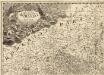
Tabula Generalis Marchionatus Moraviae in sex circulos divisae
1 : 183000 Mollova mapová sbírka Müller, Johann Christoph Gastl, Jan Jiří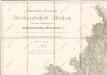
General-Karte der Markgrafschaft Maehrem...
Charte ehemaliger Burgen & Vesten im Časlauer & Chrudimer Kreise Böhmens
1 : 530000 Čáslav-oblast (Kutná Hora, Česko) Heber, Franz Alexander Türke, V. C.W. Medau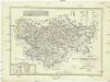
Karte des Pardubitzer Kreises im östereichischen Kronlande Böhmen
1 : 300000 Kraj Vysočina (Česko : 2000-) Obentraut, Maximilian Friedrich Kretzschmar