Maps of Northeast

Obvod Obchodní a živnostenské komory v Praze
1 : 500000 Čechy střední (Česko) Pospíšil, E. Ant. Vitek
Neubertova generální automapa Republiky československé
1 : 200000 Kolín (Česko : oblast) Soukup, Jan V. Neubert a synové
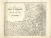
Partie de la Boheme du nord est
Chrudim-oblast (Česko) Kindermann, Joseph Karl Benedict, Ant. im Verlage des Kunst- und Industrie Comptoirs
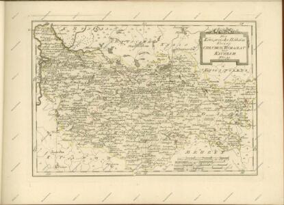
Nordöstlicher Theil von Boehmen enthaltend den Bunzlauer, Bidschower, Königgrätzer, Chrudimer, Czaslauer und Kaurzimer Kreis
1 : 540000 Chrudim-oblast (Česko) Kindermann, Joseph Karl Benedict, Ant. Kunst und Industrie Comptoir
Industrie-Karte des Bezirkes der Handels- und Gewerbekammer in Prag
1 : 370000 Praha (Česko : oblast)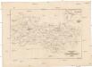
Industrie-Karte des Bezirkes der Handels- und Gewerbekammer in Prag
1 : 370000 Praha (Česko)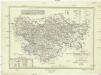
Karte des Pardubitzer Kreises im östereichischen Kronlande Böhmen
1 : 300000 Kraj Vysočina (Česko : 2000-) Obentraut, Maximilian Friedrich Kretzschmar
Karte des Pardubitzer Kreises im oestereichischen Kronlande Boehmen
1 : 290000 Pardubice-oblast (Česko) Kretzschmar, Friedrich Friedrich Kretzschmar
Mappa dioeceseos Reginaehradecensis
1 : 190000 Chrudim (Česko) Venuto, Jan Antonín Hay, Jan Leopold
Mappa dioceseos Reginaehradecensis in usum et commodum venerabilis cleridiocesani delineata
1 : 190000 Kraj Vysočina (Česko : 2000-) Venuto, Jan Antonín Hay, Jan Leopold
Mappa dioeceseos Reginaehradecensis
1 : 190000 Chrudim (Česko) Venuto, Jan Antonín Hay, Jan Leopold
Mappa dioeceseos Reginaehradecensis
1 : 190000 Chrudim (Česko) Venuto, Jan Antonín Hay, Jan Leopold
Mappa dioeceseos Reginaehradecensis
1 : 190000 Chrudim (Česko) Venuto, Jan Antonín Hay, Jan Leopold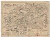
Charte ehemaliger Burgen & Vesten im Časlauer & Chrudimer Kreise Böhmens
1 : 530000 Čáslav-oblast (Kutná Hora, Česko) Heber, Franz Alexander Türke, V. C.W. Medau
Církevní mapa biskupství Králové-Hradeckého

Special-Karte des Pardubitzer Kreises
1 : 288000 Pardubický kraj (Česko) David, Johann Nep. Verlag des lithographischen Instituts von Josef Geljnek
Prozkoumání Čech, sekce VI.

Operations-Karte des nördlichen-Kriegsschauplatern Mähren
Mapa země moravské

General Karte der Markgrafschaft Mähren und des Herzogthums Schlesien

Königgrätz 104, uit: Special-Karte von Mittel-Europa / nach amtlichen Quellen bearbeitet von W. Liebenow
1 : 300000 titelvariant: W. Liebenow's Mittel-Europa; Annotatie: Titel boven de bladen: W. Liebenow's Mittel-Europa Johannes Wilhelm Liebenow 1822-1897 Frankfurt a. M. : Ludwig Ravenstein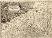
Tabula Generalis Marchionatus Moraviae in sex circulos divisae
1 : 183000 Mollova mapová sbírka Müller, Johann Christoph Gastl, Jan Jiří
Kaiser Ferdinand's Nordbahn
Olomouc (Česko) Rohrmann, P. P. Rohrmann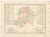
R. 1889 Českým sněmem navržený obvod obchodní komory pro východní Čechy
Čechy východní (Česko) Milbauer, Emanuel Vlastimil
Charte vom Chrudimer Kreise des Königreiches Böheim

Special-Karte des Časlauer Kreis, resp. politischen Verwaltungs Bezirkes im Königreiche Böhmen
1 : 230000 Čáslav-oblast (Kutná Hora, Česko) Schmidt, Eduard Wend. Morauer
Special-Karte des Časlauer Kreis, resp. politischen Verwaltungs Bezirkes im Königreiche Böhmen
1 : 230000 Čáslav-oblast (Kutná Hora, Česko) Schmidt, Eduard Wend. Morauer
Special-Karte des Časlauer Kreis, resp. politischen Verwaltungs Bezirkes im Königreiche Böhmen
1 : 230000 Čáslav-oblast (Kutná Hora, Česko) Schmidt, Eduard Wend. Morauer