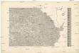
Maps of Pardubický

Carte chorographique de la Boheme...
Mapa země moravské

General Karte der Markgrafschaft Mähren und des Herzogthums Schlesien

Soustavná elektrisace území Východočeského elektrárenského svazu, spol. s r. o. (VČES) v Pardubicích
1 : 200000 Čechy východní (Česko) Wagner, Jan Eduard Štumper, Karel Vojenský zeměpisný ústav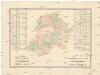
R. 1889 Českým sněmem navržený obvod obchodní komory pro východní Čechy
Čechy východní (Česko) Milbauer, Emanuel Vlastimil
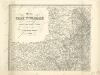
Charte vom Chrudimer Kreise des Königreiches Böheim

Strassen Charte des Chrudimer Kreises
1 : 48000 Chrudim (Česko : oblast) Werner, K.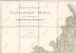
General-Karte der Markgrafschaft Maehrem...

Charte vom Chrudimer Kreise des Königreiches Böheim
1 : 260000 Chrudim-oblast (Česko) Kreibich, František Jakub Jindřich Pluth, Franz C. W. Enders
Charte vom Chrudimer Kreise des Königreiches Böheim
1 : 236000 Chrudim-oblast (Česko) Kreibich, František Jakub Jindřich Enders, C. W. C.W. Enders
Charte vom Chrudimer Kreise des Königreiches Böheim
1 : 236000 Chrudim-oblast (Česko) Kreibich, František Jakub Jindřich Enders, C. W. C.W. Enders
Charte vom Chrudimer Kreise des Königreiches Böheim
1 : 236000 Chrudim-oblast (Česko) Kreibich, František Jakub Jindřich Enders, C. W. C.W. Enders
Charte vom Chrudimer Kreise des Königreiches Böheim
1 : 236000 Chrudim-oblast (Česko) Kreibich, František Jakub Jindřich Enders, C. W. C.W. Enders
Charte vom Chrudimer Kreise des Königreiches Böheim
1 : 260000 Chrudim-oblast (Česko) Kreibich, František Jakub Jindřich Pluth, Franz C. W. Enders
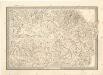
Special-Karte des Chrudimer Kreis, resp. politischen Verwaltungsbezirkes in Böhmen
1 : 213000 Chrudim-oblast (Česko) Schmidt, Eduard Wend. Morauer
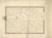
Special-Karte des Chrudimer Kreis - resp. politischen Verwaltungsbezirkes in Böhmen
1 : 213000 Chrudim-oblast (Česko) Schmidt, Eduard Wend. Morauer
Special-Karte des Chrudimer Kreis, resp. politischen Verwaltungsbezirkes in Böhmen
1 : 213000 Chrudim-oblast (Česko) Schmidt, Eduard Wend. Morauer
Prozkoumání Čech, sekce VI.
Prozkoumání Čech, sekce VI.

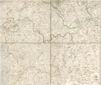
Östliches Böhmen

Kaiser Ferdinand's Nordbahn
Olomouc (Česko) Rohrmann, P. P. Rohrmann
Východní Čechy
1 : 22000
Special-Karte des Pardubitzer Kreises
1 : 288000 Pardubický kraj (Česko) David, Johann Nep. Verlag des lithographischen Instituts von Josef Geljnek
Chrudimer Kreis

okres Chrudim
1 : 200000
Chrudimer Kreis
Prozkoumání Čech, sekce VI.

Charte des Chrudimer Kreises im Koenigreiche Boehmen
Chrudim-oblast (Česko) Hollmann, Victor Josef Pluth, Franz Ad. Christoph & W. Kuhé
Kraj pardubický