Maps of Dobwalls and Trewidland

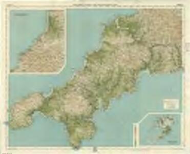
Cornwall, Sheet 37 - Bartholomew's "Half Inch to the Mile Maps" of England & Wales
1 : 126720 Topographic maps Bartholomew, John George John Bartholomew & Co
Sheets 1-2. (Cary's England, Wales, and Scotland).
1 : 360000 Cary, John, ca. 1754-1835
Truro and Falmouth - OS One-Inch Map
1 : 63360 Topographic maps Ordnance Survey Ordnance Survey
Lands End - OS One-Inch Map
1 : 63360 Topographic maps Ordnance Survey Ordnance Survey
Newquay and Padstow - OS One-Inch Map
1 : 63360 Topographic maps Ordnance Survey Ordnance Survey
Een gedeelte van het Kanaal van de rivier van Falmouth tot aen Engelands Eijnde
England Gerard van Keulen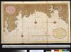
Een gedeelte van het Kanaal vant eijland Bun tot de R. van Vaalmouth
England Gerard van Keulen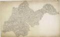
Helston, Cornwall
This drawing is attributed to Robert Dawson (1771-1860), a first-class Royal Military Draughtsman and Surveyor. He was also an influential teacher at the Tower of London Drawing Room, where he had been employed since the age of eighteen. The map is oriented unconventionally, with north to the left rather than at the top. Consequently, Lizard Head, the southernmost point of Great Britain, lies to the right of the plan. The boundaries of the area surveyed are coastal from Porthleven to Falmouth Bay, but at Lower Trenoweth they leave the coastline and follow the roads inland. The word 'flag' is written in several places (the tip of the Lizard, for example) to mark points between which Dawson took angular measurements to pinpoint topographical features. Similarly Signal Staff points are noted around the coast at Black Head and below Mullion Island. Helston was a tin-mining town. Copper and tin mines in the area are indicated by symbols. Dawson, Robert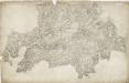
Grampound, Cornwall
1 : 31680 Military batteries are marked along the coastline in this drawing. The profusion of defensive castles in this area is testimony to the perceived vulnerability of coastal regions. Red blocks indicate individual structures within the complex of Pendennis Castle, built by Henry VIII after his divorce from Catherine of Aragon aroused the hostility of Catholic France and Spain. The nearby castle of St Mawes acted as a seaward deterrent, protecting the anchorage of Falmouth. Half Moon Battery is indicated, as are signal seats along the extreme edge of the coast. Budgen, Charles
Land's End, Cornwall
On this plan of a section of the English south coast, tin and copper mines ('wheals') are indicated by lines of dots arranged in blocks. To the left of Sancred, the ancient fort of Caer Bran is denoted by a circular marking, even though systematic recording of archaeological sites did not become obligatory until 1816. The drawing is considerably worn around the edges, rendering the cartographic detail almost illegible. Long Ships lighthouse is faintly discernible. Colour washes have faded and margins have been trimmed. Hewitt, John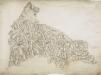
St. Columb Major, Cornwall
1 : 31680 .This drawing is orientated toward the south-east. On its reverse, obscured by backing material, is a triangulation diagram used to plot locations accurately. Tin and copper mines are marked, and a key to the symbols used to distinguish them is given at the bottom of the drawing. ."Harmony Cot" is marked as the birthplace of the portrait painter, John Opie (1761-1807). The inclusion of such information seems at odds with the Survey's military emphasis, but it does reflect the interests and training of the draughtsmen, many of whom were professional artists. To the north of St Columb Major lies the ancient monument known as the Nine Maidens, symbolised by a drawing of stones. A dot, annotated "point", appears in the bottom left hand corner of the map. This is probably the coastal station at Trevose Head, a base for the measurement of angles of elevation. Dawson, Robert
Padstow, Cornwall
This drawing shows three separate landmasses on the north coast of Cornwall. The area comprising Trevose Head and the estuary of the River Camel at Padstow is drawn at a scale of 2 inches to the mile, as is the inland region south of Tredinnick and Saint Breok Downs to Roche. The area from Hensbarrow Downs to Luxulyan and Saint Blazey is depicted at the larger scale of 3 inches to the mile. The drawing is attributed to Robert Dawson (1771-1860) who represented relief by shading in short disconnected lines drawn in the direction of the slopes - a technique known as hachuring. Dawson also estimated altitudes in pencil, depicting highpoints of almost 20 metres at Saint Breok Downs. Pencil intersections spread from the upper-left landmass, indicating lines between fixed points used for triangulation. Dirt marks remain where the map was formerly folded in four. Plans were not stored flat between deal boards until the1820s. Dawson, Robert
A coloured chart of Falmouth Haven and the river Fal up to Truro; drawn 1590-1600
This sixteenth century drawing shows the layout of Falmouth harbour in Cornwall. It must have been drawn after the completion of Pendennis and St Mawes Castles in the 1540’s as these are depicted, although in a fanciful manner bearing little resemblance to the real structures. These castles were part of a defensive chain built by Henry VIII after a peace treaty was signed by Francis I of France and Charles V, Holy Roman Emperor and King of Spain in 1538, making invasion of England probable. England and France were ancient enemies and the catholic Charles V, nephew of Catherine of Aragon, was angered by Henry VIII’s decision to divorce her. Henry’s dissolution of the monasteries provided him with enormous wealth with which he was able to commission surveys of the vulnerable coastline and build defence fortifications. This drawing was probably executed to provide a record of this vulnerable area of the coast for defensive purposes. It is possible that this drawing may date from 1598 – 1599 when the military engineer Paul Ivey was responsible for strengthening St Mawes and Pendennis following the 1597 scare that the Spanish might direct an armada towards Falmouth Haven. Pictorial depiction’s of castles, ships and sea monsters feature on this map which verges on the fanciful in its details, the naval battle in the top left is simply an embellishment. In the bottom left hand corner is a clover leaf pattern that is in fact an accurate ground plan of St Mawes Castle. A later annotator may have drawn this in an attempt to correct the picturesque inaccuracy of its depiction in this drawing.
Penzance (Hills) - OS One-Inch Revised New Series
1 : 63360 Topographic maps Ordnance Survey Ordnance Survey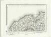
Penzance (Outline) - OS One-Inch Revised New Series
1 : 63360 Topographic maps Ordnance Survey Ordnance Survey
Land's End (Hills) - OS One-Inch Revised New Series
1 : 63360 Topographic maps Ordnance Survey Ordnance Survey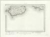
Land's End (Outline) - OS One-Inch Revised New Series
1 : 63360 Topographic maps Ordnance Survey Ordnance Survey
Newquay (Hills) - OS One-Inch Revised New Series
1 : 63360 Topographic maps Ordnance Survey Ordnance Survey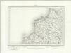
Newquay (Outline) - OS One-Inch Revised New Series
1 : 63360 Topographic maps Ordnance Survey Ordnance Survey
Falmouth (Hills) - OS One-Inch Revised New Series
1 : 63360 Topographic maps Ordnance Survey Ordnance Survey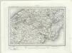
Falmouth (Outline) - OS One-Inch Revised New Series
1 : 63360 Topographic maps Ordnance Survey Ordnance Survey
Falmouth (Hills) - OS One-Inch Revised New Series
1 : 63360 Topographic maps Ordnance Survey Ordnance Survey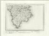
Falmouth (Outline) - OS One-Inch Revised New Series
1 : 63360 Topographic maps Ordnance Survey Ordnance Survey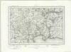
Bodmin (Outline) - OS One-Inch Revised New Series
1 : 63360 Topographic maps Ordnance Survey Ordnance Survey
Bodmin (Hills) - OS One-Inch Revised New Series
1 : 63360 Topographic maps Ordnance Survey Ordnance Survey
Mevagissey (Hills) - OS One-Inch Revised New Series
1 : 63360 Topographic maps Ordnance Survey Ordnance Survey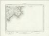
Mevagissey (Outline) - OS One-Inch Revised New Series
1 : 63360 Topographic maps Ordnance Survey Ordnance Survey
Redruth, Cornwall
The contouring technique used by Robert Dawson on this map precedes the introduction of obligatory contouring on Ordnance Survey maps in 1839-40. Short watercolour lines ('hachures'), drawn with a brush, follow the direction of slope and are paced to indicate the steepness of relief. Colour washes are steadily built up, giving realism to the depiction of hills, mountains and, in particular, the thickly wooded valleys descending from the moors and downs towards the sea. Tin and copper mining is evident around Redruth and Camborne. A triangulation diagram is inscribed on the reverse of the manuscript but is now obscured by backing material. Dawson, Robert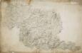
Bodmin, Cornwall
Bodmin Moor features on this drawing. The relative relief of the land is indicated by a combination of shading, brushwork interlining ('hachuring') and trigonometrical altitudes noted at the summit of inclines. Tin and copper mines are indicated by different symbols, and archaeological sites are shown by various yellow-tinted circular formations. The drawing spans three conjoined sheets. The 'Ordnance Office Copy' blind stamp can be seen in the top left corner. Dawson, Robert
Trevose Head (Hills) - OS One-Inch Revised New Series
1 : 63360 Topographic maps Ordnance Survey Ordnance Survey