Maps of Merseyside
Liverpool & Manchester, Sheet 8 - Bartholomew's "Half Inch to the Mile Maps" of England & Wales
1 : 126720 Topographic maps Bartholomew, John George John Bartholomew & Co
Cestria Comitatus Palatinus = The countye palatine of Chester
1 : 170000 [Amstelodami] : [apud Joannem Janssonium]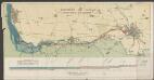
Manchester ship canal
1 : 62500 John Heywood
Liverpool - OS One-Inch Map
1 : 63360 Topographic maps Ordnance Survey Ordnance Survey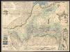
A mineralogical and geological map of the coalfield of Lancashire with parts of Yorkshire, Cheshire & Derbyshire
1 : 90000 Hall, Elias Elias Hall
Manchester - OS One-Inch Map
1 : 63360 Topographic maps Ordnance Survey Ordnance Survey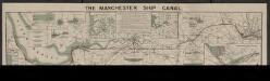
The Manchester ship canal
1 : 37000 Manchester : Engineer's office
Irischer Kanal
1 : 40000 Anglie Reichs-Marine-Amt
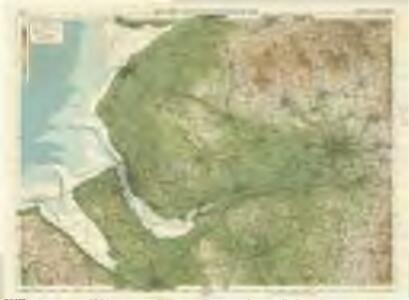
Formby (Hills) - OS One-Inch Revised New Series
1 : 63360 Topographic maps Ordnance Survey Ordnance Survey
Formby (Outline) - OS One-Inch Revised New Series
1 : 63360 Topographic maps Ordnance Survey Ordnance Survey
Manchester (Outline) - OS One-Inch Revised New Series
1 : 63360 Topographic maps Ordnance Survey Ordnance Survey
Manchester (Hills) - OS One-Inch Revised New Series
1 : 63360 Topographic maps Ordnance Survey Ordnance Survey
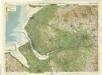
Liverpool (Outline) - OS One-Inch Revised New Series
1 : 63360 Topographic maps Ordnance Survey Ordnance Survey
Liverpool (Hills) - OS One-Inch Revised New Series
1 : 63360 Topographic maps Ordnance Survey Ordnance Survey
Stockport (Hills) - OS One-Inch Revised New Series
1 : 63360 Topographic maps Ordnance Survey Ordnance Survey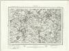
Stockport (Outline) - OS One-Inch Revised New Series
1 : 63360 Topographic maps Ordnance Survey Ordnance Survey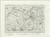
Wigan (Outline) - OS One-Inch Revised New Series
1 : 63360 Topographic maps Ordnance Survey Ordnance Survey
Wigan (Hills) - OS One-Inch Revised New Series
1 : 63360 Topographic maps Ordnance Survey Ordnance Survey
Runcorn (Hills) - OS One-Inch Revised New Series
1 : 63360 Topographic maps Ordnance Survey Ordnance Survey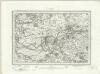
Runcorn (Outline) - OS One-Inch Revised New Series
1 : 63360 Topographic maps Ordnance Survey Ordnance Survey
Birkenhead
The formal title at the top left of this drawing states that Robert Dawson supervised the surveyor. One of the best surveyors and draughtsmen, Dawson was employed on the Ordnance Survey for over forty years, also working as an instructor. The scale of the drawing is noted and the area of the land is recorded as 64.0185 square miles. A triangulation diagram appears on the reverse of this drawing. This was an essential tool enabling draughtsmen to plot the exact location of topographical features. Hill sketching has not been included on this plan. Giles, John C.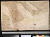
De rivier Dee of Chesterwater anders de rivier van Chester en Liverpoole int St. Joris Canaal beoosten t eijland Anglesij
England Gerard van Keulen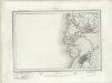
Southport (Outline) - OS One-Inch Revised New Series
1 : 63360 Topographic maps Ordnance Survey Ordnance Survey
Southport (Hills) - OS One-Inch Revised New Series
1 : 63360 Topographic maps Ordnance Survey Ordnance Survey
Rochdale (Hills) - OS One-Inch Revised New Series
1 : 63360 Topographic maps Ordnance Survey Ordnance Survey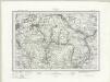
Rochdale (Outline) - OS One-Inch Revised New Series
1 : 63360 Topographic maps Ordnance Survey Ordnance Survey
Preston (Hills) - OS One-Inch Revised New Series
1 : 63360 Topographic maps Ordnance Survey Ordnance Survey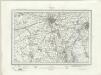
Preston (Outline) - OS One-Inch Revised New Series
1 : 63360 Topographic maps Ordnance Survey Ordnance Survey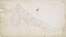
Flint
1 : 31680 A note in the bottom left corner of this drawing records the date it was received at the Drawing Office in the Tower of London, where final reduced copies of the plans were made. It is one of the few drawings to make reference to the Tower. A triangulation drawing appears on the reverse, along with an area calculation, referred to in its formal title. Major communication routes are highlighted in yellow, following standard military cartographic convention. Hughes, Herbert J.