Maps of Merseyside

Maps of Merseyside

$title$

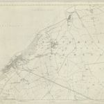
Liverpool - OS One-Inch Map
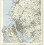
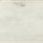
1 : 63360 Topographic maps Ordnance Survey Ordnance Survey
$title$

Irischer Kanal

1 : 40000 Anglie Reichs-Marine-Amt
$title$

De rivier Dee of Chesterwater anders de rivier van Chester en Liverpoole int St. Joris Canaal beoosten t eijland Anglesij

England Gerard van Keulen
$title$

The Manchester ship canal

1 : 37000 Manchester : Engineer's office
$title$

Birkenhead

The formal title at the top left of this drawing states that Robert Dawson supervised the surveyor. One of the best surveyors and draughtsmen, Dawson was employed on the Ordnance Survey for over forty years, also working as an instructor. The scale of the drawing is noted and the area of the land is recorded as 64.0185 square miles. A triangulation diagram appears on the reverse of this drawing. This was an essential tool enabling draughtsmen to plot the exact location of topographical features. Hill sketching has not been included on this plan. Giles, John C.
$title$

Runcorn (Hills) - OS One-Inch Revised New Series

1 : 63360 Topographic maps Ordnance Survey Ordnance Survey
$title$

Runcorn (Outline) - OS One-Inch Revised New Series

1 : 63360 Topographic maps Ordnance Survey Ordnance Survey
$title$

Wigan (Outline) - OS One-Inch Revised New Series

1 : 63360 Topographic maps Ordnance Survey Ordnance Survey
$title$

Wigan (Hills) - OS One-Inch Revised New Series

1 : 63360 Topographic maps Ordnance Survey Ordnance Survey
$title$

City of Liverpool : area 14,909 acres (exclusive of half of River Mersey)

1 : 15400 George Philip & Son George Philip & Son L[td] The London Geographical Institute
$title$

Liverpool (Outline) - OS One-Inch Revised New Series

1 : 63360 Topographic maps Ordnance Survey Ordnance Survey
$title$

Liverpool (Hills) - OS One-Inch Revised New Series

1 : 63360 Topographic maps Ordnance Survey Ordnance Survey
$title$

Formby (Hills) - OS One-Inch Revised New Series

1 : 63360 Topographic maps Ordnance Survey Ordnance Survey
$title$

Formby (Outline) - OS One-Inch Revised New Series

1 : 63360 Topographic maps Ordnance Survey Ordnance Survey
$title$

Hooton Hall

1 : 31680 .This drawing covers part of the Wirral, with the county border between Cheshire and Flintshire indicated by a red dotted line at the bottom left,,near the estuary of the River Dee. The map is formally titled at top left, and,features no hill sketches. Two-inch pencil squares superimposed over,the drawing,were,used for copying and reducing the map. Hughes, Herbert J.
$title$

Flint

1 : 31680 A note in the bottom left corner of this drawing records the date it was received at the Drawing Office in the Tower of London, where final reduced copies of the plans were made. It is one of the few drawings to make reference to the Tower. A triangulation drawing appears on the reverse, along with an area calculation, referred to in its formal title. Major communication routes are highlighted in yellow, following standard military cartographic convention. Hughes, Herbert J.
$title$

Map of the borough of Liverpool : with Parliamentary boundaries, ecclesiastical divisions and a part of the Cheshire coast

Hilliar, H engraved and published by H. Hilliar
$title$

Plan of the Mersey docks and harbour estate with part of the city of Liverpool

1 : 10750 s.n.
$title$

SD31 & Parts of SD21 - OS 1:25,000 Provisional Series Map

1 : 25000 Topographic maps Ordnance Survey Ordnance Survey
$title$

SD20 & Parts of SD31 - OS 1:25,000 Provisional Series Map

1 : 25000 Topographic maps Ordnance Survey Ordnance Survey
$title$

SJ28 - OS 1:25,000 Provisional Series Map

1 : 25000 Topographic maps Ordnance Survey Ordnance Survey
$title$

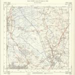
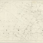
SD30 - OS 1:25,000 Provisional Series Map

1 : 25000 Topographic maps Ordnance Survey Ordnance Survey
$title$

SJ27 - OS 1:25,000 Provisional Series Map

1 : 25000 Topographic maps Ordnance Survey Ordnance Survey
$title$

SJ39 - OS 1:25,000 Provisional Series Map

1 : 25000 Topographic maps Ordnance Survey Ordnance Survey
$title$

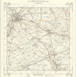
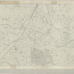
SD41 - OS 1:25,000 Provisional Series Map

1 : 25000 Topographic maps Ordnance Survey Ordnance Survey
$title$

SJ38 - OS 1:25,000 Provisional Series Map

1 : 25000 Topographic maps Ordnance Survey Ordnance Survey
$title$

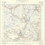
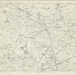
SD40 - OS 1:25,000 Provisional Series Map

1 : 25000 Topographic maps Ordnance Survey Ordnance Survey
$title$

SJ37 - OS 1:25,000 Provisional Series Map

1 : 25000 Topographic maps Ordnance Survey Ordnance Survey
$title$

SJ49 - OS 1:25,000 Provisional Series Map

1 : 25000 Topographic maps Ordnance Survey Ordnance Survey
$title$

SD51 - OS 1:25,000 Provisional Series Map

1 : 25000 Topographic maps Ordnance Survey Ordnance Survey
© MapTiler © OpenStreetMap contributors
How does it work?
These instructions will show you how to find historical maps online.
Getting started
Type the place name in the search box to find the exact location. You can further adjust the search by zooming in and out.
Zoom
Zoom in and out with the buttons or use your mouse or touchpad natively.
Exact Area tool
Click here and draw a rectangle over the map to precisely define the search area.
Set filters
Narrow your search with advanced settings, such as Years (from/to), Fulltext, Publisher, etc.
Results
See the results of your search on the right side. You can scroll down to find more maps of this location.
?

Download OldMapsOnline Mobile