Maps of Scottish Borders
Peebles-shire, Sheet 012.14 - 25 Inch Map
1 : 2500 Topographic maps Ordnance Survey Ordnance Survey
Peebles-shire, Sheet 012.14 - 25 Inch Map
1 : 2500 Topographic maps Ordnance Survey Ordnance Survey
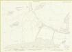
Peebles, Sheet XII.14 (Stobo) - OS 25 Inch map
1 : 2500 Topographic maps Ordnance Survey Ordnance Survey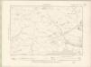
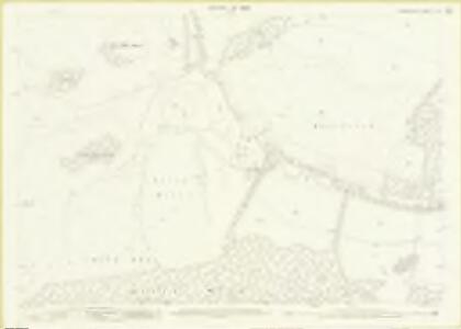
Peebles-shire Sheet XII.SW - OS 6 Inch map
1 : 10560 Topographic maps Ordnance Survey Ordnance Survey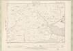
Peebles-shire Sheet XII.SW - OS 6 Inch map
1 : 10560 Topographic maps Ordnance Survey Ordnance Survey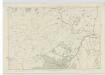
Peebles-shire, Sheet XII - OS 6 Inch map
1 : 10560 Topographic maps Ordnance Survey Ordnance Survey
NT13 - OS 1:25,000 Provisional Series Map
1 : 25000 Topographic maps Ordnance Survey Ordnance Survey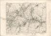
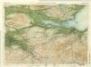
Peebles - OS One-Inch map
1 : 63360 Topographic maps Ordnance Survey Ordnance Survey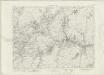
Peebles - OS One-Inch map
1 : 63360 Topographic maps Ordnance Survey Ordnance Survey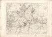
Peebles - OS One-Inch map
1 : 63360 Topographic maps Ordnance Survey Ordnance Survey
Peebles & Galashiels (80) - OS One-Inch map
1 : 63360 Topographic maps Ordnance Survey Ordnance Survey
Peebles & Galashiels (80) - OS One-Inch map
1 : 63360 Topographic maps Ordnance Survey Ordnance Survey
A new and correct map of the Shire of Peebles or Tweeddale / survey'd by Will. Edgar, 1741 ; R. Cooper sculp.
Edgar, William, fl. 1717-1746 Cooper, Richard, 1705-1764
The Shire of Peebles or Tweeddale.
Edgar, William, fl. 1717-1746
To the... Earl of March and Ruglen... this map of the County of Peebles or Tweedale is... inscribed by... Mostyn Jno. Armstrong
Armstrong, Mostyn, fl. 1769-1791
Peebles-Shire.
Thomson, John, 1777- ca. 1840 Johnson, William, fl. 1806-1840
Peebles-Shire.
1 : 78000 Thomson, John
Tvedia cum vicecomitatu Etterico Forestæ etiam Selkirkæ dictus
1 Karte : Kupferdruck ; 41 x 49 cm Blaeu; Pont Joan Blaeu
Tweddale, alias, The Shire of Peebles &c. / by H. Moll.
Moll, Herman, d. 1732
Selkirk - OS One-Inch Map
1 : 63360 Topographic maps Ordnance Survey Ordnance Survey
Edinburgh - OS One-Inch Map
1 : 63360 Topographic maps Ordnance Survey Ordnance Survey
Edinburgh - Bartholomew's 'Survey Atlas of Scotland'
1 : 126720 Topographic maps John Bartholomew & Son, Ltd John Bartholomew & Son, Ltd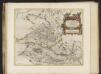
Tvedia cum vicecomitatu Etterico Forestae etiam Selkirkae dictus, [vulgo], Twee-dail with the Sherifdome of Etterik-Forest called also Selkirk / auct. Timotheo Pont.
Pont, Timothy, 1560?-1614? Blaeu, Joan, 1596-1673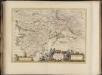
Glottiana Praefectura Superior, [vel], The Upper Ward of Clyds-dayl / Auct. Timoth. Pont.
Pont, Timothy, 1560?-1614? Blaeu, Joan, 1596-1673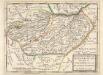
The North Part of ye Shire of Roxburgh and the Shire of Selkirk called also Etterick Forrest / by H. Moll.
Moll, Herman, d. 1732
GLOTTANIA | PRÆFECTVRA | SVPERIOR. [=] THE VPPER WARD | of | CLYDS-DAYL.
Auct. Timoth: Pont. [Amsterdam : Joan Blaeu]
TVEDIA | cum vicecomitatu Etterico Forestæ. | etiam Selkirke dictus | TWEE-DAIL | with the Sherifdome of Etterik-Forrest | called also Selkirk
Auct. Tomotheo Pont. [Amsterdam : Joan Blaeu]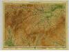
Border Country, Sheet 5 - Bartholomew's "Half Inch to the Mile Maps" of Scotland
1 : 126720 Topographic maps John Bartholomew & Son, Ltd John Bartholomew & Son, Ltd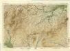
Moffat, Hawick & Border, Sheet 5 - Bartholomew's "Half Inch to the Mile Maps" of Scotland
1 : 126720 Topographic maps Bartholomew, John George John Bartholomew & Co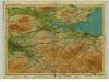
Forth, Sheet 8 - Bartholomew's "Half Inch to the Mile Maps" of Scotland
1 : 126720 Topographic maps John Bartholomew & Son, Ltd John Bartholomew & Son, Ltd