Maps of Scottish Borders

Border Country, Sheet 5 - Bartholomew's "Half Inch to the Mile Maps" of Scotland
1 : 126720 Topographic maps John Bartholomew & Son, Ltd John Bartholomew & Son, Ltd
Moffat, Hawick & Border, Sheet 5 - Bartholomew's "Half Inch to the Mile Maps" of Scotland
1 : 126720 Topographic maps Bartholomew, John George John Bartholomew & Co
The North Part of ye Shire of Roxburgh and the Shire of Selkirk called also Etterick Forrest / by H. Moll.
Moll, Herman, d. 1732
TEVIOTIA | Vulgo | TIVEDAIL
[Amsterdam : Joan Blaeu]
A map of Roxburghshire or Tiviotdale.
Stobie, Matthew, fl. 1758-1807
A map of Roxburghshire or Tiviotdale.
Stobie, Matthew, fl. 1758-1807
Map of the County of Roxburgh.
Tennant, N., fl. 1835-1850
A map of Roxburghshire or Tiviotdale.
Stobie, Matthew, fl. 1758-1807
A map of Roxburghshire or Tiviotdale.
Stobie, Matthew, fl. 1758-1807
Roxburghshire.
Thomson, John, 1777- ca. 1840 Crawford, William & Son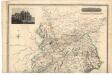
Roxburghshire.
Thomson, John, 1777- ca. 1840 Crawford, William & Son
Teviotia, Vulgo, Tivedail / auct. Tim. Pont, Io. Blaeu excudit.
Pont, Timothy, 1560?-1614? Blaeu, Joan, 1596-1673
Teviotia vulgo Tivedail
1 Karte : Kupferdruck ; 41 x 52 cm Blaeu; Pont Joan Blaeu
Selkirk - OS One-Inch Map
1 : 63360 Topographic maps Ordnance Survey Ordnance Survey
Jedburgh - OS One-Inch Map
1 : 63360 Topographic maps Ordnance Survey Ordnance Survey
Map embracing extensive portions of the Counties of Roxburgh, Berwick, Selkirk & Midlothian and Part of Northumberland. Minutely & accurately surveyed... by Crawford and Brooke
Crawford, William, 1793-ca.1845 Brooke, William, fl. 1835-47.
Map embracing extensive portions of the Counties of Roxburgh, Berwick, Selkirk & Midlothian and Part of Northumberland. Minutely & accurately surveyed... by Crawford and Brooke
Crawford, William, 1793-ca.1845 Brooke, William, fl. 1835-47.
Map embracing extensive portions of the Counties of Roxburgh, Berwick, Selkirk & Midlothian and Part of Northumberland. Minutely & accurately surveyed... by Crawford and Brooke
Crawford, William, 1793-ca.1845 Brooke, William, fl. 1835-47.
Map embracing extensive portions of the Counties of Roxburgh, Berwick, Selkirk & Midlothian and Part of Northumberland. Minutely & accurately surveyed... by Crawford and Brooke
Crawford, William, 1793-ca.1845 Brooke, William, fl. 1835-47.
Map embracing extensive portions of the Counties of Roxburgh, Berwick, Selkirk & Midlothian and Part of Northumberland. Minutely & accurately surveyed... by Crawford and Brooke
Crawford, William, 1793-ca.1845 Brooke, William, fl. 1835-47.
Map embracing extensive portions of the Counties of Roxburgh, Berwick, Selkirk & Midlothian and Part of Northumberland. Minutely & accurately surveyed... by Crawford and Brooke
Crawford, William, 1793-ca.1845 Brooke, William, fl. 1835-47.
Map embracing extensive portions of the Counties of Roxburgh, Berwick, Selkirk & Midlothian and Part of Northumberland. Minutely & accurately surveyed... by Crawford and Brooke
Crawford, William, 1793-ca.1845 Brooke, William, fl. 1835-47.
Map embracing extensive portions of the Counties of Roxburgh, Berwick, Selkirk & Midlothian and Part of Northumberland. Minutely & accurately surveyed... by Crawford and Brooke
Crawford, William, 1793-ca.1845 Brooke, William, fl. 1835-47.
Map embracing extensive portions of the Counties of Roxburgh, Berwick, Selkirk & Midlothian and Part of Northumberland. Minutely & accurately surveyed... by Crawford and Brooke
Crawford, William, 1793-ca.1845 Brooke, William, fl. 1835-47.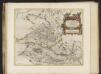
Tvedia cum vicecomitatu Etterico Forestae etiam Selkirkae dictus, [vulgo], Twee-dail with the Sherifdome of Etterik-Forest called also Selkirk / auct. Timotheo Pont.
Pont, Timothy, 1560?-1614? Blaeu, Joan, 1596-1673
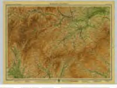
Cheviots - Bartholomew's 'Survey Atlas of Scotland'
1 : 126720 Topographic maps John Bartholomew & Son, Ltd John Bartholomew & Son, Ltd
Moffat - Bartholomew's 'Survey Atlas of Scotland'
1 : 126720 Topographic maps John Bartholomew & Son, Ltd John Bartholomew & Son, Ltd
Hawick & Eskdale (85) - OS One-Inch map
1 : 63360 Topographic maps Ordnance Survey Ordnance Survey
Hawick & Eskdale (85) - OS One-Inch map
1 : 63360 Topographic maps Ordnance Survey Ordnance Survey