Maps of East Ayrshire

Southern Part of Ayrshire.
Thomson, John, 1777- ca. 1840 Johnson, William, fl. 1806-1840
Northern Part of Ayrshire.
Thomson, John, 1777- ca. 1840 Johnson, William, fl. 1806-1840
Southern Part of Ayrshire.
Thomson, John, 1777- ca. 1840 Johnson, William, fl. 1806-1840
Northern Part of Ayrshire. Southern Part.
Thomson, John, 1777- ca. 1840 Johnson, William, fl. 1806-1840
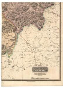
A new map of Ayrshire...
Armstrong, Andrew, 1700-1794
A new map of Ayrshire...
Armstrong, Andrew, 1700-1794
A new map of Ayrshire...
Armstrong, Andrew, 1700-1794
A new map of Ayrshire...
Armstrong, Andrew, 1700-1794
A new map of Ayrshire...
Armstrong, Andrew, 1700-1794
A new map of Ayrshire...
Armstrong, Andrew, 1700-1794
Composite: Ayrshire
1 : 78000 Johnson, William, fl. 1806-1840
The South Part of the Shire of Air [i.e. Ayr], containing Kyle and Carrick / by H. Moll.
Moll, Herman, d. 1732
Composite: Ayrshire S.
1 : 78000 Johnson, William, fl. 1806-1840
Ayr - Bartholomew's 'Survey Atlas of Scotland'
1 : 126720 Topographic maps John Bartholomew & Son, Ltd John Bartholomew & Son, Ltd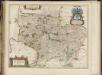
Coila Provincia, [or], The province of Kyle / auct. Timoth. Pont.
Pont, Timothy, 1560?-1614? Blaeu, Joan, 1596-1673
Ayr - OS One-Inch Map
1 : 63360 Topographic maps Ordnance Survey Ordnance Survey
Composite: Ayrshire N.
1 : 78000 Johnson, William, fl. 1806-1840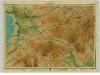
Ayrshire, Sheet 4 - Bartholomew's "Half Inch to the Mile Maps" of Scotland
1 : 126720 Topographic maps John Bartholomew & Son, Ltd John Bartholomew & Son, Ltd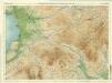
Ayr & Clydesdale, Sheet 4 - Bartholomew's "Half Inch to the Mile Maps" of Scotland
1 : 126720 Topographic maps Bartholomew, John George John Bartholomew & Co
COILA PROVINCIA. | THE PROVINCE OF| KYLE.
Auct. Timoth: Pont. [Amsterdam : Joan Blaeu]
Ayrshire 3 S.
1 : 78000 Thomson, John
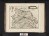
Caricta borealis vulgo the northpart of Carrick
1 Karte : Kupferdruck ; 41 x 51 cm Blaeu; Pont Joan Blaeu
CVNINGHAMIA.
Ex schedis | TIMOTHEO PONT. Ionnnes Blaeu excudebat
Coila provincia
1 Karte : Kupferdruck ; 44 x 55 cm Blaeu; Pont Joan Blaeu
Glasgow - Bartholomew's 'Survey Atlas of Scotland'
1 : 126720 Topographic maps John Bartholomew & Son, Ltd John Bartholomew & Son, Ltd
Ayrshire 1 N.
1 : 78000 Thomson, John
Girvan - OS One-Inch Map
1 : 63360 Topographic maps Ordnance Survey Ordnance Survey
Glasgow - OS One-Inch Map
1 : 63360 Topographic maps Ordnance Survey Ordnance Survey
CARICTA BOREALIS | Vulgo | The northpart of CARRICK.
Opus Timothei Pont. [Amsterdam : Joan Blaeu]