Maps of North Ayshire

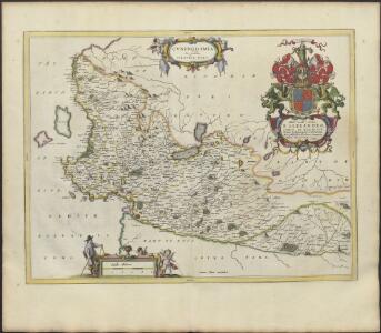
CVNINGHAMIA.
Ex schedis | TIMOTHEO PONT. Ionnnes Blaeu excudebat
Composite: Ayrshire N.
1 : 78000 Johnson, William, fl. 1806-1840
Glasgow - Bartholomew's 'Survey Atlas of Scotland'
1 : 126720 Topographic maps John Bartholomew & Son, Ltd John Bartholomew & Son, Ltd
Cvninghamia
1 Karte : Kupferdruck ; 41 x 54 cm Blaeu; Pont Joan Blaeu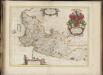
Cuninghamia / ex schedis Timotheo Pont ; Ioannis Blaeu excudebat. Cunningham.
Pont, Timothy, 1560?-1614? Blaeu, Joan, 1596-1673
The Shire of Renfrew with Cuningham [i.e. Cunningham]. The North Part of Air [i.e. Ayr] / by H. Moll.
Moll, Herman, d. 1732
Ayrshire 1 N.
1 : 78000 Thomson, John
Glasgow - OS One-Inch Map
1 : 63360 Topographic maps Ordnance Survey Ordnance Survey
PRÆFECTURA | RENFROANA | Vulgo dicta | BARONIA | THE BARONIE OF | RENFROW
Timotheus Pont Auctor. [Amsterdam : Joan Blaeu]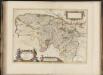
Praefectura Renfroana, vulgo, dicta Baronia. The Baronie of Renfrow / Timotheus Pont Auctor.
Pont, Timothy, 1560?-1614? Blaeu, Joan, 1596-1673
Renfrew Shire.
Thomson, John, 1777- ca. 1840
Map of the County of Renfrew.
Ainslie, John, 1745-1828
Map of the County of Renfrew.
Ainslie, John, 1745-1828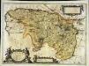
Præfectura Renfroana vulgo dicta Baronia
1 Karte : Kupferdruck ; 38 x 52 cm Blaeu; Pont Joan Blaeu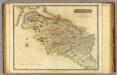
Renfrew-Shire.
1 : 73000 Thomson, John
Kilmarnock - OS One-Inch map
1 : 63360 Topographic maps Ordnance Survey Ordnance Survey
Kilmarnock - OS One-Inch map
1 : 63360 Topographic maps Ordnance Survey Ordnance Survey
Kilmarnock - OS One-Inch map
1 : 63360 Topographic maps Ordnance Survey Ordnance Survey
Glasgow (72) - OS One-Inch map
1 : 63360 Topographic maps Ordnance Survey Ordnance Survey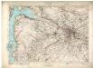
Glasgow (72) - OS One-Inch map
1 : 63360 Topographic maps Ordnance Survey Ordnance Survey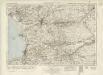
Kilmarnock & Ayr (78) - OS One-Inch map
1 : 63360 Topographic maps Ordnance Survey Ordnance Survey
Kilmarnock & Ayr (78) - OS One-Inch map
1 : 63360 Topographic maps Ordnance Survey Ordnance Survey
Ayrshire 2 N.
1 : 78000 Johnson, William, fl. 1806-1840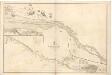
River Clyde from Dumbarton to Glasgow.
Great Britain. Hydrographic Office
Firth of Clyde, between Little Cumbrae and Toward Point
Great Britain. Hydrographic Office
Glasgow - OS One-Inch map
1 : 63360 Topographic maps Ordnance Survey Ordnance Survey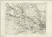
Glasgow - OS One-Inch map
1 : 63360 Topographic maps Ordnance Survey Ordnance Survey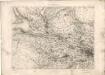
Glasgow - OS One-Inch map
1 : 63360 Topographic maps Ordnance Survey Ordnance Survey
Volume 1: Sheet 30 - Glasgow
1 : 63360 Farquharson, J.