Maps of South Kesteven
Lincolnshire CXL.14 (includes: Toft with Lound and Manthorpe; Witham on the Hill) - 25 Inch Map
1 : 2500 Topographic maps Ordnance Survey Ordnance Survey
Lincolnshire CXL.14 (includes: Toft with Lound and Manthorpe; Witham on the Hill) - 25 Inch Map
1 : 2500 Topographic maps Ordnance Survey Ordnance Survey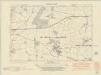
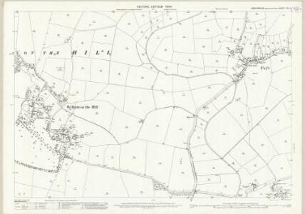
Lincolnshire CXL.SW - OS Six-Inch Map
1 : 10560 Topographic maps Ordnance Survey Ordnance Survey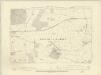
Lincolnshire CXL.SW - OS Six-Inch Map
1 : 10560 Topographic maps Ordnance Survey Ordnance Survey
Lincolnshire CXL.SW - OS Six-Inch Map
1 : 10560 Topographic maps Ordnance Survey Ordnance Survey
TF01 - OS 1:25,000 Provisional Series Map
1 : 25000 Topographic maps Ordnance Survey Ordnance Survey
Bourn (Hills) - OS One-Inch Revised New Series
1 : 63360 Topographic maps Ordnance Survey Ordnance Survey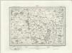
Bourn (Outline) - OS One-Inch Revised New Series
1 : 63360 Topographic maps Ordnance Survey Ordnance Survey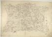
Corby
1 : 31680 This drawing covers parts of Northamptonshire and its neighbouring counties. Their boundaries are indicated by a red pecked line. The road running down the middle of the sheet is Ermine Street, the ancient Roman road from Chichester to York, passing through Lincolnshire. Right of centre is Grimsthorpe Park, with its avenues, trees, reservoir and lodge painstakingly illustrated. Boyce
RVTLANDIA | COMITATVS. | RVTLAND SHIRE.
[Amsterdam : Joan Blaeu]
Spalding
1 : 31680 This drawing covers part of Lincolnshire, showing drains across the fens highlighted in blue. These date from the 17th century, when James I appointed Dutch engineer Cornelius Vermuyden to direct the drainage of the wetlands. Many local people opposed the scheme as the plan involved commonland on which they grazed cattle. As a result of Vermuyden's work, the fens changed radically in appearance, from an area of flooded marshes to one of extensively farmed agricultural land. In the middle of the sheet is a series of decoy ponds, built in the 17th and 18th centuries to lure wildlife. Yeakell, Thomas Jr.
Rutlandia Comitatus. Rutland Shire. [Karte], in: Theatrum orbis terrarum, sive, Atlas novus, Bd. 4, S. 332.
1 Karte aus Atlas Blaeu, Joan Blaeu, Willem Janszoon
Rutlandia Comitatus. Rutland Shire. [Karte], in: Theatrum orbis terrarum, sive, Atlas novus, Bd. 4, S. 332.
1 Karte aus Atlas Blaeu, Joan Blaeu, Willem Janszoon
Rutlandia Comitatus. Rutland Shire. [Karte], in: Le théâtre du monde, ou, Nouvel atlas contenant les chartes et descriptions de tous les païs de la terre, Bd. 4, S. 290.
1 Karte aus Atlas Blaeu, Willem Janszoon und Blaeu, Joan Blaeu, Willem Janszoon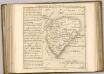

Spalding - OS One-Inch Map
1 : 63360 Topographic maps Ordnance Survey Ordnance Survey
Comitatis Cantabrigiensis; vernacule Cambridge Shire
1 Karte : Kupferdruck ; 40 x 50 cm Valck; Schenk venditant Gerardus Valk et Petrus Schenk
Lincoln Fens, Sheet 14 - Bartholomew's "Half Inch to the Mile Maps" of England & Wales
1 : 126720 Topographic maps Bartholomew, John George John Bartholomew & Co
Leicestrensis Comitatus cum Rutlandiae. Vulgo Leicester & Rutland Shire. [Karte], in: Novus atlas absolutissimus, Bd. 7, S. 316.
1 Karte aus Atlas Janssonius Offizin
Regiones Inundatae In finibus Comitatus Norfolciae, Suffolciae, Cantabrigiae, Huntingtoniae[,] Northamtoniae, et Lincolniae [Karte], in: Theatrum orbis terrarum, sive, Atlas novus, Bd. 4, S. 301.
1 Karte aus Atlas Blaeu, Joan Blaeu, Willem Janszoon
A general plott and description of the Fennes and surounded grounds in the sixe counties of Norfolke, Suffolke, Cambridge
1 Karte : Kupferdruck ; 44 x 55 cm Valck; Schenk sumptibus G. Valk et P. Schenk
Regiones invndatæ in finibus comitatus Norfolciæ, Svffolciæ, Cantabrigiæ, Hvntingtoniæ Northamtoniæ, et Lincolniæ
1 Karte : Kupferdruck ; 43 x 54 cm Blaeu Joan Blaeu
A general plott and description of the Fennes and surounded grounds in the sixe counties of Norfolke, Suffolke, Cambridge
1 Karte : Kupferdruck ; 44 x 55 cm Mercator; Hondius sumptibus Henrici Hondii
Regiones Inundatae In finibus Comitatus Norfolciae, Suffolciae, Cantabrigiae, Huntingtoniae[,] Northamtoniae, et Lincolniae [Karte], in: Theatrum orbis terrarum, sive, Atlas novus, Bd. 4, S. 301.
1 Karte aus Atlas Blaeu, Joan Blaeu, Willem Janszoon
CANTABRIGIENSIS | COMITATVS; | CAMBRIDGE SHIRE.
[Amsterdam : Joan Blaeu]
An accurate map of Northampton Shire
1 Karte : Kupferdruck ; 68 x 51 cm Bowen; Hinton sold by I. Hinton at the Kings Arms in Newgate street
Comitatvs Northantonensis vernacule Northamton Shire
1 Karte : Kupferdruck ; 37 x 49 cm Valck; Schenk prostant in officina penes Gerardi Valk et Petri Schenk
Comitatvs Northantonensis; vernacule Northamton Shire
1 Karte : Kupferdruck ; 40 x 48 cm Blaeu Joan Blaeu
Comitatis Cantabrigiensis, vernacule Cambridge Shire
1 : 210000 Amstelodami : apud Joannem Janssonium