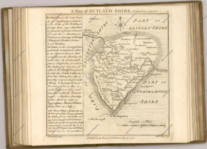
Maps of Rutland
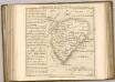

Rutlandia Comitatus. Rutland Shire. [Karte], in: Le théâtre du monde, ou, Nouvel atlas contenant les chartes et descriptions de tous les païs de la terre, Bd. 4, S. 290.
1 Karte aus Atlas Blaeu, Willem Janszoon und Blaeu, Joan Blaeu, Willem Janszoon
Rutlandia Comitatus. Rutland Shire. [Karte], in: Theatrum orbis terrarum, sive, Atlas novus, Bd. 4, S. 332.
1 Karte aus Atlas Blaeu, Joan Blaeu, Willem Janszoon
Rutlandia Comitatus. Rutland Shire. [Karte], in: Theatrum orbis terrarum, sive, Atlas novus, Bd. 4, S. 332.
1 Karte aus Atlas Blaeu, Joan Blaeu, Willem Janszoon
RVTLANDIA | COMITATVS. | RVTLAND SHIRE.
[Amsterdam : Joan Blaeu]
Rvtlandia comitatvs
1 Karte : Kupferdruck ; 37 x 48 cm Blaeu Joan Blaeu
Burton Overy
1 : 31680 Light brushwork interlining ('hachuring')is used to represent the gently undulating clay vales and ridges that make up much of the area covered by this drawing. Enclosed farmland dominates the landscape. There are only small areas of woodland, indicated by dark green washes. Leicester is shown at middle left along the Fosse Way, the Roman road from Exeter to Lincoln, via Bath, Cirencester, and Leicester. Stevens, Henry
Oakham
1 : 31680 .Burley Park, at the top of the plan, and Normanton Park, at middle right ,are interesting examples of the 17th-century development of formal park landscape, characterised by regular hedgerows and fishponds. At the top of the map, north of Oakham, is the Oakham Canal. An entirely manmade waterway, this circuitous canal was opened in 1803, and passes by many Rutland villages on its way from Melton Wharf to Oakham. Boyce
Stamford (Hills) - OS One-Inch Revised New Series
1 : 63360 Topographic maps Ordnance Survey Ordnance Survey
Stamford (Outline) - OS One-Inch Revised New Series
1 : 63360 Topographic maps Ordnance Survey Ordnance Survey
Corby
1 : 31680 This drawing covers parts of Northamptonshire and its neighbouring counties. Their boundaries are indicated by a red pecked line. The road running down the middle of the sheet is Ermine Street, the ancient Roman road from Chichester to York, passing through Lincolnshire. Right of centre is Grimsthorpe Park, with its avenues, trees, reservoir and lodge painstakingly illustrated. Boyce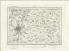
Leicester (Outline) - OS One-Inch Revised New Series
1 : 63360 Topographic maps Ordnance Survey Ordnance Survey
Leicester (Hills) - OS One-Inch Revised New Series
1 : 63360 Topographic maps Ordnance Survey Ordnance Survey
Kettering (Hills) - OS One-Inch Revised New Series
1 : 63360 Topographic maps Ordnance Survey Ordnance Survey
Kettering (Outline) - OS One-Inch Revised New Series
1 : 63360 Topographic maps Ordnance Survey Ordnance Survey
Melton Mowbray, Leicestershire
1 : 31680 This plan covers parts of Nottinghamshire, Leicestershire and Rutland, with the county borders indicated by a red dotted line. Down the left of the sheet is depicted the Fosse Way, the Roman road running from Exeter to Lincoln, via Bath, Cirencester, and Leicester. The Oakham Canal is shown following the course of the River Eye at middle right. Surveyed by Benjamin Bevan and opened in 1803, this entirely man-made waterway passed many Rutland villages on its circuitous route from Melton Mowbray to Oakham. Boyce
Bourn (Hills) - OS One-Inch Revised New Series
1 : 63360 Topographic maps Ordnance Survey Ordnance Survey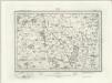
Bourn (Outline) - OS One-Inch Revised New Series
1 : 63360 Topographic maps Ordnance Survey Ordnance Survey
Stamford
This plan details a section of the Welland and Nene Valleys running through Cambridgeshire and Lincolnshire. It depicts the system of man-made drains, ditches and sluices for draining the lowland area between Peterborough and Ely, offering a navigable route to the fenland rivers. Milton Park at the bottom right is a good example of 18th-century formal parkland, with grass, trees and lakes well detailed. Boyce
Stamford
1 : 31680 .This plan details a section of the Welland and Nene Valleys running through Cambridgeshire and Lincolnshire., It depicts the system of man-made drains, ditches and sluices,for draining the lowland area between Peterborough and Ely, offering a navigable route to the fenland rivers., Milton Park at the bottom right is a good example of 18th-century formal parkland, with grass, trees and lakes well detailed. Boyce
Market Harborough (Hills) - OS One-Inch Revised New Series
1 : 63360 Topographic maps Ordnance Survey Ordnance Survey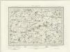
Market Harborough (Outline) - OS One-Inch Revised New Series
1 : 63360 Topographic maps Ordnance Survey Ordnance Survey
TF01 - OS 1:25,000 Provisional Series Map
1 : 25000 Topographic maps Ordnance Survey Ordnance Survey
TF00 - OS 1:25,000 Provisional Series Map
1 : 25000 Topographic maps Ordnance Survey Ordnance Survey
TL09 - OS 1:25,000 Provisional Series Map
1 : 25000 Topographic maps Ordnance Survey Ordnance Survey
SK91 - OS 1:25,000 Provisional Series Map
1 : 25000 Topographic maps Ordnance Survey Ordnance Survey
SK90 - OS 1:25,000 Provisional Series Map
1 : 25000 Topographic maps Ordnance Survey Ordnance Survey
SP99 - OS 1:25,000 Provisional Series Map
1 : 25000 Topographic maps Ordnance Survey Ordnance Survey
SK81 - OS 1:25,000 Provisional Series Map
1 : 25000 Topographic maps Ordnance Survey Ordnance Survey