Maps of Aylesbury Vale
Buckinghamshire XXIV.13 (includes: Aston Abbots; Wingrave with Rowsham) - 25 Inch Map
1 : 2500 Topographic maps Ordnance Survey Ordnance Survey
Buckinghamshire XXIV.13 (includes: Aston Abbots; Wingrave with Rowsham) - 25 Inch Map
1 : 2500 Topographic maps Ordnance Survey Ordnance Survey
Buckinghamshire XXIV.13 (includes: Aston Abbots; Wingrave with Rowsham) - 25 Inch Map
1 : 2500 Topographic maps Ordnance Survey Ordnance Survey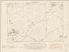
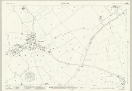
Buckinghamshire XXIV.SW - OS Six-Inch Map
1 : 10560 Topographic maps Ordnance Survey Ordnance Survey
Buckinghamshire XXIV.SW - OS Six-Inch Map
1 : 10560 Topographic maps Ordnance Survey Ordnance Survey
Buckinghamshire XXIV.SW - OS Six-Inch Map
1 : 10560 Topographic maps Ordnance Survey Ordnance Survey
Buckinghamshire XXIV.SW - OS Six-Inch Map
1 : 10560 Topographic maps Ordnance Survey Ordnance Survey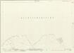
Hertfordshire XVII.9 & XVI.12 (includes: Mentmore; Tring Rural; Wing; Wingrave with Rowsham) - 25 Inch Map
1 : 2500 Topographic maps Ordnance Survey Ordnance Survey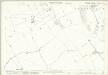
Hertfordshire XVII.9 & XVI.12 (includes: Mentmore; Tring Rural; Wing; Wingrave with Rowsham) - 25 Inch Map
1 : 2500 Topographic maps Ordnance Survey Ordnance Survey
Buckinghamshire XXIV - OS Six-Inch Map
1 : 10560 Topographic maps Ordnance Survey Ordnance Survey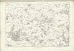
Hertfordshire XXIV (inset XVI) - OS Six-Inch Map
1 : 10560 Topographic maps Ordnance Survey Ordnance Survey
Leighton Buzzard (Hills) - OS One-Inch Revised New Series
1 : 63360 Topographic maps Ordnance Survey Ordnance Survey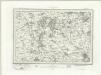
Leighton Buzzard (Outline) - OS One-Inch Revised New Series
1 : 63360 Topographic maps Ordnance Survey Ordnance Survey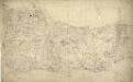
Tring
1 : 31680 This field sketch describes the chalk hills of the Chilterns, including a section of the Grand Junction and the Aylesbury Canals. Some field boundaries on this drawing have been revised and corrected in red ink which suggests they,should be read as accurate delineations plotted from surveyed measurements.,A reservoir,located just above Wendover was also inserted at a later date. , Boyce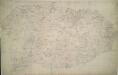
Winslow
1 : 31680 Enclosed farmland characterises the landscape of this part of Buckinghamshire. To the right of the manuscript, a section of the Grand Junction Canal is depicted running from Leighton Buzzard to Fenny Strafford along the River Fosse Valley. Two Roman roads are depicted on the plan: the Watling Street from London to Wroxeter in Wales via St. Albans and Leicester, at top right, and the Akeman Street Way, at lower left. Boyce
London passenger transport map
Ordnance Survey
Woburn
1 : 31680 This county boundary of Bedfordshire and Buckinghamshire is depicted as a black dotted line at bottom left. Down the right of the sheet, many triangulation points are marked in red ink. Toll roads are highlighted in yellow, with turnpikes indicated along their routes. A section of the Watling Street, between Dunstable and Little Brickhill, is indicated near the bottom of the sheet. This Roman road ran from London to Wroxeter in Wales, via St. Albans. Symbols distinguish different types land use, while shading is used to indicate relief. Hyett, William
The Chilterns
1 : 63360 Ordnance Survey Office
Buckingham - OS One-Inch Map
1 : 63360 Topographic maps Ordnance Survey Ordnance Survey
The Chilterns - OS One-Inch Map
1 : 63360 Topographic maps Ordnance Survey Ordnance Survey
[Left] BEDFORDIENSIS | COMITATVS; | Anglis | BEDFORD SHIRE. [right] BVCKINGHAMI- | ENSIS COMITATVS; | Anglis | BUCKINGHAM SHIRE.
[Amsterdam : Joan Blaeu]
Bedfordiensis Comitatus; Anglis Bedford Shire. [Karte], in: Le théâtre du monde, ou, Nouvel atlas contenant les chartes et descriptions de tous les païs de la terre, Bd. 4, S. 218.
1 Karte aus Atlas Blaeu, Willem Janszoon und Blaeu, Joan Blaeu, Willem Janszoon
HARTFORDIAE COMITATUS Sheet 13
This map of Hertfordshire is from the 1583 edition of the Saxton atlas of England and Wales. This atlas was first published as a whole in 1579. It consists of 35 coloured maps depicting the counties of England and Wales. The atlas is of great significance to British cartography as it set a standard of cartographic representation in Britain and the maps remained the basis for English county mapping, with few exceptions, until after 1750. During the reign of Elizabeth I map use became more common, with many government matters referring to increasingly accurate maps with consistent scales and symbols, made possible by advances in surveying techniques. Illustrating the increasing used of maps in government matters, Lord Burghley, Elizabeth I’s Secretary of State, who had been determined to have England and Wales mapped in detail from the 1550s, selected the cartographer Christopher Saxton to produce a detailed and consistent survey of the country. The financier of the project was Thomas Seckford Master of Requests at the Court of Elizabeth I, whose arms appear, along with the royal crest, on each map. A decorative scale bar houses Saxton’s name and the name of the engraver Remigius Hogenberg, one of seven English and Flemish engravers employed to produce the copper plates for the atlas. Relief, in the form of uniform rounded representations of hills, is the main topographical feature presented in the maps. Rather than provide a scientific representation of relative relief these give a general impression of the lie of the land. Settlements and notable buildings are also recorded pictorially; a small building with a spire represents a village, while more important towns, such as Hereford are indicated by groups of buildings. Saxton, Christopher Ryther, Augustine
HERTFORDIA | COMITATVS. | Vernacule | HERTFORDSHIRE.
[Amsterdam : Joan Blaeu]
Bedfordiensis Comitatus; Anglis Bedford Shire. [Karte], in: Theatrum orbis terrarum, sive, Atlas novus, Bd. 4, S. 246.
1 Karte aus Atlas Blaeu, Joan Blaeu, Willem Janszoon
Bedfordiensis Comitatus; Anglis Bedford Shire. [Karte], in: Theatrum orbis terrarum, sive, Atlas novus, Bd. 4, S. 246.
1 Karte aus Atlas Blaeu, Joan Blaeu, Willem Janszoon
An accurate map of Buckingham Shire
1 Karte : Kupferdruck ; 69 x 52 cm Bowen; Tinney; Bowles; Sayer; Bowles; Bowles sold by I. Tinney at the golden lion and R. Sayer at the golden buck in Fleet street T. Bowles in St. Pauls Church yard and I. Bowles and son in Cornhill
REGIONIS, qvae est circa LONDINVM, specialis repraesentatio geographica
1 : 190000 Bowles, Thomas curantibus Homan[n]ianis Heredibus
Hertfordia Comitatus. Vernacule Hertfordshire [Karte], in: Theatrum orbis terrarum, sive, Atlas novus, Bd. 4, S. 254.
1 Karte aus Atlas Blaeu, Joan Blaeu, Willem Janszoon