Maps of Lincolnshire
Lincolnshire LXXXVII.SE - OS Six-Inch Map
1 : 10560 Topographic maps Ordnance Survey Ordnance Survey
Lincolnshire LXXXVII.SE - OS Six-Inch Map
1 : 10560 Topographic maps Ordnance Survey Ordnance Survey
Lincolnshire LXXXVII.SE - OS Six-Inch Map
1 : 10560 Topographic maps Ordnance Survey Ordnance Survey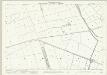
Lincolnshire LXXXVII.16 (includes: Digby; Rowston; Walcot Near Billinghay) - 25 Inch Map
1 : 2500 Topographic maps Ordnance Survey Ordnance Survey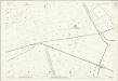
Lincolnshire LXXXVII.16 (includes: Digby; Rowston; Walcot Near Billinghay) - 25 Inch Map
1 : 2500 Topographic maps Ordnance Survey Ordnance Survey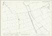
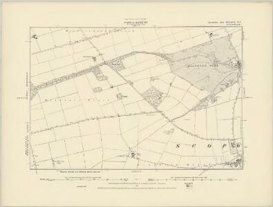
Lincolnshire LXXXVII.12 (includes: Rowston; Scopwick; Timberland; Walcot Near Billinghay) - 25 Inch Map
1 : 2500 Topographic maps Ordnance Survey Ordnance Survey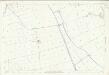
Lincolnshire LXXXVII.12 (includes: Rowston; Scopwick; Timberland; Walcot Near Billinghay) - 25 Inch Map
1 : 2500 Topographic maps Ordnance Survey Ordnance Survey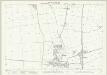
Lincolnshire LXXXVII.15 (includes: Ashby De La Launde and Bloxholm; Digby; Dorrington; Rowston) - 25 Inch Map
1 : 2500 Topographic maps Ordnance Survey Ordnance Survey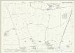
Lincolnshire LXXXVII.11 (includes: Rowston; Scopwick) - 25 Inch Map
1 : 2500 Topographic maps Ordnance Survey Ordnance Survey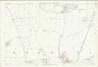
Lincolnshire LXXXVII.11 (includes: Rowston; Scopwick) - 25 Inch Map
1 : 2500 Topographic maps Ordnance Survey Ordnance Survey
TF05 - OS 1:25,000 Provisional Series Map
1 : 25000 Topographic maps Ordnance Survey Ordnance Survey
Timberland
1 : 31680 Long, straight cattle droves are a feature of this part of Lincolnshire and are depicted to the right of the sheet near the dykes and canals constructed to drain the fens. These date from the 17th century, when James I appointed Dutch engineer Cornelius Vermuyden to direct the drainage of the wetlands. Many local people opposed the scheme as the plan involved commonland on which they grazed cattle. As a result of Vermuyden's work, the fens changed radically in appearance, from an area of flooded marshes to one of extensively farmed agricultural land. Budgen, Charles
Lincoln (Hills) - OS One-Inch Revised New Series
1 : 63360 Topographic maps Ordnance Survey Ordnance Survey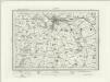
Lincoln (Outline) - OS One-Inch Revised New Series
1 : 63360 Topographic maps Ordnance Survey Ordnance Survey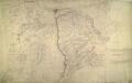
Lincoln
1 : 31680 This drawing shows the county boundary of Lincolnshire and Nottinghamshire as a red dotted line down the left of the sheet. The county town is depicted at the top of the plan on the north bank of the river Witham, set on the summit of the limestone ridge known as the Cliff Hills. Water-filled dykes, constructed to drain the fens, are represented to the right of the sheet, together with the ancient cattle droves, long straight roads that characterise this part of the Lincolnshire landscape. Stevens, Henry
Lincon and Grantham - OS One-Inch Map
1 : 63360 Topographic maps Ordnance Survey Ordnance Survey
Lincoln Fens, Sheet 14 - Bartholomew's "Half Inch to the Mile Maps" of England & Wales
1 : 126720 Topographic maps Bartholomew, John George John Bartholomew & Co
COMITATVS | NOTTINGHA- | MIENSIS; | NOTTINGHAM SHIRE.
[Amsterdam : Joan Blaeu]
Comitatus Nottinghamiensis, sive Nottingham Shire
1 : 240000 [Amstelodami] : [apud Joannem Janssonium]
Sheets 42-43. (Cary's England, Wales, and Scotland).
1 : 360000 Cary, John, ca. 1754-1835
Comitatus Nottinghamiensis; Sive Nottingham Shire. [Karte], in: Novus atlas absolutissimus, Bd. 7, S. 334.
1 Karte aus Atlas Janssonius Offizin
Lincolnia comitatus : Anglis Lincoln-Shire
1 : 253000

Comitatus Nottinghamiensis; Nottingham Shire. [Karte], in: Le théâtre du monde, ou, Nouvel atlas contenant les chartes et descriptions de tous les païs de la terre, Bd. 4, S. 302.
1 Karte aus Atlas Blaeu, Willem Janszoon und Blaeu, Joan Blaeu, Willem Janszoon
Comitatus Nottinghamiensis; Nottingham Shire. [Karte], in: Theatrum orbis terrarum, sive, Atlas novus, Bd. 4, S. 346.
1 Karte aus Atlas Blaeu, Joan Blaeu, Willem Janszoon
Comitatus Nottinghamiensis; Nottingham Shire. [Karte], in: Theatrum orbis terrarum, sive, Atlas novus, Bd. 4, S. 346.
1 Karte aus Atlas Blaeu, Joan Blaeu, Willem Janszoon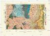
Geological Survey of England and Wales
1 : 409000 Anglie Ordnance Survey Office
An accurate map of Lincolnshire
1 Karte : Kupferdruck ; 68 x 51 cm Bowen; Hinton sold by J. Hinton at the Kings Arms in St. Pauls Church Yard
Lincolnia comitatvs anglis Lincoln-Shire
1 Karte : Kupferdruck ; 40 x 48 cm Blaeu Joan Blaeu