Maps of Lincolnshire
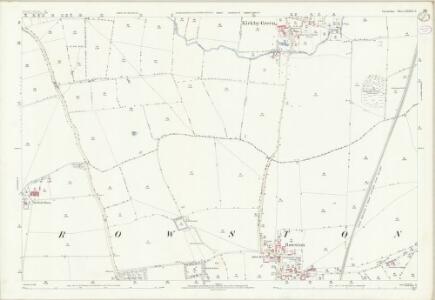
Lincolnshire LXXXVII.11 (includes: Rowston; Scopwick) - 25 Inch Map
1 : 2500 Topographic maps Ordnance Survey Ordnance Survey
Lincolnshire LXXXVII.11 (includes: Rowston; Scopwick) - 25 Inch Map
1 : 2500 Topographic maps Ordnance Survey Ordnance Survey
Lincolnshire LXXXVII.SE - OS Six-Inch Map
1 : 10560 Topographic maps Ordnance Survey Ordnance Survey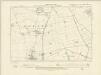
Lincolnshire LXXXVII.SE - OS Six-Inch Map
1 : 10560 Topographic maps Ordnance Survey Ordnance Survey
Lincolnshire LXXXVII.SE - OS Six-Inch Map
1 : 10560 Topographic maps Ordnance Survey Ordnance Survey
TF05 - OS 1:25,000 Provisional Series Map
1 : 25000 Topographic maps Ordnance Survey Ordnance Survey
Timberland
1 : 31680 Long, straight cattle droves are a feature of this part of Lincolnshire and are depicted to the right of the sheet near the dykes and canals constructed to drain the fens. These date from the 17th century, when James I appointed Dutch engineer Cornelius Vermuyden to direct the drainage of the wetlands. Many local people opposed the scheme as the plan involved commonland on which they grazed cattle. As a result of Vermuyden's work, the fens changed radically in appearance, from an area of flooded marshes to one of extensively farmed agricultural land. Budgen, Charles
Lincoln (Hills) - OS One-Inch Revised New Series
1 : 63360 Topographic maps Ordnance Survey Ordnance Survey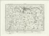
Lincoln (Outline) - OS One-Inch Revised New Series
1 : 63360 Topographic maps Ordnance Survey Ordnance Survey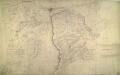
Lincoln
1 : 31680 This drawing shows the county boundary of Lincolnshire and Nottinghamshire as a red dotted line down the left of the sheet. The county town is depicted at the top of the plan on the north bank of the river Witham, set on the summit of the limestone ridge known as the Cliff Hills. Water-filled dykes, constructed to drain the fens, are represented to the right of the sheet, together with the ancient cattle droves, long straight roads that characterise this part of the Lincolnshire landscape. Stevens, Henry
Lincon and Grantham - OS One-Inch Map
1 : 63360 Topographic maps Ordnance Survey Ordnance Survey
Lincoln Fens, Sheet 14 - Bartholomew's "Half Inch to the Mile Maps" of England & Wales
1 : 126720 Topographic maps Bartholomew, John George John Bartholomew & Co
COMITATVS | NOTTINGHA- | MIENSIS; | NOTTINGHAM SHIRE.
[Amsterdam : Joan Blaeu]
Comitatus Nottinghamiensis, sive Nottingham Shire
1 : 240000 [Amstelodami] : [apud Joannem Janssonium]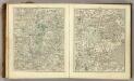
Sheets 42-43. (Cary's England, Wales, and Scotland).
1 : 360000 Cary, John, ca. 1754-1835
Comitatus Nottinghamiensis; Sive Nottingham Shire. [Karte], in: Novus atlas absolutissimus, Bd. 7, S. 334.
1 Karte aus Atlas Janssonius Offizin
Lincolnia comitatus : Anglis Lincoln-Shire
1 : 253000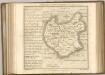

Comitatus Nottinghamiensis; Nottingham Shire. [Karte], in: Le théâtre du monde, ou, Nouvel atlas contenant les chartes et descriptions de tous les païs de la terre, Bd. 4, S. 302.
1 Karte aus Atlas Blaeu, Willem Janszoon und Blaeu, Joan Blaeu, Willem Janszoon
Comitatus Nottinghamiensis; Nottingham Shire. [Karte], in: Theatrum orbis terrarum, sive, Atlas novus, Bd. 4, S. 346.
1 Karte aus Atlas Blaeu, Joan Blaeu, Willem Janszoon
Comitatus Nottinghamiensis; Nottingham Shire. [Karte], in: Theatrum orbis terrarum, sive, Atlas novus, Bd. 4, S. 346.
1 Karte aus Atlas Blaeu, Joan Blaeu, Willem Janszoon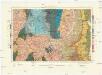
Geological Survey of England and Wales
1 : 409000 Anglie Ordnance Survey Office
An accurate map of Lincolnshire
1 Karte : Kupferdruck ; 68 x 51 cm Bowen; Hinton sold by J. Hinton at the Kings Arms in St. Pauls Church Yard
Lincolnia comitatvs anglis Lincoln-Shire
1 Karte : Kupferdruck ; 40 x 48 cm Blaeu Joan Blaeu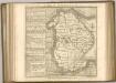

LINCOLNIAE NOTINGHAMMIAE Comitatuu
This map of Lincolnshire and Nottinghamshire is from the 1583 edition of the Saxton atlas of England and Wales. This atlas was first published as a whole in 1579. It consists of 35 coloured maps depicting the counties of England and Wales. The atlas is of great significance to British cartography as it set a standard of cartographic representation in Britain and the maps remained the basis for English county mapping, with few exceptions, until after 1750. During the reign of Elizabeth I map use became more common, with many government matters referring to increasingly accurate maps with consistent scales and symbols, made possible by advances in surveying techniques. Illustrating the increasing used of maps in government matters, Lord Burghley, Elizabeth I’s Secretary of State, who had been determined to have England and Wales mapped in detail from the 1550s, selected the cartographer Christopher Saxton to produce a detailed and consistent survey of the country. The financier of the project was Thomas Seckford Master of Requests at the Court of Elizabeth I, whose arms appear, along with the royal crest, on each map. A decorative scale bar holds Saxton’s name and also that of the engraver of this map, engraver Remigius Hogenberg, one of seven English and Flemish engravers employed to produce the copper plates for the atlas. Relief, in the form of uniform rounded representations of hills, is the main topographical feature presented in the maps. Rather than provide a scientific representation of relative relief these give a general impression of the lie of the land. Settlements and notable buildings are also recorded pictorially; a small building with a spire represents a village, while more important towns, such as Hereford are indicated by groups of buildings. Saxton, Christopher Ryther, Augustine
Sheet 6 Eastern Counties (N.), uit: Maps of England & Wales : scale 4 miles to 1 inch / Ordnance Survey
1 : 253440 titelvariant: Maps of England and Wales; Annotatie: Titel op cassette; Met bladoverzicht op de achterzijde van de cassette; Annotatie geografische gegevens: Hoogtelijneninterval 200 ft Ordnance Survey, United Kingdom Southampton : Ordnance Survey Office
LINCOLNIAE NOTINGHHAMIAQUE Comitatum
This is a map of Lincolnshire and Nottinghamshire by Christopher Saxton, dating from 1576. It forms part of an atlas that belonged to William Cecil Lord Burghley, Elizabeth I’s Secretary of State. Lord Burghley used this atlas to illustrate domestic matters. This map is actually a proof copy of one which forms part of Christopher Saxton’s Atlas of England and Wales. This atlas was first published as a whole in 1579. It consists of 35 coloured maps depicting the counties of England and Wales. The atlas is of great significance to British cartography as it set a standard of cartographic representation in Britain and the maps remained the basis for English county mapping, with few exceptions, until after 1750. During the reign of Elizabeth I map use became more common, with many government matters referring to increasingly accurate maps with consistent scales and symbols, made possible by advances in surveying techniques. Illustrating the increasing used of maps in government matters, Lord Burghley, who had been determined to have England and Wales mapped in detail from the 1550s, selected the cartographer Christopher Saxton to produce a detailed and consistent survey of the country. The financier of the project was Thomas Seckford Master of Requests at the Court of Elizabeth I, whose arms appear, along with the royal crest, on each map. Burghley has annotated this map, adding place names adjacent to the tributaries of the Humber. A battle is depicted at the mouth of the Humber, perhaps reflecting the military importance of Hull which was heavily fortified by Henry VIII and then repaired during the Elizabethan period in readiness for the threatened Spanish invasion. The map was engraved by Remigius Hogenbergius, one of a team of seven English and Flemish engravers employed to produce the copper plates for the atlas. Saxton, Christopher Hogenbergius, Remigius
LINCOLNIA | COMITATVS. Anglis | LINCOLN-SHIRE.
[Amsterdam : Joan Blaeu]