Maps of Northamptonshire

Leicestrensis Comitatus. Leicester Shire. [Karte], in: Theatrum orbis terrarum, sive, Atlas novus, Bd. 4, S. 327.
1 Karte aus Atlas Blaeu, Joan Blaeu, Willem Janszoon
Leicestrensis Comitatus. Leicester Shire. [Karte], in: Theatrum orbis terrarum, sive, Atlas novus, Bd. 4, S. 327.
1 Karte aus Atlas Blaeu, Joan Blaeu, Willem Janszoon
Leicestrensis Comitatus. Leicester Shire. [Karte], in: Le théâtre du monde, ou, Nouvel atlas contenant les chartes et descriptions de tous les païs de la terre, Bd. 4, S. 287.
1 Karte aus Atlas Blaeu, Willem Janszoon und Blaeu, Joan Blaeu, Willem Janszoon
Leicestrensis Comitatus cum Rutlandiae. Vulgo Leicester & Rutland Shire. [Karte], in: Novus atlas absolutissimus, Bd. 7, S. 316.
1 Karte aus Atlas Janssonius Offizin
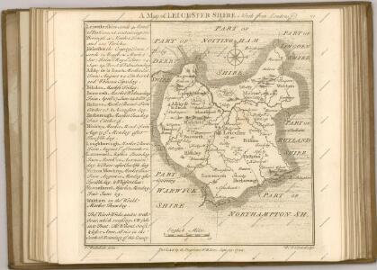
LEICESTRENSIS | COMITATVS. | LEICESTER SHIRE.
[Amsterdam : Joan Blaeu]
An accurate map of the counties of Leicester and Rutland
1 Karte : Kupferdruck ; 52 x 68 cm Bowen; Tinney; Bowles; Sayer; Bowles; Bowles printed for I. Tinney at the Golden Lion and R. Sayer at the Golden Buck in Fleet street T. Bowles in St. Paul's Church yard and I. Bowles and son at the Black Horse in Cornhill
Leicestrensis comitatvs cum Rvtlandiæ vulgo Leicester [and] Rutland Shire
1 Karte : Kupferdruck ; 42 x 52 cm Valck; Schenk penes Gerardum Valk et Petrum Schenk
Leicestrensis Comitatus cum Rutlandiae vulgo Leicester & Rutland Shire
1 : 160000 Amstelodami : ex. Joannes Janssonius
Leicestrensis comitatvs
1 Karte : Kupferdruck ; 37 x 48 cm Blaeu Joan Blaeu
Birmingham, Leicester, Sheet 18 - Bartholomew's "Half Inch to the Mile Maps" of England & Wales
1 : 126720 Topographic maps Bartholomew, John George John Bartholomew & Co
Derby & Nottingham, Sheet 13 - Bartholomew's "Half Inch to the Mile Maps" of England & Wales
1 : 126720 Topographic maps Bartholomew, John George John Bartholomew & Co
The counti of Warwick the shire towne and citie of Coventre described
1 : 1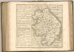

Melton Mowbray - OS One-Inch Map
1 : 63360 Topographic maps Ordnance Survey Ordnance Survey
Derby and Leicester - OS One-Inch Map
1 : 63360 Topographic maps Ordnance Survey Ordnance Survey
Burton upon Trent - OS One-Inch Map
1 : 63360 Topographic maps Ordnance Survey Ordnance Survey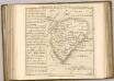

Coventry and Rugby - OS One-Inch Map
1 : 63360 Topographic maps Ordnance Survey Ordnance Survey
Northampton - OS One-Inch Map
1 : 63360 Topographic maps Ordnance Survey Ordnance Survey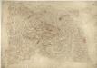
Leicester and Loughborough
1 : 31680 This plan covers part of Leicestershire, with the River Soar Valley forming the right-hand margin. In the middle of the sheet, the rocky peaks of Charnwood Forest are represented rising above the Leicestershire lowlands. Areas of ancient woodland and a significant proportion of wet woodland comprise the forest landscape. The underlying rocks are some of the oldest in England and Wales. The City of Leicester is depicted at middle-right along the banks of the Soar. Stevens, Henry
Rutlandia Comitatus. Rutland Shire. [Karte], in: Theatrum orbis terrarum, sive, Atlas novus, Bd. 4, S. 332.
1 Karte aus Atlas Blaeu, Joan Blaeu, Willem Janszoon
Rutlandia Comitatus. Rutland Shire. [Karte], in: Theatrum orbis terrarum, sive, Atlas novus, Bd. 4, S. 332.
1 Karte aus Atlas Blaeu, Joan Blaeu, Willem Janszoon
Rutlandia Comitatus. Rutland Shire. [Karte], in: Le théâtre du monde, ou, Nouvel atlas contenant les chartes et descriptions de tous les païs de la terre, Bd. 4, S. 290.
1 Karte aus Atlas Blaeu, Willem Janszoon und Blaeu, Joan Blaeu, Willem Janszoon
RVTLANDIA | COMITATVS. | RVTLAND SHIRE.
[Amsterdam : Joan Blaeu]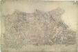
Sutton Coldfield
1 : 31680 This drawing of the area north-east of Birmingham was executed by Robert Dawson, who used different shades of green to distinguish land uses. Sutton Coldfield is depicted at lower right. Now a residential suburb of Birmingham, it was originally a market town with Sutton Park. The 970-hectare site was a private estate and one of Henry VIII's favourite hunting grounds. Areas of woodland, heathland and wetland make up the landscape of the park. Dawson, Robert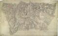
Birmingham 24
1 : 31680 This drawing is attributed to Robert Dawson. Different shades of green are employed to distinguish different land uses, and darker tones to describe the bold undulation of the landscape. Birmingham is depicted top left, at the centre of a network of toll roads and canals. Prominently featured on the plan is the Grand Junction Canal. This waterway was at the heart of the Industrial Revolution in this region at the beginning of the 19th century, carrying raw materials to mills and industrial centres, and finished goods to markets throughout Britain. Dawson, Robert
Grantham 24
1 : 31680 This drawing depicts the county boundary of Lincolnshire and Leicestershire as a red dotted line at lower left. The Ermine Street (or High Dyke) is shown running down the right of the sheet. This Roman road extended from Cichester in Sussex to York, passing through Lincolnshire. At lower left, in the Vale of Belvoir, the villages of Plungar, Redmile, Bottesford and Muston are recorded along the Grantham Canal, along with the prominent Belvoir Castle. Budgen, Charles
Melton Mowbray, Leicestershire
1 : 31680 This plan covers parts of Nottinghamshire, Leicestershire and Rutland, with the county borders indicated by a red dotted line. Down the left of the sheet is depicted the Fosse Way, the Roman road running from Exeter to Lincoln, via Bath, Cirencester, and Leicester. The Oakham Canal is shown following the course of the River Eye at middle right. Surveyed by Benjamin Bevan and opened in 1803, this entirely man-made waterway passed many Rutland villages on its circuitous route from Melton Mowbray to Oakham. Boyce