Maps of Lincolnshire

An accurate map of Lincolnshire
1 Karte : Kupferdruck ; 68 x 51 cm Bowen; Hinton sold by J. Hinton at the Kings Arms in St. Pauls Church Yard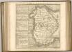

Lincolnia comitatvs anglis Lincoln-Shire
1 Karte : Kupferdruck ; 40 x 48 cm Blaeu Joan Blaeu
LINCOLNIAE NOTINGHAMMIAE Comitatuu
This map of Lincolnshire and Nottinghamshire is from the 1583 edition of the Saxton atlas of England and Wales. This atlas was first published as a whole in 1579. It consists of 35 coloured maps depicting the counties of England and Wales. The atlas is of great significance to British cartography as it set a standard of cartographic representation in Britain and the maps remained the basis for English county mapping, with few exceptions, until after 1750. During the reign of Elizabeth I map use became more common, with many government matters referring to increasingly accurate maps with consistent scales and symbols, made possible by advances in surveying techniques. Illustrating the increasing used of maps in government matters, Lord Burghley, Elizabeth I’s Secretary of State, who had been determined to have England and Wales mapped in detail from the 1550s, selected the cartographer Christopher Saxton to produce a detailed and consistent survey of the country. The financier of the project was Thomas Seckford Master of Requests at the Court of Elizabeth I, whose arms appear, along with the royal crest, on each map. A decorative scale bar holds Saxton’s name and also that of the engraver of this map, engraver Remigius Hogenberg, one of seven English and Flemish engravers employed to produce the copper plates for the atlas. Relief, in the form of uniform rounded representations of hills, is the main topographical feature presented in the maps. Rather than provide a scientific representation of relative relief these give a general impression of the lie of the land. Settlements and notable buildings are also recorded pictorially; a small building with a spire represents a village, while more important towns, such as Hereford are indicated by groups of buildings. Saxton, Christopher Ryther, Augustine
LINCOLNIAE NOTINGHHAMIAQUE Comitatum
This is a map of Lincolnshire and Nottinghamshire by Christopher Saxton, dating from 1576. It forms part of an atlas that belonged to William Cecil Lord Burghley, Elizabeth I’s Secretary of State. Lord Burghley used this atlas to illustrate domestic matters. This map is actually a proof copy of one which forms part of Christopher Saxton’s Atlas of England and Wales. This atlas was first published as a whole in 1579. It consists of 35 coloured maps depicting the counties of England and Wales. The atlas is of great significance to British cartography as it set a standard of cartographic representation in Britain and the maps remained the basis for English county mapping, with few exceptions, until after 1750. During the reign of Elizabeth I map use became more common, with many government matters referring to increasingly accurate maps with consistent scales and symbols, made possible by advances in surveying techniques. Illustrating the increasing used of maps in government matters, Lord Burghley, who had been determined to have England and Wales mapped in detail from the 1550s, selected the cartographer Christopher Saxton to produce a detailed and consistent survey of the country. The financier of the project was Thomas Seckford Master of Requests at the Court of Elizabeth I, whose arms appear, along with the royal crest, on each map. Burghley has annotated this map, adding place names adjacent to the tributaries of the Humber. A battle is depicted at the mouth of the Humber, perhaps reflecting the military importance of Hull which was heavily fortified by Henry VIII and then repaired during the Elizabethan period in readiness for the threatened Spanish invasion. The map was engraved by Remigius Hogenbergius, one of a team of seven English and Flemish engravers employed to produce the copper plates for the atlas. Saxton, Christopher Hogenbergius, Remigius
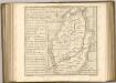
LINCOLNIA | COMITATVS. Anglis | LINCOLN-SHIRE.
[Amsterdam : Joan Blaeu]
Lincolnia Comitatus. Anglis Lincoln-Shire. [Karte], in: Theatrum orbis terrarum, sive, Atlas novus, Bd. 4, S. 335.
1 Karte aus Atlas Blaeu, Joan Blaeu, Willem Janszoon
Lincolnia Comitatus. Anglis Lincoln-Shire. [Karte], in: Le théâtre du monde, ou, Nouvel atlas contenant les chartes et descriptions de tous les païs de la terre, Bd. 4, S. 293.
1 Karte aus Atlas Blaeu, Willem Janszoon und Blaeu, Joan Blaeu, Willem Janszoon
Lincolnia Comitatus. Anglis Lincoln-Shire. [Karte], in: Theatrum orbis terrarum, sive, Atlas novus, Bd. 4, S. 335.
1 Karte aus Atlas Blaeu, Joan Blaeu, Willem Janszoon
Lincolnia Comitatus anglis Lyncolne Shire
1 : 580000 [Amstelodami] : [apud Joannem Janssonium]
Lincolnia comitatus : Anglis Lincoln-Shire
1 : 253000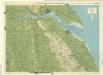
Lincoln Woods, Sheet 10 - Bartholomew's "Half Inch to the Mile Maps" of England & Wales
1 : 126720 Topographic maps Bartholomew, John George John Bartholomew & Co
Lincoln Fens, Sheet 14 - Bartholomew's "Half Inch to the Mile Maps" of England & Wales
1 : 126720 Topographic maps Bartholomew, John George John Bartholomew & Co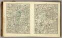
Sheets 42-43. (Cary's England, Wales, and Scotland).
1 : 360000 Cary, John, ca. 1754-1835
Comitatus Nottinghamiensis, sive Nottingham Shire
1 : 240000 [Amstelodami] : [apud Joannem Janssonium]
Grimsby - OS One-Inch Map
1 : 63360 Topographic maps Ordnance Survey Ordnance Survey
Boston and Skegness - OS One-Inch Map
1 : 63360 Topographic maps Ordnance Survey Ordnance Survey
Gainsborough - OS One-Inch Map
1 : 63360 Topographic maps Ordnance Survey Ordnance Survey
Lincon and Grantham - OS One-Inch Map
1 : 63360 Topographic maps Ordnance Survey Ordnance Survey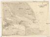
Nordsee
1 : 150000 Grimsby (Anglie) Reichs-Marine-Amt
Louth
1 : 31680 This drawing covers a section of the Lincolnshire coast from Humberstone in the north to Mablethorpe in the south. Down the right of the sheet, the sandy beaches characterising this stretch of the coast are represented by banks of fine dots. Salt marshes are indicated by areas of grey shading. Further inland, the map shows the ditches and dykes constructed to drain the fens. Metcalf, Edward B.
Spalding - OS One-Inch Map
1 : 63360 Topographic maps Ordnance Survey Ordnance Survey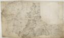
Grantham 24
1 : 31680 This drawing depicts the county boundary of Lincolnshire and Leicestershire as a red dotted line at lower left. The Ermine Street (or High Dyke) is shown running down the right of the sheet. This Roman road extended from Cichester in Sussex to York, passing through Lincolnshire. At lower left, in the Vale of Belvoir, the villages of Plungar, Redmile, Bottesford and Muston are recorded along the Grantham Canal, along with the prominent Belvoir Castle. Budgen, Charles
Spalding
1 : 31680 This drawing covers part of Lincolnshire, showing drains across the fens highlighted in blue. These date from the 17th century, when James I appointed Dutch engineer Cornelius Vermuyden to direct the drainage of the wetlands. Many local people opposed the scheme as the plan involved commonland on which they grazed cattle. As a result of Vermuyden's work, the fens changed radically in appearance, from an area of flooded marshes to one of extensively farmed agricultural land. In the middle of the sheet is a series of decoy ponds, built in the 17th and 18th centuries to lure wildlife. Yeakell, Thomas Jr.
Grimsby
1 : 31680 This drawing covers part of north-east Lincolnshire, showing Grimsby and its harbour on the Humber estuary at top right. An important seaport since the Middle Ages, Grimsby declined in importance as its harbour became blocked by silt from the Humber. The harbour was improved and expanded in the 18th and 19th centuries. Grimsby is now the main fishing port of Great Britain. Metcalf, Edward B.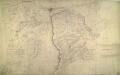
Lincoln
1 : 31680 This drawing shows the county boundary of Lincolnshire and Nottinghamshire as a red dotted line down the left of the sheet. The county town is depicted at the top of the plan on the north bank of the river Witham, set on the summit of the limestone ridge known as the Cliff Hills. Water-filled dykes, constructed to drain the fens, are represented to the right of the sheet, together with the ancient cattle droves, long straight roads that characterise this part of the Lincolnshire landscape. Stevens, Henry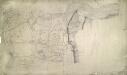
Crowle
1 : 31680 This plan covering the tidal Humber Estuary and the confluence of the rivers Trent and Humber in north Lincolnshire. Along the Humber, the draughtsman has drawn lines or stripes at right angles to the flow of the water. This is an unusual technique: lines were usually drawn parallel to to the course. A section of the Stainforth and Keadby Canal is shown in blue at the bottom of the map, near Althorpe. The manuscript paper carries a watermark from the James Whatman Turkey Mill, Kent, dated 1816. Budgen, Charles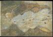
Humber from Hull and Barton to Sea
This is a map showing the River Humber, River Hull and the town of hull. It dates from between 1541-1547. The map is drawn in a loose pictorial style but despite this the defences of Hull are shown in accurate detail. These fortifications were built under the instruction of Henry VIII to protect the eastern side of the town. Plans for the building work were made in 1541 after the king visited in October of that year and dictated that the eastern side of the town, defended only by the River Hull, must be strengthened. At this time Henry VIII feared an invasion from the combined forces of France and Spain. In 1538 Francis I of France, and Charles V Holy Roman Emperor and King of Spain signed a peace treaty. This union gave rise to the possibility that France and Spain may combine forces to invade England. France was England’s historical enemy and Henry VIII’s divorce of Catherine of Aragon, Charles V’s aunt, had offended the militantly catholic King of Spain. The town of Hull, located on the east coast of the country, near the Anglo-Scottish border occupies a position of strategic importance as it provided a base for war against Scotland or Catholic Europe As can be seen here the fortifications at Hull consisted of two large trefoil headed blockhouses’ or bulwarks’ at opposite ends of the harbour, with a castle’ between them. Connecting these fortresses was a crenellated wall almost half a mile long running parallel to the river. This would provide defences which could protect against overland attack from the east, or naval invasion from the Humber. The draughtsman has accurately recorded the unusual trefoil shapes of the bulwarks, the segmental forms of the castle and the angled bend and crenellations of the connecting wall. In December 1543 costs were given as 21,056 5s. 6d in total. This chart could date from as early as October 1541, when the King visited Hull in October 1541 and expressed concern that the east side of the town was vulnerable to an attack.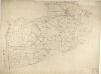
Boston
This drawing covers the part of Lincolnshire known as South Holland. It shows the saltmarshes, intertidal banks of sand and mud, shallow waters and deep channels that characterise the Wash, the largest estuarine system in Britain. Depicted further inland, to the left of the sheet, are ancient cattle droves, the long straight roads that are a prominent feature of this part of Lincolnshire. Budgen, Charles