Maps of West Lindsey

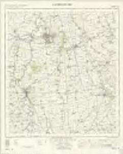
Gainsborough - OS One-Inch Map
1 : 63360 Topographic maps Ordnance Survey Ordnance Survey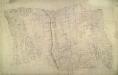
Hackthorn
1 : 31680 This drawing covers part of Lincolnshire (north of Lincoln) known as the Lindsey Part. In the ninth century, after years of raids on the east coast of England, this part of Lincolnshire was finally occupied by the Danes. Evidence of this invasion survives in place names terminating with 'thorpe', an early-Danish word for settlement. The Ermine Street is highlighted in buff down the middle of the plan. This Roman road ran from Chichester in Sussex to York, via Lincolnshire. Pencil rays used to plot the survey are clearly visible on the manuscript. Stevens, Henry
Brigg
1 : 31680 The minimal shading and interlining on this plan conveys the flatness of the land around Brigg. Its complex drainage system is highlighted in blue. Near Market Rasen, "TG" indicates a tollgate. Budgen, Charles
Brigg (Hills) - OS One-Inch Revised New Series
1 : 63360 Topographic maps Ordnance Survey Ordnance Survey
Brigg (Outline) - OS One-Inch Revised New Series
1 : 63360 Topographic maps Ordnance Survey Ordnance Survey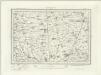
Market Rasen (Outline) - OS One-Inch Revised New Series
1 : 63360 Topographic maps Ordnance Survey Ordnance Survey
Market Rasen (Hills) - OS One-Inch Revised New Series
1 : 63360 Topographic maps Ordnance Survey Ordnance Survey
Kirton
1 : 31680 An ink annotation on the bottom right of the manuscript is dated 27th December 1810 and signed by draughtsman, Charles Budgen. He notes the area of the land as 76.3200 square miles. Ermine Street is shown in faded ochre, forming a boundary to the right of the map.The road was built by the Romans as a supply route for their army during the conquest of Britain. Budgen, C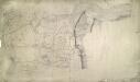
Crowle
1 : 31680 This plan covering the tidal Humber Estuary and the confluence of the rivers Trent and Humber in north Lincolnshire. Along the Humber, the draughtsman has drawn lines or stripes at right angles to the flow of the water. This is an unusual technique: lines were usually drawn parallel to to the course. A section of the Stainforth and Keadby Canal is shown in blue at the bottom of the map, near Althorpe. The manuscript paper carries a watermark from the James Whatman Turkey Mill, Kent, dated 1816. Budgen, Charles
Isle-of-Axholme
1 : 31680 A dashed red-ink line at the bottom of this plan divides the counties of Lincolnshire, Nottinghamshire and Yorkshire. Dykes and drains predominate, and the River Trent is shown running from Althorpe, at the top of the plan, to Gainsborough, at the bottom. The manuscript is quite worn, dirty and ripped, making it difficult to interpret. Budgen, Charles
Kingston upon Hull (Hills) - OS One-Inch Revised New Series
1 : 63360 Topographic maps Ordnance Survey Ordnance Survey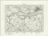
Kingston upon Hull (Outline) - OS One-Inch Revised New Series
1 : 63360 Topographic maps Ordnance Survey Ordnance Survey
Part of Nottinghamshire H. Stevens. 1820.''(002OSD000000004U00252000)
1 : 31680 .This plan covers an area of 82.625 square miles,in Nottinghamshire and Lincolnshire. The county boundary is indicated by a red pecked line following the course of the River Trent down the right of the sheet. Land use is indicated by colours instead of the conventional symbols: dark green for woodland, lighter green for meadows and light brown for arable land. Stevens, Henry
TA01 - OS 1:25,000 Provisional Series Map
1 : 25000 Topographic maps Ordnance Survey Ordnance Survey
TA00 - OS 1:25,000 Provisional Series Map
1 : 25000 Topographic maps Ordnance Survey Ordnance Survey
TF09 - OS 1:25,000 Provisional Series Map
1 : 25000 Topographic maps Ordnance Survey Ordnance Survey
SE91 - OS 1:25,000 Provisional Series Map
1 : 25000 Topographic maps Ordnance Survey Ordnance Survey
TF08 - OS 1:25,000 Provisional Series Map
1 : 25000 Topographic maps Ordnance Survey Ordnance Survey
SE90 - OS 1:25,000 Provisional Series Map
1 : 25000 Topographic maps Ordnance Survey Ordnance Survey
TF07 - OS 1:25,000 Provisional Series Map
1 : 25000 Topographic maps Ordnance Survey Ordnance Survey
SK99 - OS 1:25,000 Provisional Series Map
1 : 25000 Topographic maps Ordnance Survey Ordnance Survey
SE81 - OS 1:25,000 Provisional Series Map
1 : 25000 Topographic maps Ordnance Survey Ordnance Survey
SK98 - OS 1:25,000 Provisional Series Map
1 : 25000 Topographic maps Ordnance Survey Ordnance Survey
SE80 - OS 1:25,000 Provisional Series Map
1 : 25000 Topographic maps Ordnance Survey Ordnance Survey
SK97 - OS 1:25,000 Provisional Series Map
1 : 25000 Topographic maps Ordnance Survey Ordnance Survey
SK89 - OS 1:25,000 Provisional Series Map
1 : 25000 Topographic maps Ordnance Survey Ordnance Survey
SK88 - OS 1:25,000 Provisional Series Map
1 : 25000 Topographic maps Ordnance Survey Ordnance Survey
SK87 - OS 1:25,000 Provisional Series Map
1 : 25000 Topographic maps Ordnance Survey Ordnance Survey
Yorkshire 254a - OS Six-Inch Map
1 : 10560 Topographic maps Ordnance Survey Ordnance Survey